Tarakan, North Kalimantan
| Tarakan | ||
|---|---|---|
| City | ||
| ||
 Location in Kalimantan | ||
 Tarakan Location in Kalimantan | ||
| Coordinates: 3°18′0″N 117°38′0″E / 3.30000°N 117.63333°E | ||
| Country | Indonesia | |
| Province | North Kalimantan | |
| Government | ||
| • Mayor | Ir. Sofyan Raga, M.Si | |
| Elevation | 0 m (0 ft) | |
| Population (2010) | ||
| • Total | 193,069 | |
| Time zone | Central Indonesian Time (UTC+8) | |
| Area code(s) | +62 551 | |
| Website | www.tarakankota.go.id | |
Tarakan, located on Tarakan Island is one of the major cities in northern Borneo, just across the border from Sabah, Malaysia. Once a major oil producing region during the colonial period, Tarakan had great strategic importance during the Pacific War and was among the first Japanese targets early in the war. It is the sole city within the newly established (in 2012) Indonesian province of North Kalimantan.
Etymology
The name Tarakan comes from the Tidung language: Tarak (meeting place) and ngakan (to eat); thus Tarakan was originally a meeting place for sailors and traders in the Tidung area to eat, rest and trade their catch.[1]
History
According to legends, native Tidungs established their kingdom in Tarakan around 1076 CE. After moving their capital several times over the centuries, in 1571 CE they settled their kingdom on the eastern coast of Tarakan, apparently already under influence of Islam.[2]
Dutch colonial interests first explored the island in 1863 when oil seepages were discovered. In 1905 an oil concession was granted to Koninklijke Nederlandsche Petroleum Maatschappij, a predecessor to Royal Dutch Shell. One year later oil production began with a yield of over 57,928 barrels of oil per year. Production continued to increase and in the 1920s Tarakan yielded over 5 million barrels a year, a third of the total oil production in the whole Dutch East Indies.[3]
The oil produced here had a paraffin base instead of the usual asphalt base. This made Tarakan oil an important source of fuel in great demand, especially from Japan.[4]
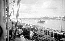
During the beginning of the Second World War in the Pacific, Tarakan was an obvious target for the Japanese. They wanted Tarakan for two reasons: the presence of a rich oil field and to use it as a strategic air base from which further attacks could be launched. In the first battle of Tarakan on January 11–12, 1942, the Japanese invasion fleet defeated the Dutch and took control of Tarakan.[5]
.jpg)
Following the Dutch surrender, Tarakan's inhabitants suffered under Japan's occupation. The large number of Japanese troops stationed on the island caused food shortages and many civilians suffered from malnutrition as a result. During the occupation, the Japanese transported some 600 labourers to Tarakan from Java. The Japanese also forced an estimated 300 Javanese women to work as "comfort women".
Tarakan's value to the Japanese evaporated with the rapid advance of Allied forces. The last Japanese oil tanker left Tarakan in July 1944, and heavy Allied air raids later in the year destroyed the island's oil production and storage facilities.
Allies finally captured Tarakan following the second battle of Tarakan from May 1 – June 21, 1945. The Allied force responsible for capturing Tarakan was centred on the veteran Australian 26th Brigade Group.
Following the Indonesian revolution, Tarakan became part of the new republic. In 1981, Tarakan was granted a city charter, at that time one of four cities in East Kalimantan, along with Samarinda, Balikpapan and Bontang. After North Kalimantan was established as a province in 2012, Tarakan became the sole city within the new province.
Administration
The city is divided into four districts (kecamatan), tabulated below with their 2010 Census population:[6]
| Name | Population Census 2010 |
|---|---|
| Tarakan Timur (East Tarakan) | 42,973 |
| Tarakan Tengah (Central Tarakan) | 60,608 |
| Tarakan Barat (West Tarakan) | 67,749 |
| Tarakan Utara (North Tarakan) | 22,040 |
Demographics
Tarakan had a population of 193,069 at the 2010 Census.[7] Native residents are the Tidung, a subgroup of the Dayak people. In addition, the city also has a multi-ethnic population from other parts of Indonesia, such as Bugis, Javanese and Chinese Indonesians. The majority of the population is Muslim, with a minority of Christian and other religions.[8]
Relations between ethnic groups are generally peaceful, although Tarakan witnessed deadly clashes in the 2010 Tarakan riot.
Transportation
Tarakan is served with several ferries, linking it to other cities on eastern Borneo: Nunukan in North Kalimantan, Berau and Balikpapan in East Kalimantan, and Tawau in Sabah. The port also provides links to cities on other Indonesian islands: Sulawesi and Java.[9]
Tarakan has an airport called Juwata Airport, located 3.5 km from the city. The airport has domestic flight routes to Balikpapan, Jakarta, Surabaya, Denpasar and Makassar, as well as an international route to Tawau, Malaysia.
Economy
Once, the city was a leading oil producer in Dutch East Indies; to-day however, oil only comprises 6% of the total Tarakan economy. The economy is now dominated by fisheries and forest products.[10]
Environment
Tarakan island is of ecological importance. The island is one of the habitats of the Proboscis monkey. Tarakan also provides breeding ground for marine and bird species.[10]
See also
References
- ↑ "Hari Jadi & Sejarah". Tarakan Municipal website.
- ↑ Prasetyo, Deni (2009). Mengenal Kerajaan-Kerajaan Nusantara. Pustaka Widyatama (Yogyakarta).
- ↑ European foreign investments as seen by the U.S. Department of Commerce. United States Bureau of Foreign and Domestic Commerce. 1977.
- ↑ Mindell, Earl P.; John T. Mason (1986). "The Pacific War Remembered: An Oral History Collection". Naval Institute Press.
- ↑ Dull, Paul S. A battle history of the Imperial Japanese Navy, 1941-1945.
- ↑ Biro Pusat Statistik, Jakarta, 2011.
- ↑ Biro Pusat Statistik, Jakarta.
- ↑ "Sekilas Tarakan". Tarakan Municipal website.
- ↑ Atiyah, Jeremy. Rough guide to Southeast Asia. Rough Guides.
- 1 2 Roberts, Brian; Trevor Kanaley (2006). Urbanization and sustainability in Asia: case studies of good practice. Asian Development Bank.
Regencies and cities of North Kalimantan | ||
|---|---|---|
Capital: Tanjung Selor | ||
| Regencies | ||
| Cities | ||
Coordinates: 3°18′0″N 117°38′0″E / 3.30000°N 117.63333°E