Talmage, California
| Talmage | |
|---|---|
| census-designated place | |
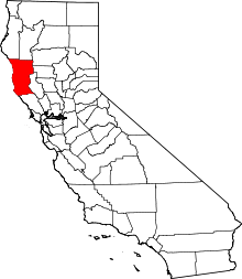
 Location in Mendocino County and the state of California | |
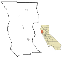
 Talmage Location in the United States | |
| Coordinates: 39°08′00″N 123°10′04″W / 39.13333°N 123.16778°WCoordinates: 39°08′00″N 123°10′04″W / 39.13333°N 123.16778°W | |
| Country |
|
| State |
|
| County | Mendocino |
| Area[1] | |
| • Total | 1.592 sq mi (4.122 km2) |
| • Land | 1.590 sq mi (4.118 km2) |
| • Water | 0.002 sq mi (0.004 km2) 0.10% |
| Elevation[2] | 627 ft (191 m) |
| Population (2010) | |
| • Total | 1,130 |
| • Density | 710/sq mi (270/km2) |
| Time zone | Pacific (PST) (UTC-8) |
| • Summer (DST) | PDT (UTC-7) |
| ZIP code | 95481 |
| Area code(s) | 707 |
| FIPS code | 06-77784 |
| GNIS feature ID | 1659949 |
Talmage (variant, Talmadge)[2] is a census-designated place (CDP) in Mendocino County, California, United States. Talmage is located 2.5 miles (4 km) east-southeast of Ukiah,[3] at an elevation of 627 feet (191 m).[2] The population was 1,130 at the 2010 census, down from 1,141 at the 2000 census. It lies on the Southeastern region of Ukiah Valley and is home to the famous City of Ten Thousand Buddhas, one of the largest Chinese Zen Buddhist temples in the United States. The town's name honors early settler Junius Talmage.[3]
Geography
Talmage is located at 39°08′00″N 123°10′04″W / 39.13333°N 123.16778°W.[2]
According to the United States Census Bureau, the CDP has a total area of 1.6 square miles (4.1 km2), 99.90% of it land, and 0.10% of it water.
Demographics
2010
The 2010 United States Census[4] reported that Talmage had a population of 1,130. The population density was 710.1 people per square mile (274.2/km²). The racial makeup of Talmage was 503 (44.5%) White, 3 (0.3%) African American, 27 (2.4%) Native American, 273 (24.2%) Asian, 4 (0.4%) Pacific Islander, 278 (24.6%) from other races, and 42 (3.7%) from two or more races. Hispanic or Latino of any race were 366 persons (32.4%).
The Census reported that 911 people (80.6% of the population) lived in households, 199 (17.6%) lived in non-institutionalized group quarters, and 20 (1.8%) were institutionalized.
There were 330 households, out of which 120 (36.4%) had children under the age of 18 living in them, 153 (46.4%) were opposite-sex married couples living together, 41 (12.4%) had a female householder with no husband present, 26 (7.9%) had a male householder with no wife present. There were 25 (7.6%) unmarried opposite-sex partnerships, and 5 (1.5%) same-sex married couples or partnerships. 85 households (25.8%) were made up of individuals and 25 (7.6%) had someone living alone who was 65 years of age or older. The average household size was 2.76. There were 220 families (66.7% of all households); the average family size was 3.37.
The population was spread out with 271 people (24.0%) under the age of 18, 137 people (12.1%) aged 18 to 24, 270 people (23.9%) aged 25 to 44, 338 people (29.9%) aged 45 to 64, and 114 people (10.1%) who were 65 years of age or older. The median age was 37.0 years. For every 100 females there were 82.0 males. For every 100 females age 18 and over, there were 80.5 males.
There were 382 housing units at an average density of 240.0 per square mile (92.7/km²), of which 155 (47.0%) were owner-occupied, and 175 (53.0%) were occupied by renters. The homeowner vacancy rate was 1.3%; the rental vacancy rate was 11.2%. 404 people (35.8% of the population) lived in owner-occupied housing units and 507 people (44.9%) lived in rental housing units.
2000
As of the census[5] of 2000, there were 1,141 people, 327 households, and 229 families residing in the CDP. The population density was 725.6 people per square mile (280.6/km²). There were 335 housing units at an average density of 213.0 per square mile (82.4/km²). The racial makeup of the CDP was 57.41% White, 0.61% African American, 2.45% Native American, 16.48% Asian, 0.09% Pacific Islander, 17.62% from other races, and 5.35% from two or more races. Hispanic or Latino of any race were 27.17% of the population.
There were 327 households out of which 44.3% had children under the age of 18 living with them, 49.2% were married couples living together, 15.9% had a female householder with no husband present, and 29.7% were non-families. 23.2% of all households were made up of individuals and 8.9% had someone living alone who was 65 years of age or older. The average household size was 2.87 and the average family size was 3.34.
In the CDP the population was spread out with 29.8% under the age of 18, 11.0% from 18 to 24, 29.2% from 25 to 44, 20.5% from 45 to 64, and 9.6% who were 65 years of age or older. The median age was 31 years. For every 100 females there were 95.7 males. For every 100 females age 18 and over, there were 90.7 males.
The median income for a household in the CDP was $31,761, and the median income for a family was $35,972. Males had a median income of $22,250 versus $25,179 for females. The per capita income for the CDP was $16,656. About 29.2% of families and 23.8% of the population were below the poverty line, including 42.1% of those under age 18 and none of those age 65 or over.
Sites of interest
Talmage is the site of the Mendocino State Mental Hospital (formerly the Mendocino State Asylum for the Insane), the destination for inmates charged with crimes but found not guilty by reason of insanity. The hospital first opened in 1893 with one building at a site near the town of Ukiah, California. Its first patients, all male, were transferred from state mental institutions in Stockton and Napa. Female patients were accepted beginning in 1894. Two additional wards were built in 1910 and 1918, respectively. A major renovation and expansion of the facility took place between 1925–1933. By 1932, the hospital had over 1900 patients and 300 employees. By 1935, the figure had risen to over 2600 patients. Hospital population hit a high in 1955 at over 3,000 patients and 700 employees. Increasing discharges and transfer of the criminally insane to the Atascadero mental facility eased overcrowding. The original main building, completed in 1893, was razed in 1952. By 1966, population was back under 1800 patients. The hospital was closed in 1972.
The City of Ten Thousand Buddhas, a Buddhist community and monastery, is located there.
Politics
In the state legislature, Talmage is in the 2nd Senate District, represented by Democrat Mike McGuire,[6] and the 2nd Assembly District, represented by Democrat Jim Wood.[7]
Federally, Talmage is in California's 2nd congressional district, represented by Democrat Jared Huffman.[8]
References
- ↑ U.S. Census Archived 2012-07-14 at WebCite
- 1 2 3 4 U.S. Geological Survey Geographic Names Information System: Talmage, California
- 1 2 Durham, David L. (1998). California's Geographic Names: A Gazetteer of Historic and Modern Names of the State. Clovis, Calif.: Word Dancer Press. p. 154. ISBN 1-884995-14-4.
- ↑ "2010 Census Interactive Population Search: CA - Talmage CDP". U.S. Census Bureau. Retrieved July 12, 2014.
- ↑ "American FactFinder". United States Census Bureau. Retrieved 2008-01-31.
- ↑ "Senators". State of California. Retrieved March 10, 2013.
- ↑ "Members Assembly". State of California. Retrieved March 2, 2013.
- ↑ "California's 2nd Congressional District - Representatives & District Map". Civic Impulse, LLC. Retrieved March 1, 2013.