Tallapoosa River
| Tallapoosa River | |
|---|---|
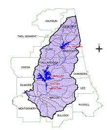 Tallapoosa River drainage (Alabama counties) in 4 lakes: Harris Lake, Martin Lake, Yates Lake & Tallasee Lake | |
| Basin | |
| Main source | 33°50′48″N 85°00′45″W / 33.84667°N 85.01250°W |
| River mouth | 32°30′09″N 86°15′48″W / 32.50250°N 86.26333°WCoordinates: 32°30′09″N 86°15′48″W / 32.50250°N 86.26333°W |
The Tallapoosa River runs 265 miles (426 km)[1] from the southern end of the Appalachian Mountains in Georgia, United States, southward and westward into Alabama. It is formed by the confluence of McClendon Creek and Mud Creek in Paulding County, Georgia. Lake Martin at Alexander City, Alabama is a large and popular water recreation area formed by a dam on the river. The Tallapoosa joins the Coosa River about 10 miles (16 km) northeast of Montgomery near Wetumpka (in Elmore County) to form the Alabama River.
There are four hydroelectric dams on the Tallapoosa: Yates Dam, Thurlow, Martin and Harris Dam; they are important sources of electricity generation for Alabama Power (a unit of the Southern Company) and recreation for the public.
The Tallapoosa River, especially its lower course, was a major population center of the Creek Indians before the early 19th century. The contemporary name of the river is from the Creek words Talwa posa, which mean Grandmother Town. The Creek consider the Tallapoosa branch of their tribe to be one of the oldest.
Horseshoe Bend National Military Park, a U.S. National Military Park managed by the National Park Service, sits on the banks of the Tallapoosa River just upstream from Lake Martin.[2]
The river below Thurlow Dam provides a short run of outstanding Class II, III and IV whitewater kayaking.[3]
Tallapoosa, Georgia, is named for the river, which runs near the town.
Impoundments
The Tallapoosa River, at the site where Yates Dam now sits, was the earlier site of the first hydroelectric dam in Alabama, built in 1902, by Henry C. Jones, an Auburn University electrical engineer. Rebuilt after the flood of 1919, the dam that then belonged to the Montgomery Light & Water Power Company was replaced by a third dam, the 1928 Yates Dam.[4]
There are four hydroelectric dams on the Tallapoosa River: Yates Dam, Thurlow Dam, Martin Dam, and R.L. Harris Dam.
The table below outlines the four impoundments (dams) on the Tallapoosa River from south to north.
| Impoundment | Description | Images |
|---|---|---|
| Lake Thurlow (Lower Tallasee Dam) | Lake Thurlow was impounded in 1930. Thurlow Dam was built in Tallassee at the site of an early 19th-century textile mill that was used during the Civil War as a uniform and ammunition plant. The Benjamin Fitzpatrick Bridge spans the river immediately south of Thurlow Dam. |  |
| Lake Yates (Upper Tallasee Dam) | Lake Yates was impounded July 1, 1928 and named for Eugene A. Yates, the Chief Engineer for Alabama Power dam building efforts hired in 1912. The nearest town is Tallassee, Alabama. One public access site is maintained by Alabama Power.[4][5] |  |
| Lake Martin | Lake Martin was impounded December 31, 1926 and named for Thomas Martin, president of Alabama Power Company from 1920 to 1949 and chief executive officer from 1949 to 1963. The lake impounds 44,000 acres (160 km²) with 700 miles (1000 km) of shoreline. The nearest town is Alexander City, Alabama. Lake Martin is an Alabama Power lake with an 154,200 kilowatt generating capacity. It is an excellent recreational lake with fishing opportunities for largemouth bass, spotted bass, bluegill and other sunfish, crappie, catfish, striped bass and white bass. Alabama Power maintain eleven public access sites maintained on the lake.[6] |  |
| Lake R. L. Harris (Lake Wedowee) | Lake R. L. Harris Lake was impounded April 20, 1983 and named for Rother L. "Judge" Harris, an Alabama Power director and vice president of electric operations. The lake covers 10,600 acres (43 km²) with 271 miles (436 km) of shoreline. The nearest town is Lineville, Alabama. R. L. Harris is an Alabama Power lake with an 135,000 kilowatt generating capacity. It is an excellent recreational lake with fishing opportunities for largemouth bass, spotted bass, bluegill and other sunfish, crappie, catfish, striped bass, hybrid and white bass. Alabama Power maintains six public access sites on the lake.[7] |  |
Significant tributaries
The Tallapoosa River's drainage has many significant tributaries which reflected below based on their location within the watershed.
| Location | Tributaries |
|---|---|
| Headwaters to H.L. Harris Dam | Little Tallapoosa River |
| H.L. Harris Dam to Martin Dam | Emuckfaw Creek, Sandy Creek, Wind Creek, Chikasanoxee Creek, Hillabee Creek |
| Martin Dam to Yates Dam | Saugahatchee Creek |
| Yates Dam to Thurlow Dam | No Major Tributaries |
| Thurlow Dam to Coosa River Confluence | Tumcheehatchee Creek, Chubbehatchee Creek, Cubahatchee Creek, Calabee Creek |
Advocates
The Coosa-Alabama River Improvement Association, founded in 1890 in Gadsden, Alabama to promote navigation on the Coosa River is a leading advocate of the economic, recreational and environmental benefits of the Coosa and Tallapoosa River systems.[8]
The Alabama Rivers Alliance works to unite the citizens of Alabama to protect peoples right to clean, healthy, waters.[9]
Alabama Water Watch is dedicated to volunteer citizen monitoring of water quality in Alabama Rivers.[10]
The Alabama Power Foundation is a non-profit foundation providing grants for watershed, environmental and community projects along the Tallapoosa River and within the state of Alabama[11]
The Coosa River Basin Initiative is a grassroots environmental organization with the mission of informing and empowering citizens so that they may become involved in the process of creating a clean, healthy and economically viable Coosa River Basin.[12]
Major cities
A number of significant cities lie on the banks of the Tallapoosa River. They include:
- Heflin, Alabama - headwaters
- Buchanan, Georgia - headwaters
- Tallapoosa, Georgia - headwaters
- Wedowee, Alabama - near R. L Harris Lake (Lake Wedowee)
- Lineville, Alabama - near R.L harris Lake (Lake Wedowee
- Alexander City, Alabama - north flank of Lake Martin
- Dadeville, Alabama - south flank of Lake Martin
- Tallassee, Alabama - site of Lower Tallassee Dam
- Wetumpka, Alabama - near confluence with Coosa River forming the Alabama River
- Montgomery, Alabama - Tallapoosa River is major source (60%) of drinking water for city.[13]
References
- Atkins, Leah Rawls (2006). "Developed for the Service of Alabama" - The Centennial History of the Alabama Power Company 1906-2006. Birmingham, Alabama: Alabama Power Company. ISBN 978-0-9786753-0-1.
- Jackson, Harvey H. III (1997). Putting Loafing Streams To Work-The Building of Lay, Mitchell, Martin, and Jordan Dams, 1910-1929. Tuscaloosa, Alabama: The University of Alabama Press. ISBN 0-8173-0879-2.
- Jackson, Harvey H. III (1995). Rivers of History-Life on the Coosa, Tallapoosa, Cahaba and Alabama. Tuscaloosa, Alabama: The University of Alabama Press. ISBN 0-8173-0771-0.
Notes
- ↑ U.S. Geological Survey. National Hydrography Dataset high-resolution flowline data. The National Map Archived 2012-04-05 at WebCite, accessed April 27, 2011
- ↑ National Park Service; Horseshoe Bend National Military Park; Directions
- ↑ Alabama White Water Website
- 1 2 Atkins, Leah Rawl (2006). "Developed for the Service of Alabama" - The Centennial History of the Alabama Power Company 1906-2006. Birmingham, Alabama: Alabama Power Company. pp. 154–55. ISBN 978-0-9786753-0-1.
- ↑ Atkins, Leah Rawl (2006). "Developed for the Service of Alabama" - The Centennial History of the Alabama Power Company 1906-2006. Birmingham, Alabama: Alabama Power Company. pp. 37–38. ISBN 978-0-9786753-0-1.
- ↑ Power Website, Facts About Dams
- ↑ Alabama Power Website, Facts About Dams
- ↑ Coosa-Alabama River Improvement Association Website, History
- ↑ Alabama Rivers Alliance Website
- ↑ Water Watch Website
- ↑ Alabama Power Foundation Website
- ↑ Coosa River Basin Initiative website
- ↑ Montgomery Water and Sewer Works Facilities
External links
| Wikimedia Commons has media related to Tallapoosa River. |