Taksin Bridge
| Taksin Bridge | |
|---|---|
 | |
| Coordinates | 13°43′08″N 100°30′45″E / 13.718791°N 100.512543°ECoordinates: 13°43′08″N 100°30′45″E / 13.718791°N 100.512543°E |
| Carries | 6 lanes of roadway, Bangkok Skytrain, pedestrians |
| Crosses | Chao Phraya river |
| Locale | Bangkok, Thailand |
| Official name | King Taksin Bridge |
| Characteristics | |
| Total length | 1,791 m |
| Longest span | 92 m |
| Clearance below | 12 m |
| History | |
| Construction end | 1 February 1979 |
| Opened | 6 May 1982 |
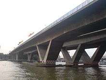
The Taksin Bridge (Thai: สะพานสมเด็จพระเจ้าตากสิน) is a bridge crossing the Chao Phraya river in Bangkok, Thailand. The bridge was designed with a large gap between opposing traffic directions to accommodate a canceled mass transit system. The disused foundations were eventually adapted for the BTS Skytrain,[1] with train services across the bridge beginning on 15 May 2009.
The entry ramp on the east side of the river contains the Saphan Taksin Skytrain station as well as a pier for the Chao Phraya Express Boat.
See also
References
- ↑ "THE 1979 BANGKOK MASS TRANSIT MASTERPLAN". 2bangkok.com. Retrieved 2007-11-27.
External links
- Taksin Bridge Bureau of Maintenance and Traffic Safety, Thailand. Retrieved on 31 December 2007
This article is issued from Wikipedia - version of the 1/23/2016. The text is available under the Creative Commons Attribution/Share Alike but additional terms may apply for the media files.