Taixinan Basin
The Taixinan Basin (Chinese: 台西南盆地; pinyin: Táixīnán Péndì), sometimes rendered literally as Southwest Taiwan Basin or Southwestern Taiwan Basin, also called the Tainan Basin (Chinese: 台南盆地), is a basin located in the southern Taiwan Strait and the northeastern South China Sea.[1]
Location
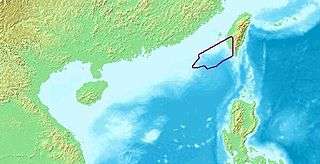
The Taixinan Basin is in the southern Taiwan Strait and the northeastern South China Sea. It is bordered by the Penghu Uplift (Chinese: 澎湖隆起) in the north, the Dongsha Uplift in the southwest, and the South China Sea basin in the south. It is separated from the Zhujiangkou Basin (Chinese: 珠江口盆地) by the Dongsha Uplift. In the northeast, it stretches inland onto the southwest Taiwan Island.[2]
Evolution
Taixinan Basin is located on the continental shelf, on the margin of the continental crust.[2] Its tectonic evolution can be divided in three periods. The first peiod was from Paleocene to Oligocene. Starting in the Paleocene, Taixinan Basin had been experiencing the effect of rifting, which eventually caused the formation of the basin. The tensile stress field was in the NE-SW direction. Many normal faults developed at this period. The second period was the end of Oligocene. During this period, the Taixinan Basin experienced the effect of compression. Part of the early normal faults underwent tectonic inversion, and a lot of reverse faults and related folds developed. The third period was the thermal subsidence beginning from Miocene. Since the late Miocene, the South China Sea basin stopped its expansion. During this period, the sediment layers are horizontal and basically not controlled by the effects of faulting.[3][4][5]
Topography
The Taixinan Basin is in the direction of NE, with a length of about 400km, average width of 150 km, and an area of more than 60000 km2.[2]
In the Taixinan Basin, there are two depressions in the north and the south, separated by an uplift in the NE direction. The thickness of the Cenozoic sediments in the depressions can reach 8000 m, increasing from west to east. In the eastern part of the basin, the thickness of the sediments can reach 7000 m offshore Kaohsiung.[2]
Onshore, on the southwest Taiwan Island, there is a distribution of normal faults of Paleogene.[6]