Tahune AirWalk
| Tahune AirWalk | |
|---|---|
|
The cantilever bridge on the Tahune Forest AirWalk | |
| Coordinates | 43°05′42″S 146°43′30″E / 43.09500°S 146.72500°ECoordinates: 43°05′42″S 146°43′30″E / 43.09500°S 146.72500°E |
| Carries | Pedestrians |
| Crosses | Huon River; Picton River |
| Locale | Geeveston, Tasmania, Australia |
| Owner | Forestry Tasmania |
| Website | http://tahuneairwalk.com.au/ |
| Characteristics | |
| Design | footbridge footbridge |
| Material | Steel |
| Total length | 620 metres (2,030 ft) |
| Height | 50 metres (160 ft) |
| History | |
| Opened | 1 July 2001 |
 Tahune AirWalk Location in Tasmania | |

The Tahune AirWalk a steel walkway footbridge located in the Tahune Forest area 29 km from Geeveston and sits over the banks of the Huon River. Located in the Huon Valley of southern Tasmania, Australia. The Tahune Airwalk walkway and visitor Centre is operated as a tourist attraction by Forestry Tasmania.
Location and features
The walkway is located approximately 70 kilometres (43 mi) south of Tasmania's capital city Hobart. The treetop walk overlooks the Huon and Picton Rivers joining in the far distance. The Tahune Airwalk site offers three walks onsite plus the Cable Eagle Hang Gliding.
The footbridge is a level steel structure with a steel walkway that is suspended over the treetops, as high as 50 metres (160 ft) in places. The footbridge is 620 metres (2,030 ft) long, with 1.6 kilometres (0.99 mi) of access paths to the bridge and 112 steps to climb to the peak. Transport is provided to the start of the AirWalk for those with walking difficulties.[1][2] The visitor centre has a fully licensed cafe and is open on a daily basic. Plus browse through the extensive range of exclusive souvenirs. The site has WIFI available at the visitor centre.
Gallery
 View from the Tahune Forest AirWalk.
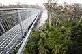 View from the cantilever bridge on the Tahune Forest AirWalk.
 View of the Tahune Forest AirWalk gantry winding through the trees.
 Cable Eagle Hang Gliding
 Swinging Bridge
See also
References
- ↑ "Tahune AirWalk". Parks and Wildlife Service Tasmania. Retrieved 2 May 2012.
- ↑ "Tahune AirWalk Tasmania". Forestry Tasmania. Retrieved 3 August 2015.
External links
Southern region of Tasmania, Australia | |||||||
|---|---|---|---|---|---|---|---|
| City Other settlements | |||||||
| Governance former | |||||||
| Mountains |
| ||||||
| Protected areas, parks and reserves | |||||||
| Rivers | |||||||
| Harbours, bays, inlets and estuaries | |||||||
| Coastal features | |||||||
| Transport | |||||||
| Landmarks |
| ||||||
| Islands | |||||||
| Books and newspapers | |||||||
| Flora, fauna, and fishlife | |||||||
| Bioregions | |||||||
| Indigenous heritage | |||||||
| Other | |||||||
| |||||||