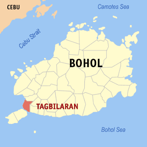
Tagbilaran
| Tagbilaran | |||
|---|---|---|---|
| City | |||
|
Tagbilaran, Bohol | |||
| |||
| Nickname(s): City of Peace and Friendship | |||
 Map of Bohol with Tagbilaran highlighted | |||
.svg.png) Tagbilaran Location within the Philippines | |||
| Coordinates: 9°39′N 123°51′E / 9.65°N 123.85°ECoordinates: 9°39′N 123°51′E / 9.65°N 123.85°E | |||
| Country | Philippines | ||
| Region | Central Visayas (Region VII) | ||
| Province | Bohol (capital) | ||
| District | 1st district of Bohol | ||
| Incorporated • Town • City |
9 February 1742 1 July 1966 | ||
| Barangays | 15 (see § Barangays) | ||
| Government [1] | |||
| • Type | Sangguniang Panlungsod | ||
| • Mayor | John Geesnell Yap (LP) | ||
| • Vice mayor | Jose Antonio Veloso | ||
| • City Council |
Members
| ||
| • Representative | Rene Relampagos | ||
| Area[2] | |||
| • Total | 36.5 km2 (14.1 sq mi) | ||
| • Land | 32.70 km2 (12.63 sq mi) | ||
| Population (2015 census)[3] | |||
| • Total | 105,051 | ||
| • Density | 2,900/km2 (7,500/sq mi) | ||
| • Voter (2016)[4] | 59,949 | ||
| Demonym(s) | Tagbilaranon | ||
| Time zone | PST (UTC+8) | ||
| Zip code | 6300 | ||
| IDD : area code | +63 (0)38 | ||
| Income class | 3rd class | ||
| PSGC | 071242000 | ||
| Website |
tagbilaran | ||


Tagbilaran is a 3rd city income class component city in the island province of Bohol, Philippines,[2] serving as its capital. Its income classification has an annual income of ₱240-320 million. According to the 2015 census, it has a population of 105,051.[3] In the 2016 election, it had 59,949 registered voters.[4]
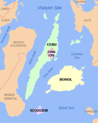
Tagbilaran lies in the southwestern part of the province, and has a total land area of 32.7 km2 (12.6 sq mi), with a coastline of 13 km (8.1 mi). The city shares its boundaries with the towns of Cortes, Corella, and Baclayon. Tagbilaran is the principal gateway to Bohol, 630 km (390 mi) southeast of the national capital of Manila and 72 km (45 mi) south of the regional capital, Cebu City.
History
A hundred years before Spaniards arrived in the Philippines, the settlement which eventually became Tagbilaran was already involved in trading with China and Malaya. This early settlement had contact with the Spaniards in 1565, when the Spanish conquistador Miguel López de Legazpi and the native chieftain Datu Sikatuna pledged peace and cooperation through the famous blood compact.
(San Jose de) Tagbilaran was established as a town on 9 February 1742, by General Don Francisco Antonio Calderón de la Barca, Governor of the Visayas, who separated it from the town of Baclayon. The town was dedicated to St. Joseph the Worker. Since then it was part of the province of Bohol until it became a chartered city on 1 July 1966, by virtue of Republic Act No. 4660.
The city was occupied by the United States during the Philippine-American War and by Imperial Japan during World War II.
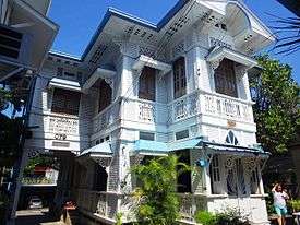
Sitio Ubos (Lower Town) is Tagbilaran's former harbor site and is considered to be the city's oldest portion, having been a busy trading center since the seventeenth century until the early twentieth century. As such, the place houses the oldest and largest number of heritage houses in Bohol. Sitio Ubos declined as a major port towards the end of the Spanish era when the causeway to Panglao Island was constructed. Since then, the area lost its former glory and its old houses were either demolished or neglected.[5]
In 2002, in recognition of its cultural and historic significance, Sitio Ubos was declared a "Cultural Heritage Area". Some of the surviving heritage houses to this day include the Rocha–Suarez House, Rocha House, Hontanosas House, Beldia House, and Yap House.[5]
Historic events
One of the most important events in Philippine history (immortalized on canvas by the famous Filipino painter Juan Luna) was the blood compact between Datu Sikatuna, a local native chieftain, and Captain Miguel López de Legazpi, the Spanish explorer and colonizer. It took place in the coast of Bool, now a district of Tagbilaran, on 16 March 1565, a day after Legazpi and his crew of conquistadores on four ships chanced upon the shores of Bool during their trip to the province of Butuan from Camiguin Island because of strong southwest monsoon winds and low tide.
On that day, 16 March 1565, Legazpi with Fray Andres de Urdaneta and some of his crew set foot on land for an audience with the local chieftain Sikatuna. The two bands of different race and creed met a few hundred meters from the beach and, after a few pleasantries, the Basque seafarer and the chieftain of Bohol sealed and strengthened their treaty of friendship in a historic blood compact. Sikatuna and Legazpi each made a cut on the left arm and collected the drop of blood into a single vessel mixed with wine. To honor this treaty of friendship, the late President Elpidio Quirino established the "Order of Sikatuna", a presidential award and decoration conferred upon visiting dignitaries. A marker now stands on the spot where Sikatuna and Legaspi allegedly sealed that famous compact.[lower-alpha 1]
Another significant event that took place during the Japanese Occupation was the Battle of Ubujan wherein a guerrilla unit under the command of Captain Francisco Salazar (a.k.a. Vicente Cubello) engaged Japanese troops against overwhelming odds. It was a display of Boholano bravery against the well-equipped, well-trained Japanese soldiers.[6]
2013 Earthquake
An earthquake with magnitude 7.2, with an epicenter near Sagbayan, Bohol, struck Bohol on 15 October 2013. Tagbilaran received four fatalities and 21 injuries, and damage to buildings, including the seaport, airport, and city hall.
Geographic
Climate
| Climate data for Tagbilaran, Bohol | |||||||||||||||
|---|---|---|---|---|---|---|---|---|---|---|---|---|---|---|---|
| Jan | Feb | Mar | Apr | May | Jun | Jul | Aug | Sep | Oct | Nov | Dec | Year | |||
| 30.2 86.4 |
30.6 87.1 |
31.5 88.7 |
32.6 90.7 |
33.1 91.6 |
32.5 90.5 |
32.1 89.8 |
32.4 90.3 |
32.3 90.1 |
31.9 89.4 |
31.7 89.1 |
31.0 87.8 |
31.8 89.2 | |||
| 26.1 79.0 |
26.4 79.5 |
27.0 80.6 |
27.9 82.2 |
28.5 83.3 |
28.1 82.6 |
27.8 82.0 |
28.0 82.4 |
27.9 82.2 |
27.5 81.5 |
27.4 81.3 |
26.8 80.2 |
27.5 81.5 | |||
| 22.1 71.8 |
22.2 72.0 |
22.5 72.5 |
23.2 73.8 |
23.9 75.0 |
23.7 74.7 |
23.6 74.5 |
23.7 74.7 |
23.5 74.3 |
23.2 73.8 |
23.1 73.6 |
22.7 72.9 |
23.1 73.6 | |||
| 118 4.6 |
94 3.7 |
87 3.4 |
75 3.0 |
92 3.6 |
152 6.0 |
131 5.2 |
118 4.6 |
131 5.2 |
193 7.6 |
213 8.4 |
132 5.2 |
1,536 60 | |||
| Climate-data.org[7] | Köppen-Geiger climate classification Af | Coronas type III | |||||||||||||
Barangays
There are 15 barangays comprising Tagbilaran, with a population of 105,051 for the year 2015 census,[3] and an annual growth rate of 1.57%. However, 44% of the city's population reside in the four urban districts where trade and commerce are also concentrated.
|
| |||||||||||||||||||||||||||||||||||||||||||||||||||||||||||||||||||||||||||||||||||||||||||||||||||||||||||||||||||||||||||||||||||||||||||||||||||||||||||||||||||||||||||||||||||||||||||||||||||

Demographics
| Flag |
|
|---|---|
| Hymn | Tagbilaran Hymn |
| Dance | Kuradang |
| Bird | Tailor bird (Tamsi) |
| Fish | Rabbitfish (Danggit) |
| Flower | Bougainvillea |
| Tree | Acacia |
| Plant | Golden Duranta |
| Population census of Tagbilaran | |||||||||||||||||||||||||
|---|---|---|---|---|---|---|---|---|---|---|---|---|---|---|---|---|---|---|---|---|---|---|---|---|---|
|
| ||||||||||||||||||||||||
| Source: Philippine Statistics Office[3][8][9] | |||||||||||||||||||||||||
In the 2016 election, it had 59,949 registered voters, meaning that 57% of the population are aged 18 and over.[4]
Local government
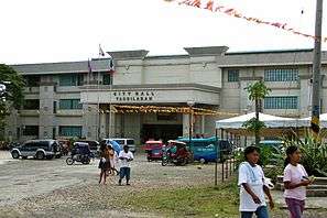 City Hall of Tagbilaran
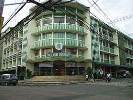 Holy Name University (Lessage Street)
 University of Bohol (Maria Clara Street)
 Center of Tagbilaran with Borja Family Hospital on the right
Chief Executives since 1742
The city is governed locally by a mayor, although historically by a gobernadorcillo and presidente municipal afterwards.
| Chief Executives of Tagbilaran since 1742 | |||
|---|---|---|---|
| Term | Title | Name | |
| Gobernadorcillo | Calixto Marcos | ||
| Sector Leader of Dagohoy | Calixto Sotero | ||
| unknown | Gobernadorcillo | Martin Flores | |
| unknown | Gobernadorcillo | Manuel de la Peña | |
| Gobernadorcillo | Leonardo Guillermo | ||
| Gobernadorcillo | Leon Torralba | ||
| Gobernadorcillo | Francisco Reales | ||
| Gobernadorcillo | Esteban Butalid | ||
| Gobernadorcillo | Alejandro Fama | ||
| Gobernadorcillo | Pedro Matig‑a | ||
| Gobernadorcillo | Felipe Rocha | ||
| Gobernadorcillo | Jacinto Borja y Borja | ||
| Gobernadorcillo | Flaviano Ramirez | ||
| Gobernadorcillo | Manuel Miñoza | ||
| Gobernadorcillo | Eduardo Calceta | ||
| Presidente Municipal | Salustiano Borja | ||
| Presidente Municipal | Margarito Torralba | ||
| Presidente Municipal | Claudio Gallares | ||
| Presidente Municipal | Anecito Clarin | ||
| Presidente Municipal | Macario Sarmiento | ||
| Presidente Municipal | Servando Matig‑a | ||
| Presidente Municipal | Mariano Parras | ||
| Presidente Municipal | Margarito Torralba | ||
| Presidente Municipal | Gaudencio Mendoza | ||
| Presidente Municipal | Lorenzo Torralba | ||
| Presidente | Felipe Sarmiento | ||
| Presidente | Miguel Parras | ||
| Presidente | Nicolas Butalid | ||
| Presidente | Celestino Gallares | ||
| Presidente | Jacinto Remolador | ||
| Presidente | Gregorio Peñaflor | ||
| Presidente | Felipe Sarmiento | ||
| Presidente | Timoteo Butalid | ||
| Presidente | Andres Torralba | ||
| Presidente | Genaro Visarra | ||
| Municipal Mayor | Honorio Grupo | ||
| Municipal Mayor | Manuel Espuelas | ||
| Municipal Mayor | Mariano Rocha | ||
| Municipal Mayor | Manuel Espuelas | ||
| Municipal Mayor | Honorio Grupo | ||
| Municipal Mayor | Pedro Belderol | ||
| Municipal/City Mayor | Venancio Inting | ||
| City Mayor | Rolando Butalid | ||
| City Mayor | Jose Ma Rocha | ||
| OIC City Mayor | Dan Lim | ||
| OIC City Mayor | Jose Torralba | ||
| OIC City Mayor | Carmen Gatal | ||
| OIC City Mayor | Bonifacio Libay | ||
| OIC City Mayor | Ismael Villamor | ||
| City Mayor | Jose Torralba | ||
| City Mayor | Jose Ma Rocha | ||
| City Mayor | Jose Torralba | ||
| City Mayor | Dan Lim | ||
| City Mayor | John Geesnell Yap | ||
Education
As the capital of Bohol, Tagbilaran is the main center for education in the province. All of the province's universities are located in the city as well as other well-known institutions of learning.
-
- AMA Computer Learning Center (ACLC)
- Bohol Island State University (BISU)
- BIT International College (BIT-IC, formerly Bohol Institute of Technology (BIT))
- Bohol Technical Institute (BTI)
- Bohol Wisdom School
- Cristal e-College
- Holy Name University
- Holy Spirit School of Tagbilaran
- Immaculate Heart of Mary Seminary (IHMS)
- PMI Colleges Bohol
- STI College
- University of Bohol
Health
The city is served with a mix of public and private health care institutions that also cater to the health needs of the rest of the province. Complex major cases and services are sent to nearby Cebu City due to lack of facilities.
-
- Holy Name University Medical Center Foundation, Inc.
- Borja Family Hospital Corporation
- Englewood Hospital
- Governor Celestino Gallares Memorial Regional Hospital (tertiary public)
- MMG Bohol Cooperative Hospital
- Ramiro Community Hospital (tertiary private)
- Bohol St. Jude General Hospital
- Tagbilaran Community Hospital
- Tagbilaran Maternity and Children's Hospital
Economy

The city has the advantage of being the province's main business capital and center of governance, education and transportation. Local and international visitors to Bohol pass through the city via the Port of Tagbilaran and Tagbilaran Airport.
Alturas Group, Bohol Quality Corporation and Alvarez Group are some of the notable locally owned companies based in the city.
Transportation


Tagbilaran's land network consists of sealed and unsealed roads. Local transport plying the routes within the city are tricycles, multicabs, taxis, and jeepneys. Buses, taxis and vans are usually hired for out-of-town travel. The Integrated Bus Terminal (IBT) located in the city district of Dao serves as the terminal point for public transport vehicles serving the inter-city routes within the province and also serves as the embarkation point for passengers taking the Pan-Philippine Highway (AH26) bus route from Tagbilaran to Metro Manila. There is also a long-distance bus station within Cogon market.
The city is linked by sea to the major port cities in the Visayas Islands and Mindanao, which of major commercial importance is its link to the regional capital of Cebu City. A fastcraft ferry ride to Cebu City takes approximately 2 hours depending on weather and sea conditions. The route is served by Ocean Jet, Weesam Express and SuperCat several times daily.
Tagbilaran Airport serves as the principal gateway airport to the city and to the rest of the province. Airlines using the airport serve only the Tagbilaran-Manila route. The route is served by Cebu Pacific Air, PAL Express, AirAsia Zest and Tigerair Philippines using Airbus A319 and Airbus A320 planes. Travel time is approximately 1h:15.
Tourism

The city is a start-off point to Bohol province's attractions: the Chocolate Hills, tarsiers, white sandy beaches, dive spots, heritage sites and old stone churches. Home to several hotels, resorts, and restaurants, the city has recently become a venue for national conventions and gatherings.
Festivals
'Saulog-Tagbilaran Festival is a religious and cultural celebration in the city in honor to St. Joseph the worker the city's patron saint every 20th of April to 2nd of May. Tagbilaranons give thanks to Sr. San Jose with street-dancing, fluvial procession, nightly activities, novena masses and beauty pageant. Tagbilaranon families invite relatives and friends in neighboring towns and provinces for a lunch or dinner during desperas (visper) and katumanan (grand feast day 1 May).
The Sandugo Festival is an annual celebration in Tagbilaran in commemoration of the blood compact between Miguel López de Legazpi and Datu Sikatuna in March 1565. The festival is celebrated every July to coincide with the month-long activities celebrating the city's Charter Day on 1 July and the Province's (Bohol) Day on 22 July.
Notable Tagbilaranons
- Cecilio K. Putong – Secretary of Education (1952)
- Fermin S. Torralba – Secretary of the Philippine Senate (1931–1935)
- Rich Asuncion – Starstruck Finalist/TV Actress
- Luke Mejares – TV Personality/Singer
- Czar Amonsot – Boxer
- Marco Sison – Singer
- Maxelende Ganade – Singer-songwriter
- José Abueva – Academician
- Napoleon Abueva – Artist
- Isagani Yambot – Journalist
Notes
References
- ↑ "City". Quezon City, Philippines: Department of the Interior and Local Government. Retrieved 30 May 2013.
- 1 2 3 "Municipal: Tagbilaran". PSGC Interactive. Quezon City, Philippines: Philippine Statistics Authority. Retrieved 8 January 2016.
- 1 2 3 4 5 "Region VII (CENTRAL VISAYAS)". Census of Population (2015): Total Population by Province, City, Municipality and Barangay (Report). PSA. Retrieved 20 June 2016.
- 1 2 3 "2016 National and Local Elections Statistics". Commission on Elections. 2016.
- 1 2 Akpenodu & Saloma 2011.
- ↑ History of Tagbilaran http://www.tagbilaran.gov.ph Retrieved December 6, 2009.
- ↑ "Climatological Information for Tagbilaran, Bohol". AmbiWeb GmbH. Retrieved 3 August 2016.
- 1 2 "Region VII (CENTRAL VISAYAS)". Census of Population and Housing (2010): Total Population by Province, City, Municipality and Barangay (Report). NSO. Retrieved 29 June 2016.
- ↑ "Region VII (CENTRAL VISAYAS)". Census of Population (1995, 2000 and 2007): Total Population by Province, City and Municipality (Report). NSO. Archived from the original on 24 June 2011.
Sources
- Akpenodu, Erik; Saloma, Czarina (2011). Casa Boholana: Vintage Houses of Bohol. Manila: Ateneo de Manila UP. ISBN 978-9715506182.
External links
| Wikimedia Commons has media related to Tagbilaran. |
| Wikivoyage has a travel guide for Tagbilaran. |
 |
Cortes | Corella | | |
| Maribojoc Bay (Cebu Strait) | |
Baclayon | ||
| ||||
| | ||||
| Dauis |