Tachiarai, Fukuoka
| Tachiarai 大刀洗町 | |
|---|---|
| Town | |
|
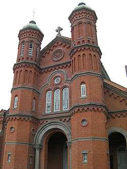
Imamura Catholic Church | |
 Location of Tachiarai in Fukuoka Prefecture | |
 Tachiarai Location in Japan | |
| Coordinates: 33°22′N 130°37′E / 33.367°N 130.617°ECoordinates: 33°22′N 130°37′E / 33.367°N 130.617°E | |
| Country | Japan |
| Region | Kyushu |
| Prefecture | Fukuoka Prefecture |
| District | Mii |
| Area | |
| • Total | 22.83 km2 (8.81 sq mi) |
| Population (Jury 1, 2008) | |
| • Total | 15,433 |
| • Density | 676/km2 (1,750/sq mi) |
| Symbols | |
| • Tree | Ilex integra |
| • Flower | Cherry blossom |
| • Bird | Skylark |
| Time zone | Japan Standard Time (UTC+9) |
| City hall address |
819 Tomita, Tachiarai-machi, Mii-gun, Fukuoka-ken 830-1298 |
| Website |
www |
Tachiarai (大刀洗町 Tachiarai-machi) is a town located in Mii District, Fukuoka Prefecture, Japan.
As of 2003, it has an estimated population of 15,323 and a density of 671.18 persons per km². The total area is 22.83 km².
Tachiarai is divided into three neighborhoods: Ozeki, Hongō and Kikuchi. Much of the land is used for growing rice and other crops.
History
Imamura Catholic Church was built in 1913, although there have been hidden Christians in the area since the 16th century.[1]
Tachiarai was home to an Imperial Japanese Army Air Force Base, established in 1919 and the Tachiarai Army Flight School, established in 1940, before American bombers destroyed them in 1945.
Attractions
Education
The Tachiarai Board of Education is located near Ozeki train station, and is titled "Dream Center".
There is one junior high school and four elementary schools in Tachiarai. There are also a number of nursery schools, and one private English school.
References
External links
 Media related to Tachiarai, Fukuoka at Wikimedia Commons
- Tachiarai official website (Japanese)