List of Colorado municipalities by county
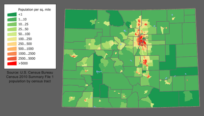
Colorado Population Density Map
The following table lists the 271 Colorado municipalities arranged by county and population.
Table
The table below presents the following information:
- The rank of the county within the state by population as of July 1, 2006, as estimated by the U.S. Census Bureau.[1]
- The official name of the county.[2]
- The county population as of July 1, 2006, as estimated by the U.S. Census Bureau.[1]
- The county population as a percentage of the Colorado state population as of July 1, 2006, as estimated by the U.S. Census Bureau.[1]
- The rank of the municipality within the county by population within the county as of July 1, 2006, as estimated by the U.S. Census Bureau.[3]
- The official name of the municipality.[4] The county seat is shown in bold.[5] If the municipality extends beyond the county, the percentage of the municipal population that resides within the county is shown.[3]
- The municipal population within the county as of July 1, 2006, as estimated by the U.S. Census Bureau.[3]
- The municipal population within the county as a percentage of the county population as of July 1, 2006, as estimated by the U.S. Census Bureau.[3]
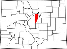
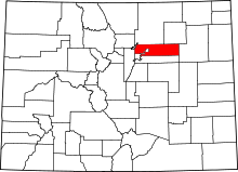
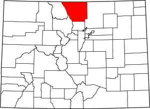
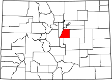
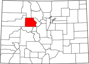
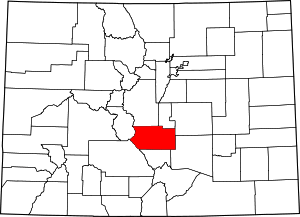
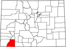
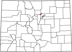
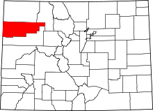
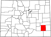
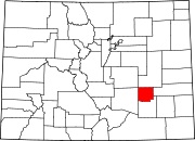
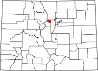
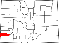
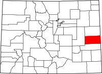
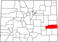
- A map showing the location of the county within the State of Colorado.[6]
Colorado Municipalities by County
| Rank |
County |
Population |
% State |
Rank |
Municipality |
Population |
% County |
Map |
|---|
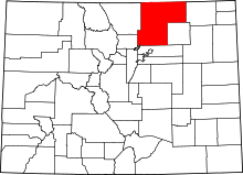
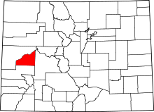
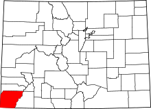
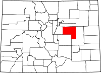
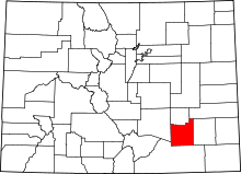
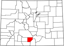
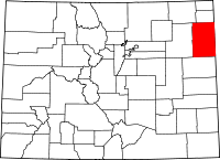
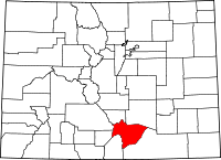
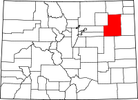
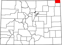
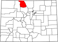
| 1 |
El Paso County |
576,884 |
12% |
1 |
City of Colorado Springs |
372,437 |
65% |
 |
| 2 |
City of Fountain |
19,374 |
3.4% |
| 3 |
City of Manitou Springs |
5,072 |
0.88% |
| 4 |
Town of Monument |
2,533 |
0.44% |
| 5 |
Town of Palmer Lake |
2,292 |
0.40% |
| 6 |
Town of Calhan |
869 |
0.15% |
| 7 |
Town of Green Mountain Falls (93.6%) |
740 |
0.13% |
| 8 |
Town of Ramah |
119 |
0.021% |
| U |
unincorporated area |
173,448 |
30% |
| 2 |
City and County of Denver |
566,974 |
12% |
1 |
City and County of Denver |
566,974 |
100% |
 |
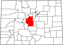
| 3 |
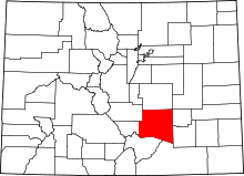
Arapahoe County |
537,197 |
11% |
1 |
City of Aurora (85%) |
259,177 |
48% |
 |
| 2 |
City of Centennial |
98,270 |
18% |
| 3 |
City of Littleton (99.46%) |
40,106 |
7.5% |
| 4 |
City of Englewood |
32,286 |
6.0% |
| 5 |
City of Greenwood Village |
13,440 |
2.5% |
| 6 |
City of Cherry Hills Village |
6,185 |
1.2% |
| 7 |
City of Sheridan |
5,460 |
1.0% |
| 8 |
City of Glendale |
4,762 |
0.89% |
| 9 |
Town of Columbine Valley |
1,254 |
0.23% |
| 10 |
Town of Foxfield |
909 |
0.17% |
| 11 |
Town of Bow Mar (72%) |
584 |
0.11% |
| 12 |
Town of Deer Trail |
578 |
0.11% |
| 13 |
Town of Bennett (6.6%) |
169 |
0.031% |
| U |
unincorporated area |
72,368 |
13% |
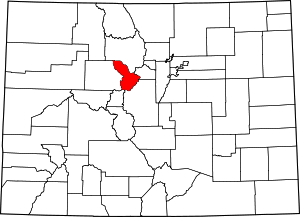
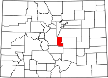
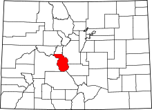
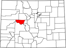
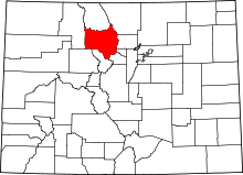
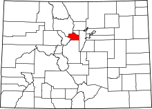
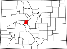
| 4 |
Jefferson County |
526,994 |
11% |
1 |
City of Lakewood |
140,024 |
27% |
 |
| 2 |
City of Arvada (97.1%) |
101,827 |
19% |
| 3 |
City of Westminster (43%) |
45,845 |
8.7% |
| 4 |
City of Wheat Ridge |
30,979 |
5.9% |
| 5 |
City of Golden |
17,239 |
3.3% |
| 6 |
City of Edgewater |
5,159 |
0.98% |
| 7 |
Town of Mountain View |
523 |
0.099% |
| 8 |
Town of Morrison |
407 |
0.077% |
| 9 |
Town of Bow Mar (28%) |
227 |
0.043% |
| 10 |
City of Littleton (0.33%) |
135 |
0.026% |
| 11 |
Town of Superior (0.42%) |
43 |
0.0082% |
| 12 |
Town of Lakeside |
19 |
0.0036% |
| U |
unincorporated area |
184,567 |
35% |
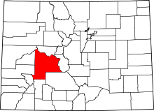
| 5 |
Adams County |
414,338 |
8.7% |
1 |
City of Thornton (99.9954%) |
109,150 |
26% |
 |
| 2 |
City of Westminster (57%) |
59,908 |
14% |
| 3 |
City of Aurora (15%) |
44,320 |
11% |
| 4 |
City of Commerce City |
38,887 |
9.4% |
| 5 |
City of Northglenn (99.33%) |
32,825 |
7.9% |
| 6 |
City of Brighton (97.6%) |
29,029 |
7.0% |
| 7 |
City of Federal Heights |
11,744 |
2.8% |
| 8 |
City of Arvada (2.9%) |
3,003 |
0.72% |
| 9 |
Town of Bennett (93.4%) |
2,401 |
0.58% |
| U |
unincorporated area |
82,765 |
20% |
| 6 |
Boulder County |
282,304 |
5.9% |
1 |
City of Boulder |
91,481 |
32% |
 |
| 2 |
City of Longmont (99.48%) |
82,216 |
29% |
| 3 |
City of Lafayette |
24,211 |
8.6% |
| 4 |
City of Louisville |
18,417 |
6.5% |
| 5 |
Town of Superior (99.58%) |
10,219 |
3.6% |
| 6 |
Town of Erie (59%) |
8,359 |
3.0% |
| 7 |
Town of Lyons |
1,756 |
0.62% |
| 8 |
Town of Nederland |
1,332 |
0.47% |
| 9 |
Town of Jamestown |
232 |
0.082% |
| 10 |
Town of Ward |
165 |
0.058% |
| U |
unincorporated area |
43,916 |
16% |
| 7 |
Larimer County |
276,253 |
5.8% |
1 |
City of Fort Collins |
129,467 |
47% |
 |
| 2 |
City of Loveland |
61,122 |
22% |
| 3 |
Town of Estes Park |
6,006 |
2.2% |
| 4 |
Town of Berthoud (96.4%) |
4,936 |
1.8% |
| 5 |
Town of Wellington |
4,128 |
1.5% |
| 6 |
Town of Windsor (7.5%) |
1,206 |
0.44% |
| 7 |
Town of Johnstown (9.2%) |
755 |
0.27% |
| 8 |
Town of Timnath |
213 |
0.077% |
| U |
unincorporated area |
68,420 |
25% |
| 8 |
Douglas County |
263,621 |
5.5% |
1 |
Town of Parker |
41,406 |
16% |
 |
| 2 |
Town of Castle Rock |
39,682 |
15% |
| NA |
City of Castle Pines North[7] |
NA |
NA |
| 3 |
City of Lone Tree |
9,003 |
3.4% |
| 4 |
Town of Larkspur |
316 |
0.12% |
| 5 |
City of Aurora (0.028%) |
85 |
0.032% |
| 6 |
City of Littleton (0.21%) |
83 |
0.031% |
| U |
unincorporated area |
173,046 |
66% |
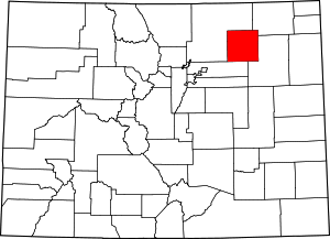
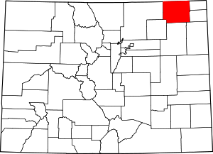
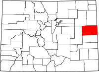
| 9 |
Weld County |
236,857 |
5.0% |
1 |
City of Greeley |
89,046 |
38% |
 |
| 2 |
City of Evans |
17,977 |
7.6% |
| 3 |
Town of Windsor (92.5%) |
14,770 |
6.2% |
| 4 |
Town of Johnstown (90.8%) |
7,482 |
3.2% |
| 5 |
City of Fort Lupton |
7,424 |
3.1% |
| 6 |
Town of Frederick |
7,395 |
3.1% |
| 7 |
Town of Firestone |
7,124 |
3.0% |
| 8 |
Town of Milliken |
5,801 |
2.4% |
| 9 |
Town of Erie (41%) |
5,766 |
2.4% |
| 10 |
Town of Eaton |
4,044 |
1.7% |
| 11 |
Town of Lochbuie |
4,033 |
1.7% |
| 12 |
City of Dacono |
3,752 |
1.6% |
| 13 |
Town of Mead |
2,849 |
1.2% |
| 14 |
Town of Platteville |
2,611 |
1.1% |
| 15 |
Town of Severance |
2,590 |
1.1% |
| 16 |
Town of LaSalle |
1,916 |
0.81% |
| 17 |
Town of Hudson |
1,582 |
0.67% |
| 18 |
Town of Ault |
1,420 |
0.60% |
| 19 |
Town of Kersey |
1,418 |
0.60% |
| 20 |
Town of Keenesburg |
1,140 |
0.48% |
| 21 |
Town of Gilcrest |
1,139 |
0.48% |
| 22 |
Town of Pierce |
864 |
0.36% |
| 23 |
City of Brighton (2.4%) |
721 |
0.30% |
| 24 |
Town of Nunn |
524 |
0.22% |
| 25 |
City of Longmont (0.52%) |
430 |
0.18% |
| 26 |
Town of Garden City |
339 |
0.14% |
| 27 |
City of Northglenn (0.67%) |
220 |
0.093% |
| 28 |
Town of Berthoud (3.6%) |
184 |
0.078% |
| 29 |
Town of Grover |
153 |
0.065% |
| 30 |
Town of Raymer |
91 |
0.038% |
| 31 |
City of Thornton (0.0046%) |
5 |
0.0021% |
| U |
unincorporated area |
42,047 |
18% |
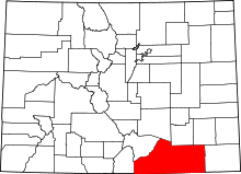
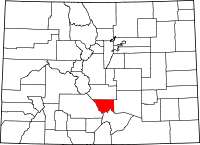
| 10 |
Pueblo County |
152,912 |
3.2% |
1 |
City of Pueblo |
103,730 |
68% |
 |
| 2 |
Town of Boone |
333 |
0.22% |
| 3 |
Town of Rye |
203 |
0.13% |
| U |
unincorporated area |
48,646 |
32% |
| 11 |
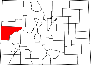
Mesa County |
134,189 |
2.8% |
1 |
City of Grand Junction |
46,898 |
35% |
 |
| 2 |
City of Fruita |
7,055 |
5.3% |
| 3 |
Town of Palisade |
2,734 |
2.0% |
| 4 |
Town of De Beque |
481 |
0.36% |
| 5 |
Town of Collbran |
415 |
0.31% |
| U |
unincorporated area |
76,606 |
57% |
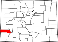
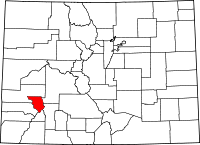
| 12 |
Garfield County |
51,908 |
1.1% |
1 |
City of Glenwood Springs |
8,765 |
17% |
 |
| 2 |
City of Rifle |
8,446 |
16% |
| 3 |
Town of Carbondale |
6,013 |
12% |
| 4 |
Town of New Castle |
3,294 |
6.3% |
| 5 |
Town of Silt |
2,408 |
4.6% |
| 6 |
Town of Parachute |
1,189 |
2.3% |
| U |
unincorporated area |
21,793 |
42% |
| 13 |
Eagle County |
49,085 |
1.0% |
1 |
Town of Avon |
6,399 |
13% |
 |
| 2 |
Town of Gypsum |
5,307 |
11% |
| 3 |
Town of Eagle |
4,919 |
10% |
| 4 |
Town of Vail |
4,628 |
9.4% |
| 5 |
Town of Basalt (73%) |
2,220 |
4.5% |
| 6 |
Town of Minturn |
1,132 |
2.3% |
| 7 |
Town of Red Cliff |
307 |
0.63% |
| U |
unincorporated area |
24,173 |
49% |
| 14 |
Fremont County |
48,010 |
1.0% |
1 |
City of Cañon City |
16,124 |
34% |
 |
| 2 |
City of Florence |
3,692 |
7.7% |
| 3 |
Town of Williamsburg |
756 |
1.6% |
| 4 |
Town of Rockvale |
443 |
0.92% |
| 5 |
Town of Coal Creek |
362 |
0.75% |
| 6 |
Town of Brookside |
219 |
0.46% |
| U |
unincorporated area |
26,414 |
55% |
| 15 |
La Plata County |
47,936 |
1.0% |
1 |
City of Durango |
15,614 |
33% |
 |
| 2 |
Town of Bayfield |
1,792 |
3.7% |
| 3 |
Town of Ignacio |
630 |
1.3% |
| U |
unincorporated area |
29,900 |
62% |
| 16 |
City and County of Broomfield |
45,116 |
0.95% |
1 |
City and County of Broomfield |
45,116 |
100% |
 |
| 17 |
Montrose County |
38,559 |
0.81% |
1 |
City of Montrose |
16,449 |
43% |
 |
| 2 |
Town of Olathe |
1,721 |
4.5% |
| 3 |
Town of Nucla |
733 |
1.9% |
| 4 |
Town of Naturita |
659 |
1.7% |
| U |
unincorporated area |
18,997 |
49% |
| 18 |
Delta County |
30,401 |
0.64% |
1 |
City of Delta |
8,366 |
28% |
 |
| 2 |
Town of Orchard City |
3,133 |
10% |
| 3 |
Town of Cedaredge |
2,215 |
7.3% |
| 4 |
Town of Paonia |
1,621 |
5.3% |
| 5 |
Town of Hotchkiss |
1,087 |
3.6% |
| 6 |
Town of Crawford |
389 |
1.3% |
| U |
unincorporated area |
13,590 |
45% |
| 19 |
Morgan County |
28,109 |
0.59% |
1 |
City of Fort Morgan |
10,807 |
38% |
 |
| 2 |
City of Brush |
5,205 |
19% |
| 3 |
Town of Log Lane Village |
1,010 |
3.6% |
| 4 |
Town of Wiggins |
944 |
3.4% |
| 5 |
Town of Hillrose |
278 |
0.99% |
| U |
unincorporated area |
9,865 |
35% |
| 20 |
Summit County |
25,399 |
0.53% |
1 |
Town of Silverthorne |
3,733 |
15% |
 |
| 2 |
Town of Breckenridge |
2,768 |
11% |
| 3 |
Town of Frisco |
2,498 |
9.8% |
| 4 |
Town of Blue River |
864 |
3.4% |
| 5 |
Town of Dillon |
780 |
3.1% |
| 6 |
Town of Montezuma |
42 |
0.17% |
| U |
unincorporated area |
14,714 |
58% |
| 21 |
Montezuma County |
25,217 |
0.53% |
1 |
City of Cortez |
8,448 |
34% |
 |
| 2 |
Town of Mancos |
1,226 |
4.9% |
| 3 |
Town of Dolores |
899 |
3.6% |
| U |
unincorporated area |
14,644 |
58% |
| 22 |
Elbert County |
23,181 |
0.49% |
1 |
Town of Elizabeth |
1,501 |
6.5% |
 |
| 2 |
Town of Simla |
720 |
3.1% |
| 3 |
Town of Kiowa |
607 |
2.6% |
| U |
unincorporated area |
20,353 |
88% |
| 23 |
Teller County |
22,243 |
0.47% |
1 |
City of Woodland Park |
6,729 |
30% |
 |
| 2 |
City of Cripple Creek |
1,068 |
4.8% |
| 3 |
City of Victor |
422 |
1.9% |
| 4 |
Town of Green Mountain Falls (6.4%) |
51 |
0.23% |
| U |
unincorporated area |
13,973 |
63% |
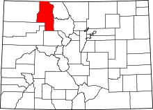
| 24 |
Routt County |
21,580 |
0.45% |
1 |
City of Steamboat Springs |
9,315 |
43% |
 |
| 2 |
Town of Hayden |
1,534 |
7.1% |
| 3 |
Town of Oak Creek |
791 |
3.7% |
| 4 |
Town of Yampa |
413 |
1.9% |
| U |
unincorporated area |
9,527 |
44% |
| 25 |
Logan County |
20,780 |
0.44% |
1 |
City of Sterling |
12,581 |
61% |
 |
| 2 |
Town of Fleming |
442 |
2.1% |
| 3 |
Town of Merino |
278 |
1.3% |
| 4 |
Town of Peetz |
224 |
1.1% |
| 5 |
Town of Iliff |
222 |
1.1% |
| 6 |
Town of Crook |
128 |
0.62% |
| U |
unincorporated area |
6,905 |
33% |
| 26 |
Otero County |
19,452 |
0.41% |
1 |
City of La Junta |
7,242 |
37% |
 |
| 2 |
City of Rocky Ford |
4,118 |
21% |
| 3 |
Town of Fowler |
1,134 |
5.8% |
| 4 |
Town of Swink |
681 |
3.5% |
| 5 |
Town of Manzanola |
494 |
2.5% |
| 6 |
Town of Cheraw |
211 |
1.1% |
| U |
unincorporated area |
5,572 |
29% |
| 27 |
Park County |
17,157 |
0.36% |
1 |
Town of Fairplay |
678 |
4.0% |
 |
| 2 |
Town of Alma |
181 |
1.1% |
| U |
unincorporated area |
16,298 |
95.0% |
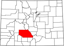
| 28 |
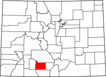
Chaffee County |
16,918 |
0.35% |
1 |
City of Salida |
5,410 |
32% |
 |
| 2 |
Town of Buena Vista |
2,155 |
13% |
| 3 |
Town of Poncha Springs |
461 |
2.7% |
| U |
unincorporated area |
8,892 |
53% |
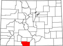
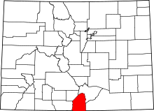
| 29 |
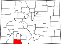
Las Animas County |
15,564 |
0.33% |
1 |
City of Trinidad |
9,134 |
59% |
 |
| 2 |
Town of Aguilar |
578 |
3.7% |
| 3 |
Town of Cokedale |
135 |
0.87% |
| 4 |
Town of Starkville |
130 |
0.84% |
| 5 |
Town of Branson |
79 |
0.51% |
| 6 |
Town of Kim |
66 |
0.42% |
| U |
unincorporated area |
5,442 |
35% |
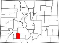
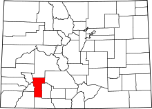
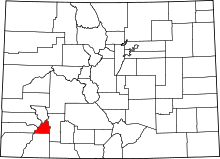
| 30 |
Alamosa County |
15,225 |
0.32% |
1 |
City of Alamosa |
8,679 |
57% |
 |
| 2 |
Town of Hooper |
125 |
0.82% |
| U |
unincorporated area |
6,421 |
42% |
| 31 |
Pitkin County |
14,798 |
0.31% |
1 |
City of Aspen |
5,728 |
39% |
 |
| 2 |
Town of Snowmass Village |
1,741 |
12% |
| 3 |
Town of Basalt (27%) |
821 |
5.5% |
| U |
unincorporated area |
6,508 |
44% |
| 32 |
Gunnison County |
14,331 |
0.30% |
1 |
City of Gunnison |
5,309 |
37% |
 |
| 2 |
Town of Crested Butte |
1,554 |
11% |
| 3 |
Town of Mount Crested Butte |
765 |
5.3% |
| 4 |
Town of Pitkin |
113 |
0.79% |
| 5 |
Town of Marble |
100 |
0.70% |
| U |
unincorporated area |
6,490 |
45% |
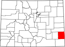
| 33 |
Prowers County |
13,776 |
0.29% |
1 |
City of Lamar |
8,356 |
61% |
 |
| 2 |
Town of Holly |
987 |
7.2% |
| 3 |
Town of Granada |
612 |
4.4% |
| 4 |
Town of Wiley |
470 |
3.4% |
| 5 |
Town of Hartman |
108 |
0.78% |
| U |
unincorporated area |
3,243 |
24% |
| 34 |
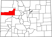
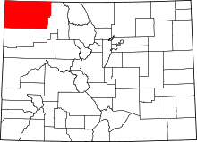
Moffat County |
13,680 |
0.29% |
1 |
City of Craig |
9,251 |
68% |
 |
| 2 |
Town of Dinosaur |
342 |
2.5% |
| U |
unincorporated area |
4,087 |
30% |
| 35 |
Grand County |
13,406 |
0.28% |
1 |
Town of Granby |
1,674 |
12% |
 |
| 2 |
Town of Kremmling |
1,549 |
12% |
| 3 |
Town of Fraser |
899 |
6.7% |
| 4 |
Town of Winter Park |
717 |
5.3% |
| 5 |
Town of Hot Sulphur Springs |
518 |
3.9% |
| 6 |
Town of Grand Lake |
437 |
3.3% |
| U |
unincorporated area |
7,612 |
57% |
| 36 |
Archuleta County |
12,386 |
0.26% |
1 |
Town of Pagosa Springs |
1,684 |
14% |
 |
| U |
unincorporated area |
10,702 |
86% |
| 37 |
Rio Grande County |
12,006 |
0.25% |
1 |
City of Monte Vista |
4,159 |
35% |
 |
| 2 |
Town of Del Norte |
1,685 |
14% |
| 3 |
Town of South Fork |
558 |
4.6% |
| 4 |
Town of Center (1.1%) |
26 |
0.22% |
| U |
unincorporated area |
5,578 |
46% |
| 38 |
Yuma County |
9,829 |
0.21% |
1 |
City of Yuma |
3,249 |
33% |
 |
| 2 |
City of Wray |
2,160 |
22% |
| 3 |
Town of Eckley |
273 |
2.8% |
| U |
unincorporated area |
4,147 |
42% |
| 39 |
Clear Creek County |
9,130 |
0.19% |
1 |
City of Idaho Springs |
1,797 |
20% |
 |
| 2 |
Town of Georgetown |
1,054 |
12% |
| 3 |
Town of Empire |
335 |
3.7% |
| 4 |
Town of Silver Plume |
190 |
2.1% |
| 5 |
Central City (0.58%) |
3 |
0.033% |
| U |
unincorporated area |
5,751 |
63% |
| 40 |
Conejos County |
8,406 |
0.18% |
1 |
Town of Manassa |
1,001 |
12% |
 |
| 2 |
Town of Antonito |
832 |
9.9% |
| 3 |
Town of La Jara |
823 |
9.8% |
| 4 |
Town of Sanford |
784 |
9.3% |
| 5 |
Town of Romeo |
363 |
4.3% |
| U |
unincorporated area |
4,603 |
55% |
| 41 |
Lake County |
7,814 |
0.16% |
1 |
City of Leadville |
2,705 |
35% |
 |
| U |
unincorporated area |
5,109 |
65% |
| 42 |
Huerfano County |
7,808 |
0.16% |
1 |
City of Walsenburg |
3,943 |
50% |
 |
| 2 |
Town of La Veta |
887 |
11% |
| U |
unincorporated area |
2,978 |
38% |
| 43 |
Kit Carson County |
7,590 |
0.16% |
1 |
City of Burlington |
3,480 |
46% |
 |
| 2 |
Town of Stratton |
627 |
8.3% |
| 3 |
Town of Flagler |
586 |
7.7% |
| 4 |
Town of Bethune |
215 |
2.8% |
| 5 |
Town of Seibert |
171 |
2.3% |
| 6 |
Town of Vona |
90 |
1.2% |
| U |
unincorporated area |
2,421 |
32% |
| 44 |
San Miguel County |
7,143 |
0.15% |
1 |
Town of Telluride |
2,267 |
32% |
 |
| 2 |
Town of Mountain Village |
1,195 |
17% |
| 3 |
Town of Norwood |
445 |
6.2% |
| 4 |
Town of Ophir |
124 |
1.7% |
| 5 |
Town of Sawpit |
23 |
0.32% |
| U |
unincorporated area |
3,089 |
43% |
| 45 |
Saguache County |
7,006 |
0.15% |
1 |
Town of Center (98.9%) |
2,419 |
35% |
 |
| 2 |
Town of Saguache |
595 |
8.5% |
| 3 |
Town of Moffat |
122 |
1.7% |
| 4 |
Town of Crestone |
86 |
1.2% |
| 5 |
Town of Bonanza |
15 |
0.21% |
| U |
unincorporated area |
3,769 |
54% |
| 46 |
Rio Blanco County |
6,180 |
0.13% |
1 |
Town of Meeker |
2,300 |
37% |
 |
| 2 |
Town of Rangely |
2,090 |
34% |
| U |
unincorporated area |
1,790 |
29% |
| 47 |
Bent County |
5,551 |
0.12% |
1 |
City of Las Animas |
2,531 |
46% |
 |
| U |
unincorporated area |
3,020 |
54% |
| 48 |
Lincoln County |
5,458 |
0.11% |
1 |
Town of Limon |
1,817 |
33% |
 |
| 2 |
Town of Hugo |
771 |
14% |
| 3 |
Town of Arriba |
217 |
4.0% |
| 4 |
Town of Genoa |
187 |
3.4% |
| U |
unincorporated area |
2,466 |
45% |
| 49 |
Crowley County |
5,386 |
0.11% |
1 |
Town of Ordway |
1,174 |
22% |
 |
| 2 |
Town of Olney Springs |
373 |
6.9% |
| 3 |
Town of Sugar City |
263 |
4.9% |
| 4 |
Town of Crowley |
178 |
3.3% |
| U |
unincorporated area |
3,398 |
63% |
| 50 |
Gilpin County |
5,042 |
0.11% |
1 |
Central City (99.42%) |
511 |
10% |
 |
| 2 |
City of Black Hawk |
107 |
2.1% |
| U |
unincorporated area |
4,424 |
88% |
| 51 |
Washington County |
4,630 |
0.097% |
1 |
Town of Akron |
1,573 |
34% |
 |
| 2 |
Town of Otis |
509 |
11% |
| U |
unincorporated area |
2,548 |
55% |
| 52 |
Phillips County |
4,601 |
0.097% |
1 |
City of Holyoke |
2,291 |
50% |
 |
| 2 |
Town of Haxtun |
997 |
22% |
| 3 |
Town of Paoli |
42 |
0.91% |
| U |
unincorporated area |
1,271 |
28% |
| 53 |
Ouray County |
4,307 |
0.090% |
1 |
City of Ouray |
896 |
21% |
 |
| 2 |
Town of Ridgway |
749 |
17% |
| U |
unincorporated area |
2,662 |
62% |
| 54 |
Baca County |
4,017 |
0.084% |
1 |
Town of Springfield |
1,350 |
34% |
 |
| 2 |
Town of Walsh |
667 |
17% |
| 3 |
Town of Campo |
133 |
3.3% |
| 4 |
Town of Pritchett |
122 |
3.0% |
| 5 |
Town of Vilas |
99 |
2.5% |
| 6 |
Town of Two Buttes |
60 |
1.5% |
| U |
unincorporated area |
1,586 |
39% |
| 55 |
Custer County |
3,926 |
0.082% |
1 |
Town of Silver Cliff |
582 |
15% |
 |
| 2 |
Town of Westcliffe |
456 |
12% |
| U |
unincorporated area |
2,888 |
74% |
| 56 |
Costilla County |
3,378 |
0.071% |
1 |
Town of San Luis |
680 |
20% |
 |
| 2 |
Town of Blanca |
363 |
11% |
| U |
unincorporated area |
2,335 |
69% |
| 57 |
Sedgwick County |
2,467 |
0.052% |
1 |
Town of Julesburg |
1,308 |
53% |
 |
| 2 |
Town of Ovid |
306 |
12% |
| 3 |
Town of Sedgwick |
171 |
6.9% |
| U |
unincorporated area |
682 |
28% |
| 58 |
Dolores County |
1,911 |
0.040% |
1 |
Town of Dove Creek |
711 |
37% |
 |
| 2 |
Town of Rico |
241 |
13% |
| U |
unincorporated area |
959 |
50% |
| 59 |
Cheyenne County |
1,906 |
0.040% |
1 |
Town of Cheyenne Wells |
856 |
45% |
 |
| 2 |
Town of Kit Carson |
219 |
11% |
| U |
unincorporated area |
831 |
44% |
| 60 |
Kiowa County |
1,413 |
0.030% |
1 |
Town of Eads |
647 |
46% |
 |
| 2 |
Town of Haswell |
75 |
5.3% |
| 3 |
Town of Sheridan Lake |
60 |
4.2% |
| U |
unincorporated area |
631 |
45% |
| 61 |
Jackson County |
1,406 |
0.029% |
1 |
Town of Walden |
621 |
44% |
 |
| U |
unincorporated area |
785 |
56% |
| 62 |
Mineral County |
929 |
0.019% |
1 |
Town of Creede |
409 |
44% |
 |
| U |
unincorporated area |
520 |
56% |
| 63 |
Hinsdale County |
819 |
0.017% |
1 |
Town of Lake City |
383 |
47% |
 |
| U |
unincorporated area |
436 |
53% |
| 64 |
San Juan County |
578 |
0.012% |
1 |
Town of Silverton |
548 |
94.8% |
 |
| U |
unincorporated area |
30 |
5.2% |
|
See also
References
- 1 2 3 "Annual County Population Estimates and Estimated Components of Change: April 1, 2000 to July 1, 2006" (CSV). 2006 Population Estimates. United States Census Bureau, Population Division. 2007-03-22. Retrieved 2008-01-16.
- ↑ "Colorado Counties as of January 15, 2008 (64 counties)". State of Colorado, Department of Local Affairs. 2008-01-15. Retrieved 2008-01-16.
- 1 2 3 4 "Colorado Subcounty Population Estimates: April 1, 2000 to July 1, 2006" (CSV). 2006 Population Estimates. United States Census Bureau, Population Division. 2007-06-27. Retrieved 2008-01-16.
- ↑ "Active Colorado Municipalities as of January 15, 2008 (270 municipalities)". State of Colorado, Department of Local Affairs. 2008-01-15. Retrieved 2008-01-16.
- ↑ "Colorado County Seats". State of Colorado, Department of Public Health and Environment. Retrieved 2008-01-16.
- ↑ "Map of the State of Colorado" (PDF). State of Colorado, Department of Transportation. 2007-05-01. Retrieved 2008-01-16.
- ↑ Ivan Moreno (2006-11-06). "Castle Pines North incorporates". Rocky Mountain News. Retrieved 2008-01-16.
External links
