Table Rock State Park (South Carolina)
| Table Rock State Park | |
|---|---|
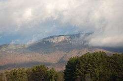 Table Rock Mountain | |
| Nearest city | Pickens, South Carolina |
| Coordinates | 35°02′09.2″N 82°42′21.3″W / 35.035889°N 82.705917°WCoordinates: 35°02′09.2″N 82°42′21.3″W / 35.035889°N 82.705917°W |
| Area | 3,083 acres (12.5 km2) |
| Created | 1935[1] |
| Camp sites | Both regular and RV campsites[2] Mountain cabins are also available in the park[3] |
| Hiking trails |
|
| Other information | Pets are allowed everywhere, except the cabin areas, as long as they're on a leash |
| Website | Table Rock State Park |
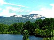
Table Rock State Park is a 3,083-acre (12.48 km2) park at the edge of the Blue Ridge Mountains in northern Pickens County, South Carolina. The park includes Pinnacle Mountain, the tallest mountain totally within the state.[4]
Park Features
The park features a lodge restored by the Civilian Conservation Corps (CCC) that includes a kitchen and a 72-seat dining room.[5] There are two park lakes with seasonal swimming permitted and hiking trails that lead to the Pinnacle Mountain Summit (two routes), Mill Creek Falls, and the summit of Table Rock. A nature center offers educational programs, and there are picnic shelters and a playground.
Trails
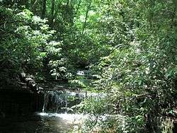
The 1.9-mile (3.1 km) Carrick Creek Nature Trail loops around two creeks with small cascades and waterfalls and displays wildflowers in season.[6]
The 3.5-mile (5.6 km) Table Rock Summit Trail is moderately strenuous, rising 2,000 feet (610 m) above the trailhead and includes a shelter built by the CCC. At approximately 2.5 miles (4.0 km), the trail forks, the left fork following a ridge trail to Pinnacle Mountain and the right fork to the summit at 3,124 feet (952 m). The trail ends at an overlook with a view of Table Rock Reservoir and Caesars Head.[7]
The park is the eastern trailhead of the 80-mile (130 km) Foothills Trail through the Blue Ridge Escarpment.
History
Prior to the signing of the Hopewell Treaty of 1785, the land now encompassed by Table Rock State Park was part of the Lower Cherokee Nation. The Cherokee called the area, "Sah-ka-na-ga," the Great Blue Hills of God, and they established many hunting camps in the area.[8]
Europeans moved into the Oolenoy River Valley soon after the signing of the Hopewell Treaty, settling at Pumpkintown (named for the unusually large pumpkins grown there). William Sutherland and James Keith operated a wayside lodge for visitors and in about 1840, they built a hotel, which prospered until the Civil War. Visitors increased again after Reconstruction, and in 1899, E. Foster Keith built a new hotel, which was later destroyed. By the beginning of the 20th century several farm families lived in the Table Rock area.[8]
Table Rock State Park Historic District
|
Table Rock State Park Historic District | |
  | |
| Nearest city | Pickens, South Carolina |
|---|---|
| Area | 2,860 acres (1,160 ha) |
| Architectural style | Late 19th And Early 20th Century American Movements, Other, CCC construction |
| MPS | South Carolina State Parks MPS |
| NRHP Reference # | 89000478[9] |
| Added to NRHP | June 15, 1989 |
In 1935 approximately 2,860 acres (11.6 km2) of land was donated by Pickens County and the city of Greenville.[10][11] The park was built in the 1930s by the Civilian Conservation Corps.[12] The CCC built a dam for Pinnacle Lake, several fish-rearing pools, the superintendent's residence, a lodge, shelters, and miles of roads and hiking trails. The CCC also landscaped the park using natural vegetation from the Pinnacle Lake bed. Much of this work remains visible in the 21st century.[8]
The Table Rock State Park Historic District is listed on the National Register of Historic Places in 1989.[9] Also listed in 1989 were the related Civilian Conservation Corps Quarry No. 1 and Truck Trail, Civilian Conservation Corps Quarry No. 2, Roper House Complex and Table Rock Civilian Conservation Corps Camp Site. It is also a South Carolina Heritage Trust Site.
References
- ↑ "About This Park - Table Rock State Park - South Carolina State Parks". 14 October 2007.
- ↑ "Table Rock State Park - (near) Pickens". 14 October 2007.
- ↑ " "About This Park - Table Rock State Park - South Carolina State Parks". 14 October 2007.
- ↑ "South Carolina - Naturally!". 9 May 2007..
- ↑ SC State Park website
- ↑ SC Hiking Trails website
- ↑ "Table Rock State Park Map" (PDF). 10 October 2010..
- 1 2 3 Table Rock State Park sign (May 30, 2009).
- 1 2 National Park Service (2010-07-09). "National Register Information System". National Register of Historic Places. National Park Service.
- ↑ Sims, E. Thomas; Julie Turner (February 1, 1989). "Table Rock State Park (CCC) Camp Site" (pdf). National Register of Historic Places - Nomination and Inventory. Retrieved 29 July 2012.
- ↑ "Table Rock State Park CCC Camp Site, Pickens County (off S.C. Sec. Rd. 25, Pickens vicinity)". National Register Properties in South Carolina. South Carolina Department of Archives and History. Retrieved 29 July 2012.
- ↑ "About This Park - Table Rock State Park - South Carolina State Parks". 14 October 2007. In 1975 to 1976, 208 acres were purchased from various owners. In 1991, 15 acres were donated by Elizabeth Ellison.
External links
-
 Media related to Table Rock State Park at Wikimedia Commons
 -
 Geographic data related to Table Rock State Park (South Carolina) at OpenStreetMap
 - Table Rock State Park - official site
| Topics |   | |
|---|---|---|
| Lists by county |
| |
| Lists by city | ||
| Other lists | ||