Szczawa, Lesser Poland Voivodeship
| Szczawa | |
|---|---|
| Village | |
|
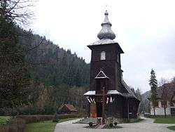
Wooden church | |
 Szczawa | |
| Coordinates: 49°36′25″N 20°17′51″E / 49.60694°N 20.29750°ECoordinates: 49°36′25″N 20°17′51″E / 49.60694°N 20.29750°E | |
| Country |
|
| Voivodeship | Lesser Poland |
| County | Limanowa |
| Gmina | Kamienica |
| Highest elevation | 1,008 m (3,307 ft) |
| Lowest elevation | 530 m (1,740 ft) |
| Population | 2,100 |
| Website | http://www.szczawa.prv.pl |
Szczawa [ˈʂt͡ʂava] is a village in the administrative district of Gmina Kamienica, within Limanowa County, Lesser Poland Voivodeship, in southern Poland. It lies approximately 5 kilometres (3 mi) north-west of Kamienica, 15 km (9 mi) south-west of Limanowa, and 58 km (36 mi) south-east of the regional capital Kraków.[1]
The village has a population of 2,100. Szczawa is a recreational village and winter sports destination located in the valley of Gorce Mountains beneath the Gorce National Park.[2]
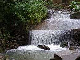
The Głębieniec river waterfall in Szczawa
References
- ↑ "Central Statistical Office (GUS) – TERYT (National Register of Territorial Land Apportionment Journal)" (in Polish). 2008-06-01.
- ↑ Marek Cieszkowski (2004). "W sercu Beskidów. Geografia i przyroda Gorców (In the Heart of Beskids. Geography and Botany of Gorce)". Gorce: przewodnik dla prawdziwego turysty (Gorce: Guide for a Qualified Tourist). Oficyna Wydawnicza "Rewasz". pp. 17–32. ISBN 8389188198. Retrieved January 9, 2013.
This article is issued from Wikipedia - version of the 4/22/2014. The text is available under the Creative Commons Attribution/Share Alike but additional terms may apply for the media files.