Jordan–Syria border
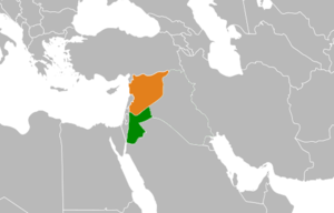
The border between Syria and Jordan measures 375 km.[1] It was created in 1921, with the establishment of the Emirate of Transjordan. It runs south of the Israeli-occupied Golan Heights along the Yarmouk River, and to the east, passes between Ar Ramtha and Daraa across the Daraa Border Crossing and on to the Nasib Border Crossing on the Amman–Damascus road, and further east to 32°18′40″N 36°50′18″E / 32.3112°N 36.8382°E, where it turns north-east, running in a straight line across the Syrian Desert, terminating in the Jordan–Syria–Iraq tripoint at 33°22′29″N 38°47′37″E / 33.3747°N 38.7936°E.
See also
References
This article is issued from Wikipedia - version of the 9/6/2016. The text is available under the Creative Commons Attribution/Share Alike but additional terms may apply for the media files.