Sydney Orbital Network
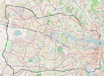
The Sydney Orbital Network is a 110 kilometre[1] motorway standard ring road or orbital around the city of Sydney, the capital of New South Wales in Australia. It runs north from Sydney Airport, underneath the CBD to the North Shore, west to the Hills District, south to Prestons and then east to connect with the airport. Much of the road is privately owned and financed by tolls.
History
Planning for this beltway, orbital or ring road began as early as 1962 under the "County of Cumberland scheme" (CCS) and well talked about as far back as 1944. Then from 1973 to 1989 things started to take shape with new sections opening-up and then further advancing by 1999. In 2007, the Lane Cove Tunnel opened, completing the orbital network.
Motorways that make up the orbital road
The 110 km Sydney orbital consists of several motorways and freeways, they are listed below:
- Eastern Distributor
- Southern Cross Drive
- General Holmes Drive
- M5 East Motorway
- M5 South Western Motorway
- Westlink M7
- M2 Hills Motorway
- Lane Cove Tunnel
- Gore Hill Freeway
- Warringah Freeway
- Sydney Harbour Tunnel (or Sydney Harbour Bridge and Cahill Expressway)
The major sunken/underground sections of the orbital are:
- Sydney Harbour Tunnel
- Eastern Distributor
- M5 East tunnel
- Epping Tunnel (M2 Hills Motorway, although not really a major tunnel)
- Sunken Section of the M2 Hills Motorway (The trench between Epping Road)
- Lane Cove Tunnel
The major elevated sections are:
- Parts of the Westlink M7
- Parts of Southern Cross and General Holmes Drive (past the airport)
The widest part of the orbital is the Warringah Freeway approach to the Sydney Harbour Bridge, the longest tunnel is the M5 East tunnel, and the largest interchange is the Light Horse Interchange between the M4 and M7, a 4-level stack. It would cost over $30AU to take the whole orbital without exiting once. The average width of the Orbital is 3 lanes in each direction (The M7 and the M5 East are 2 lanes in each direction, the Lane Cove Tunnel is mostly 3 lanes in direction, however the M2, Gore Hill Freeway and M5 are 3 lanes each way while the Warringah Freeway is between 6-8 lanes each way for its short duration of around 3km).
There is significant upgrade work occurring as part of the WestConnex project, which will see the M5 duplicated (total of 4 lanes each way) along with the addition of new freeways to the Sydney network.
Tolling
The Sydney Orbital Road Network consists of a number of roads built by private companies: tolling is unavoidable when using the road network.
| Road | Direction | Opened | Toll Collection Method | Toll Pricing | Price | Operator |
|---|---|---|---|---|---|---|
| Eastern Distributor | Northbound | 1997 | Electronic | Flat rate | $5.50 | Airport Motorways |
| M5 South Western Motorway | Both | 1992 | Electronic | Flat rate | $4.40 | Interlink Roads |
| Westlink M7 | Both | 2005 | Electronic | Distance based | $0.3673/km, $7.35 Cap | Transurban |
| M2 Hills Motorway | Both | 1997 | Electronic | Flat rate | $6.05 | Transurban |
| Lane Cove Tunnel | Both | 2007 | Electronic | Flat rate | $3.01 | Transurban |
| Sydney Harbour Bridge | Southbound | 1932 | Electronic[2] | Time based | Weekdays $3.00 (9.30am - 4pm) $4 (6.30am - 9.30am, 4pm - 7pm) $2.50 (7pm - 6.30am); Weekends $3 (8am - 8pm) $2 (8pm - 8am) | RMS |
| Sydney Harbour Tunnel | Southbound | 1992 | Electronic | Time based | Weekdays $3.00 (9.30am - 4pm) $4 (6.30am - 9.30am, 4pm - 7pm) $2.50 (7pm - 6.30am); Weekends $3 (8am - 8pm) $2 (8pm - 8am) | RMS |
Highway links
Intercity highways are linked to the Orbital, moving traffic away from the old busy National Routes. They are:
- Pennant Hills Rd - linking M1 Pacific Motorway, Newcastle and Brisbane to M2 Hills Motorway
- M4 Western Motorway - linking Great Western Highway and Bathurst to Westlink M7
- M31 Hume Motorway - linking Melbourne and Canberra to M5 South Western Motorway and Westlink M7
- King Georges Rd - linking Princes Highway, M1 Princes Motorway and Wollongong to M5 South Western Motorway
Proposed or missing freeway/motorway links
- Link to the M1 Pacific Motorway – In 2015 construction of the NorthConnex tunnel under Pennant Hills Road commenced.
- Link to the M1 Princes Motorway – At present, there are no plans to complete this link as freeway standard. The only section which was built is the Captain Cook Bridge and its approaches. Land is still reserved north of this point through Sandringham, and south through the Royal National Park. In June 2016 the Roads & Maritime Services commenced geotechnical analysis to determine underground rock and soil conditions on the former F6 corridor from Waterfall to the Sydney Orbital Network at Rockdale with a view into developing a possible link between the Princess Motorway and the Orbital Network.[3]
- WestConnex – A proposal that incorporates the M5 duplication project and the M4 East extension of the M4 Motorway to the M5 South Western Motorway, involving a cutting along Parramatta Road, a tunnel from Taveners Hill to St Peters and a surface motorway to the M5 at Arncliffe.
See also
![]() Australian roads portal
Australian roads portal
References
- ↑ RTA Website Motorways and tolling
- ↑ RTA Website The Sydney Harbour Bridge will be completely cash free from 11 January 2009.
- ↑ "Fact sheet: F6 Corridor Geotechnical Analysis" (PDF). Roads & Maritime Services. Government of New South Wales. June 2016. Retrieved 10 October 2016.