Sverdrup Islands
|
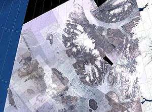
NASA Landsat photo of the Sverdrup Islands From left to right: Ellef Ringnes, Amund Ringnes, and Axel Heiberg islands. | |
_(14781596262).jpg) | |
| Geography | |
|---|---|
| Location | Arctic Ocean |
| Coordinates | 78°30′N 95°00′W / 78.500°N 95.000°WCoordinates: 78°30′N 95°00′W / 78.500°N 95.000°W |
| Archipelago |
Queen Elizabeth Islands Canadian Arctic Archipelago |
| Major islands | Axel Heiberg, Ellef Ringnes, Amund Ringnes |
| Area | 66,000 km2 (25,000 sq mi) |
| Highest elevation | 2,210 m (7,250 ft) |
| Highest point | Outlook Peak |
| Administration | |
|
Canada | |
| Territory | Nunavut |
| Region | Qikiqtaaluk |
| Demographics | |
| Population | 8 to 12 summer population |
| Pop. density | 0.000015 /km2 (3.9E-5 /sq mi) |
The Sverdrup Islands is an archipelago of the northern Queen Elizabeth Islands, in Nunavut, Canada. The islands are situated in the Arctic Ocean, west of Ellesmere Island from 77° to 81° North and 85° to 106° West.
History
The islands are named after Norwegian explorer Otto Sverdrup, who explored and mapped them from 1898 to 1902 with the vessel Fram, although some were previously inhabited by Inuit people. Sverdrup claimed the islands for Norway, but the Norwegian government showed no interest in pursuing the claim until 1928. At that point, the Norwegian government raised the claim, primarily to use the islands as bargaining chips in negotiations with the United Kingdom over the status of two other islands: the Arctic Jan Mayen and the Antarctic Bouvet Island. On 11 November 1930, Norway recognized Canadian sovereignty over the Sverdrup Islands.[1] On 19 November 1930, the UK recognized Norwegian sovereignty over Jan Mayen.[2]
Geography
The main islands of the group are Axel Heiberg Island, Ellef Ringnes Island, Amund Ringnes Island, Cornwall Island, Graham Island, Meighen Island, King Christian Island, Stor Island, and the archipelago also includes a number of smaller islands in the surrounding waters. The only habitated place was Isachsen, a formerly manned weather station, 1948 through 1978, on Ellef Ringnes Island and McGill Arctic Research Station on Axel Heiberg Island (a research station occupied during the summer).
Main Islands
| Island | Peak | Height m | Area km² | Rank Canada | Rank World |
|---|---|---|---|---|---|
| Axel Heiberg | Outlook Peak | 2,211 | 43,178 | 7 | 32 |
| Ellef Ringnes | Isachsen Dome | 260 | 11,295 | 16 | 69 |
| Amund Ringnes | ... | 265 | 5,255 | 25 | 111 |
| Meighen | Meighen Icecap | 300 | 955 | 50 | 337 |
| King Christian | King Christian Mountain | 165 | 645 | 60 | 420 |
| Stor | ... | 500 | 313 | 87 | ... |
| Sverdrup | Outlook Peak | 2,211 | 66,000 | - | - |
See also
References
- ↑ Berton, Pierre. The Arctic Grail: The Quest for the North West Passage and the North Pole. Toronto: Random House of Canada Ltd., 1988, p. 629.
- ↑ "Norsk polarhelt ville bli hemmelig agent" from aftenposten.no, 19 April 2007, in Norwegian
External links
- University of Guelph Ringnes Islands
- Nunatsiaq News - Canada secures High Arctic sovereignty
- Official site of the Fram Museum (Frammuseet)