Sutton, Ontario
| Sutton | |
|---|---|
| Unincorporated community | |
 | |
 Sutton | |
| Coordinates: 44°18′18″N 79°21′29″W / 44.30500°N 79.35806°W | |
| Country | Canada |
| Province | Ontario |
| Regional municipality | York |
| Town | Georgina |
| Demonym(s) | Suttonian |
| Time zone | EST (UTC-5) |
| • Summer (DST) | EDT (UTC-4) |
| Forward sortation area | L0E |
| Area code(s) | 905 and 289 |
| NTS Map | 031D06 |
| GNBC Code | FCUFV |
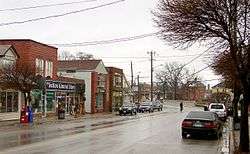
Sutton is a suburban community located nearly 2 km south of Lake Simcoe in Ontario, Canada. The community was formerly a village but is now part of the Town of Georgina after amalgamation with it and North Gwillimbury in 1971.[1][2]
Geography and information
Sutton is situated around a small river, the Black River, that flows from the south and East. Sutton is passed by a road linking Woodbine Avenue and the highway linking Toronto and Beaverton (Highway 48) forming a T junction to the southeast. The nearest superhighway is Highway 404 to the southwest. The road known as Baseline Road connects Sutton to Keswick. Sutton was once bounded with the old township of North Gwillimbury to the west. From the amalgamation, Sutton is in the central part of Georgina. The Canadian National rail runs south of Sutton and links with Toronto and Orillia as well as Northern Ontario. Sutton is located E of Keswick, about 25 to 30 km SW of Beaverton, S of Orillia, W of Lindsay, about 12 to 15 km N of Mount Albert, about 70 to 75 km N of Toronto and about 35 km NE of Newmarket.
- Population: about 5,000 (2001)
Sutton is sandwiched between forests and farmlands. A large forest dominates the south and southeast covering about 50 to 100 km² directly outside Sutton. The forest are mainly made up of pine and other varieties of trees. Farmlands cover the west and southwest dominating about 50 km² and to the east. The downtown streets are aligned at a 45° angle. Snake Island is situated to the northwest. A small bay is to the northeast.
Housing developments came in the mid-20th century to the northern part and continued slowly until the 1980s. The subdivision 2 km to the east continued in the 1980s and the early-1990s whereas each street is alphabetized from A to L. Housing projects later slowed in the 1990s and the 2000s and the population has slowed. Cottages are also found in the area located along the shore of Lake Simcoe.
Nearest places
- Keswick, west
- Mount Albert, south
- Pefferlaw, east
- Jackson's Point, north
Notes
- ↑ "Town of Georgina Historic Background Information". Town of Georgina.
- ↑ Welch, Deborah; Payne, Michael. "Georgina". The Canadian Encyclopedia.
Coordinates: 44°18′18″N 79°21′29″W / 44.30500°N 79.35806°W
Largest city: Toronto | ||
| Regions | 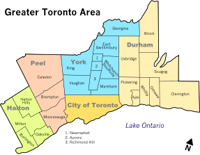 | |
| Cities | ||
| Towns | ||
| Townships and municipalities | ||