Sutter's Fort
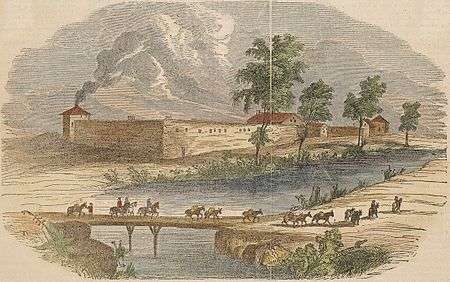
Sutter's Fort was a 19th-century agricultural and trade colony in the Mexican Alta California province.[1][2] It was built in 1839 and originally called New Helvetia (New Switzerland) by its builder John Sutter. The fort was the first non-Indigenous community in the California Central Valley.[3] The fort is famous for its association with the Donner Party, the California Gold Rush, and the formation of Sacramento. It is notable for its proximity to the end of the California Trail and Siskiyou Trails, which it served as a waystation.
After gold was discovered at Sutter's Mill (also owned by Sutter) in Coloma, the fort was abandoned.[1][4] The adobe structure has been restored to its original condition and is now administered by California Department of Parks and Recreation. It was designated a National Historic Landmark in 1961.[1]
Description
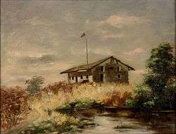
The Main Building of the fort is a two story adobe structure built between 1841 and 1843. This building is the only original surviving structure at the reconstructed Sutter's Fort State Historic Park. It was in here on January 28, 1848 that James Marshall met privately with Sutter in order to show Sutter the gold that Marshall had found during the construction of Sutter's sawmill along the American River only four days earlier. Sutter built the original fort with walls 2.5 feet (0.76 m) thick and 15 to 18 feet (5.5 m) high.[5] Pioneers took residence at Sutter's Fort around 1841. Following word of the Gold Rush, the fort was largely deserted by the 1850s and fell into disrepair.

In 1891, the Native Sons of the Golden West, who sought to safeguard many of the landmarks of California's pioneer days, purchased and rehabilitated Sutter's Fort when the City of Sacramento sought to demolish it. Repair efforts were completed in 1893 and the fort was given by the Native Sons of the Golden West to the State of California. In 1947, the fort was transferred to the authority of California State Parks.
Most of the original neighborhood structures were initially built in the late 1930s as residences, many of which have been converted to commercial uses such as private medical practices. The history of the neighborhood is largely residential.
Geography and geology

Sutter's Fort is located on level ground at an elevation of approximately 20 feet (6.1 m) above mean sea datum.[6] The slope elevation decreases northward toward the American River and westward toward the Sacramento River. Slope elevation gradually increases to the south and east, away from the rivers. All surface drainage flows toward the Sacramento River. Groundwater in the vicinity flows south-southwest toward the Sacramento Delta. However after peak rainfall, the Sacramento River swells and the groundwater flow can actually reverse away from the river.[7]
See also
- California State Indian Museum
- Old Sacramento State Historic Park
- History of Sacramento, California
- List of California State Historic Parks
- California Historical Landmarks in Sacramento County, California
- National Register of Historic Places listings in Sacramento County, California
References
- 1 2 3 National Park Service. "California National Historic Trail."
- ↑ John Sutter Biography
- ↑ Sutter's Fort State Historical Park Information
- ↑ "Sutters Fort History". Sacramento, California: California Department of Parks and Recreation. Retrieved January 17, 2012.
- ↑ Sutter's Fort Historical Profile
- ↑ U.S. Geological Survey, Sacramento East Quadrangle, 1967, photorevised 1980
- ↑ Phase I Environmental Site Assessment, 2617 K Street, Sacramento, California, Earth Metrics Inc. Report # 10185, October 3, 1989
External links
| Wikimedia Commons has media related to Sutter's Fort. |
- Sutter's Fort State Historic Park official site
- Virtual Sutter's Fort Virtual Web Site
- A History of American Indians in California: Sutter's Fort
- Library of Congress, Americas Memory
| .svg.png) | |
§ - Removed but formerly an NRHP listing. † - Shared between Yolo and Sacramento Counties. | ||