Suryapet
| Suryapet సూర్యాపేట سوریا پیٹ | |
|---|---|
| City | |
|
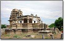
Pillalamarri, one of the oldest Hindu Temples in Suryapet | |
| Nickname(s): Bhanupuri | |
 Suryapet  Suryapet Location in Telangana, India | |
| Coordinates: 17°08′29″N 79°37′25″E / 17.1415°N 79.6236°ECoordinates: 17°08′29″N 79°37′25″E / 17.1415°N 79.6236°E | |
| Country | India |
| State | Telangana |
| District | Suryapet |
| Government | |
| • Body | Suryapet Municipality |
| • MLA | Guntakandla Jagadish Reddy (TRS) |
| Area[1] | |
| • Total | 54 km2 (21 sq mi) |
| Elevation | 571 m (1,873 ft) |
| Population (2011)[1] | |
| • Total | 105,250 |
| • Rank | 10th (in state) |
| • Density | 1,900/km2 (5,000/sq mi) |
| Languages | |
| • Official | Telugu, Urdu |
| Time zone | IST (UTC+5:30) |
| PIN | 508 213 |
| Telephone code | 91-8684 |
| Vehicle registration | TS–29 |
| Sex ratio | 1000:923 ♂/♀ |
| HDI |
|
| HDI Category | medium |
| Literacy | 84.88% |
| Website |
suryapetmunicipality |
Suryapet ![]() i/ˈsuːrjɑːpeɪtə/ is a city and the district headquarters of Suryapet district in the Indian state of Telangana.[2][3]
i/ˈsuːrjɑːpeɪtə/ is a city and the district headquarters of Suryapet district in the Indian state of Telangana.[2][3]
Etymology
The city has historical recognition as Gate Way of Telangana.[4]
Geography
Suryapet or Suriapet is located at 17°09′00″N 79°37′00″E / 17.1500°N 79.6167°E.[5] It has an area of 54 square kilometres (21 sq mi).
History
Chalukyas, Kakatiyas and Nizam dynasties ruled the region.[4]
Climate
Under the Köppen climate classification, Suryapet experiences Tropical Wet and Dry Climate. The annual mean temperature is 36 °C .Monthly mean temperatures are 19–40 °C (66–104 °F).Summers (March–June) are hot and humid, with temperatures in the low 30s Celsius; during dry spells, maximum temperatures often exceed 45 °C in May and June. Winter lasts for only about two-and-a-half months, with seasonal lows dipping to 9–11 °C (48–52 °F) in December and January. May is the hottest month, with daily temperatures ranging from 35–43 °C (95–109 °F); January, the coldest month, has temperatures varying from 15–23 °C (59–73 °F). The highest recorded temperature is 51.02 °C (111.0 °F), and the lowest is 9 °C (48 °F).
Rains brought by the south-west summer monsoon lash Suryapet between June and September, supplying it with most of its annual rainfall of 821.0 mm . The highest total monthly rainfall, 180.0 mm, occurs in July .October and November also experiences increased rainfall from the North East Monsoon. Winter season starts in December and lasts through February. Temperatures range from a minimum of 18 °C and can reach 33 °C.
| Climate data for Suryapet | |||||||||||||
|---|---|---|---|---|---|---|---|---|---|---|---|---|---|
| Month | Jan | Feb | Mar | Apr | May | Jun | Jul | Aug | Sep | Oct | Nov | Dec | Year |
| Average high °C (°F) | 32 (90) |
32 (90) |
35 (95) |
38 (100) |
39 (102) |
34 (93) |
31 (88) |
29 (84) |
31 (88) |
31 (88) |
29 (84) |
28 (82) |
32.4 (90.3) |
| Average low °C (°F) | 16 (61) |
19 (66) |
22 (72) |
25 (77) |
26 (79) |
24 (75) |
23 (73) |
22 (72) |
22 (72) |
21 (70) |
18 (64) |
16 (61) |
21.2 (70.2) |
| Average precipitation mm (inches) | 3 (0.12) |
18 (0.71) |
23 (0.91) |
28 (1.1) |
39 (1.54) |
150 (5.91) |
180 (7.09) |
144 (5.67) |
125 (4.92) |
69 (2.72) |
39 (1.54) |
3 (0.12) |
821 (32.35) |
| Source: MyWeather | |||||||||||||
Demographics
| Suryapet Population | |||
|---|---|---|---|
| Census | Pop. | %± | |
| 1991 | 60,630 | — | |
| 2001 | 94,256 | 55.5% | |
| 2011 | 106,355 | 12.8% | |
As of 2011 India census,[6] Suryapet had an urban metropolitan population of 1,06,524[7] Suryapet is the most populous city in Suryapet district. Apart from the city population, it has a floating population of approximately 10,000 from the neighbouring villages daily. Males constitute 52% of the population and females 48%. Suryapet has an average literacy rate of 84.88%, higher than the national average of 74.04.%: male literacy is 91.18%, and female literacy is 78.74%. In Suryapet, 11% of the population is under 6 years of age.
Governance
Civic administration

Suryapet municipality was constituted in 1952. It was upgraded to Grade–II in 1984, Grade–I on 7 November 1998.[4] The area of the municipality is spread over an area of 54.00 km2 (20.85 sq mi) with 30 wards.[1] The present municipal municipal commissioner is V. Surender and the chairman is Ganduri Pravalika Prakash.[8][9]
Suryapet Municipality became the first waste-compliant city of India in 2003.[10] It had won Green Leaf Award for Best Garbage Disposal in 2007.[11]
Transport
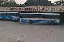
It lies on the National Highway 65 and is equidistant from the Hyderabad and Vijayawada. Suryapet is a major road junction. TSRTC operates buses from Suryapet to several places.
References
- 1 2 3 "Basic Information". Official website of Suryapet. Retrieved 21 February 2016.
- ↑ "Suryapet district" (PDF). New Districts Formation Portal. Retrieved 11 October 2016.
- ↑ "District Census Handbook – Nalgonda" (PDF). Census of India. p. 13. Retrieved 15 February 2016.
- 1 2 3 "Suryapet Municipality Introduction". Commissioner & Director of Municipal Administration. Municipal Administration & Urban Development Department, Government of Telangana. Retrieved 15 February 2016.
- ↑ "Maps, Weather, and Airports for Suryapet, India". fallingrain.com.
- ↑ "Census of India 2001: Data from the 2001 Census, including cities, villages and towns (Provisional)". Census Commission of India. Archived from the original on 2004-06-16. Retrieved 2008-11-01.
- ↑ "Suryapet Metropolitan Region Population". Census 2011, Government of India.
- ↑ "Commissioner Contact". Official website of Kodad municipality. Retrieved 21 February 2016.
- ↑ "Commissioner Contact". Official website of Suryapet municipality. Retrieved 21 February 2016.
- ↑ Keya Acharya. "Trash driving". The Hindu.
- ↑ "Green Leaf Awards presented". The Hindu.
External links
| Wikimedia Commons has media related to Suryapet. |