Surrey Heath (UK Parliament constituency)
| Surrey Heath | |
|---|---|
|
County constituency for the House of Commons | |
|
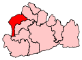
Boundary of Surrey Heath in Surrey. | |
|
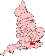
Location of Surrey within England. | |
| County | Surrey |
| Electorate | 78,453 (December 2010) |
| Current constituency | |
| Created | 1997 |
| Member of parliament | Michael Gove (Conservative Party) |
| Created from | North West Surrey, Guildford and Woking |
| Overlaps | |
| European Parliament constituency | South East England |
Surrey Heath is a constituency[n 1] represented in the House of Commons of the UK Parliament since 2005 by Michael Gove, a Conservative.[n 2]
Boundaries
Surrey Heath occupies the northwest corner of the county. It has electoral wards:
- Bagshot, Bisley, Chobham, Frimley, Frimley Green, Heatherside, Lightwater, Mytchett and Deepcut, Old Dean, Parkside, St Michaels, St Pauls, Town, Watchett, West End, and Windlesham in the Surrey Heath District
- Ash South and Tongham, Ash Vale, and Ash Wharf in the Borough of Guildford.
The largest town[n 3] is Camberley. The Boundary Commission made no boundary changes for Surrey Heath in the Fifth Periodic Review of Westminster constituencies before the 2010 general election.
The large village of Ash with Ash Vale and smaller one of Tongham are contiguous, similar to Frimley and Frimley Green.
History
The constituency was created in 1997 from the most part of the seat of North West Surrey (which was abolished) and smaller parts of Woking and Guildford, seats which remain.
On the seat's creation, Nick Hawkins was elected to Parliament following the retirement of Surrey North West MP Michael Grylls who in 1992 achieved a majority of 28,392.[1] One of Hawkins' opponents for selection was future Speaker, John Bercow. Bercow was selected as the Conservative candidate for the Buckingham constituency on the same day.[2]
In 2004, the Conservative constituency association, then the richest in the country, deselected their MP Nick Hawkins in the hope of obtaining an MP of Cabinet calibre.[3]
The Member since 2005, Michael Gove, was formerly Secretary of State for Justice and Lord Chancellor.[4]
Constituency profile
In terms of housing 70% of homes are detached or semi-detached at the 2011 census. The detached percentage (45.2%) was at that time the second highest in the South East, behind the New Forest.[5] The area is well connected to London Heathrow Airport, IT, telecommunications and logistics centres of the M3 and M4 'corridors' and to the military towns of Aldershot and Sandhurst. Farnborough with its civil, private aviation base with certain military uses is also nearby, as is Blackbushe Airport.
Workless claimants, registered jobseekers, were in November 2012 significantly lower than the national average of 3.8%, at 1.7% of the population based on a statistical compilation by The Guardian.[6]
The constituency is one of the Conservative party's safest seats, with most wards firmly in their camp, the exception being the Old Dean ward which usually votes Labour at local level. According to the British Election Study, it is the most right-wing seat in the UK.[7]
Members of Parliament
| Election | Member[8] | Party | |
|---|---|---|---|
| 1997 | Nick Hawkins | Conservative | |
| 2005 | Michael Gove | Conservative | |
Elections
Elections in the 2010s
| Party | Candidate | Votes | % | ± | |
|---|---|---|---|---|---|
| Conservative | Michael Gove | 32,582 | 59.9 | +2.2 | |
| UKIP | Paul Chapman[10] | 7,778 | 14.3 | +8.0 | |
| Labour | Laween Atroshi | 6,100 | 11.2 | +1.0 | |
| Liberal Democrat | Ann-Marie Barker | 4,937 | 9.1 | −16.8 | |
| Green | Kimberley Lawson[11] | 2,400 | 4.4 | N/A | |
| Christian | Juliana Brimicombe | 361 | 0.7 | N/A | |
| Independent | Bob and Roberta Smith[12] | 273 | 0.5 | N/A | |
| Majority | 24,804 | 45.6 | +13.8 | ||
| Turnout | 54,431 | 68.5 | −1.5 | ||
| Conservative hold | Swing | ||||
| Party | Candidate | Votes | % | ± | |
|---|---|---|---|---|---|
| Conservative | Michael Gove | 31,326 | 57.6 | +6.1 | |
| Liberal Democrat | Alan Hilliar | 14,037 | 25.8 | −3.0 | |
| Labour | Matt Willey | 5,552 | 10.2 | −6.5 | |
| UKIP | Mark Stroud | 3,432 | 6.3 | +3.3 | |
| Majority | 17,289 | 31.8 | +9.1 | ||
| Turnout | 54,347 | 70.0 | +7.1 | ||
| Conservative hold | Swing | +4.5 | |||
Elections in the 2000s
| Party | Candidate | Votes | % | ± | |
|---|---|---|---|---|---|
| Conservative | Michael Gove | 24,642 | 51.5 | +1.8 | |
| Liberal Democrat | Rosalyn Harper | 13,797 | 28.8 | +3.1 | |
| Labour | Chris Lowe | 7,989 | 16.7 | −4.7 | |
| UKIP | Steve Smith | 1,430 | 3.0 | −0.3 | |
| Majority | 10,845 | 22.7 | |||
| Turnout | 47,858 | 62.9 | +3.4 | ||
| Conservative hold | Swing | −0.7 | |||
| Party | Candidate | Votes | % | ± | |
|---|---|---|---|---|---|
| Conservative | Nick Hawkins | 22,401 | 49.7 | −1.9 | |
| Liberal Democrat | Mark Lelliott | 11,582 | 25.7 | +3.9 | |
| Labour | James Norman | 9,640 | 21.4 | +0.3 | |
| UKIP | Nigel Hunt | 1,479 | 3.3 | +2.1 | |
| Majority | 10,819 | 24.0 | |||
| Turnout | 45,102 | 59.5 | −14.7 | ||
| Conservative hold | Swing | ||||
Elections in the 1990s
| Party | Candidate | Votes | % | ± | |
|---|---|---|---|---|---|
| Conservative | Nick Hawkins | 28,231 | 51.6 | N/A | |
| Liberal Democrat | David Ian Newman | 11,944 | 21.8 | N/A | |
| Labour | Susan Jones | 11,511 | 21.0 | N/A | |
| Referendum | John Ewart Gale | 2,385 | 4.4 | N/A | |
| UKIP | Richard Peter Farr Squire | 653 | 1.2 | N/A | |
| Majority | 16,287 | 29.8 | N/A | ||
| Turnout | 54,724 | 74.1 | N/A | ||
| Conservative win (new seat) | |||||
See also
Notes and references
- Notes
- ↑ A county constituency (for the purposes of election expenses and type of returning officer)
- ↑ As with all constituencies, the constituency elects one Member of Parliament (MP) by the first past the post system of election at least every five years.
- ↑ occupying the seven wards without individual settlement articles
- References
- ↑ http://www.parliament.uk/documents/commons-information-office/m13.pdf
- ↑ BBC News: The John Bercow story
- ↑ Melissa Kite (27 Jun 2004). "Surrey Heath members believe that their money ought to be able to buy a future prime minister". Daily Telegraph. Retrieved 13 August 2012.
- ↑ "Michael Gove moves to justice in post-election reshuffle". BBC news:Politics. 10 May 2015. Retrieved 10 May 2015.
- ↑ 2011 census interactive maps
- ↑ Unemployment claimants by constituency The Guardian
- ↑ http://www.bbc.co.uk/news/uk-politics-30129990
- ↑ Leigh Rayment's Historical List of MPs – Constituencies beginning with "S" (part 6)
- ↑ "Election Data 2015". Electoral Calculus. Archived from the original on 17 October 2015. Retrieved 17 October 2015.
- ↑ http://surreyheathukip.org.uk/elections
- ↑ "Kimberley Lawson PPC page". Green Party of England and Wales. Retrieved 1 March 2015.
- ↑ Clark, Nick (3 December 2014). "Bob and Roberta Smith will run against Michael Gove at the election on culture platform". Independent. Retrieved 1 March 2015.
- ↑ "Election Data 2010". Electoral Calculus. Archived from the original on 17 October 2015. Retrieved 17 October 2015.
- ↑ "Election Data 2005". Electoral Calculus. Archived from the original on 15 October 2011. Retrieved 18 October 2015.
- ↑ "Election Data 2001". Electoral Calculus. Archived from the original on 15 October 2011. Retrieved 18 October 2015.
- ↑ "Election Data 1997". Electoral Calculus. Archived from the original on 15 October 2011. Retrieved 18 October 2015.
Sources
- Election result, 2010 (BBC)
- Election result, 2005 (BBC)
- Election results, 1997 - 2001 (BBC)
- Election results, 1997 - 2001 (Election Demon)
- Election results, 1997 - 2010 (Guardian)
Coordinates: 51°21′N 0°42′W / 51.35°N 0.70°W