Surobi District (Kabul)
| Surobi District | |
|---|---|
| District | |
 | |
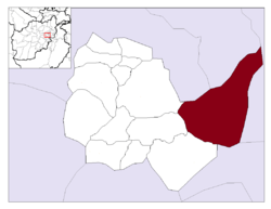 Location in Kabul Province | |
| Country |
|
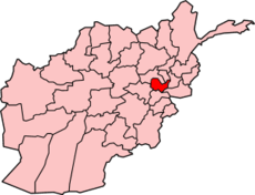
| Province | Kabul Province |
| Capital | Surobi |
| Population (2015) | |
| • Total | 56,642 |
| Time zone | AST (UTC+04:30) |
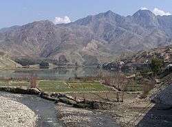
Surobi, Sarobi, or Sarubi District is a district of Kabul Province, Afghanistan. Its capital, Surobi, lies about 60 kilometres east of Kabul along the A01 highway, although much of the district lies northeast of Kabul. Surobi is famous all over Afghanistan as it is birthplace to Faisal Babakarkhail a well known Jihadi commander famous for his bravery and courage against Soviet Troops.[1] Its principal river is the Kabul River.
History
In the 1990s, the Khalid Bin Whalid training camp was situated in the district.[2] In 1998, the camp was leveled by U.S. cruise missiles in retaliation for the 1998 United States embassy bombings.[3]
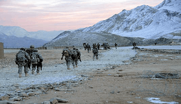
On July 23, 2007, an improvised explosive device detonated near a US vehicle in the district, killing four soldiers: 1st Sgt. Michael S. Curry Jr., Sgt. Travon T. Johnson, Pfc. Adam J. Davis and Pfc. Jessy S. Rogers.[4]
"One of the last reports of Uzbek IMU (Islamic Movement of Uzbekistan) fighters active inside Afghanistan" came from Surobi District in October 2007.[5]
Surobi was the site of a major action by the French Foreign Legion in December 2009.[6]
Demographics
The Afghan Ministry of Rural Rehabilitation and Development (MRRD) along with UNHCR and Central Statistics Office (CSO) of Afghanistan estimates the population of the district to be around 44,871.[7] According to AIMS and UNHCR, Pashtuns make up over 90% of the total population, while ethnic Pashais make up the remaining 10% of the population.[8]
Geography
Surobi District borders Bagrami and Deh Sabz districts to the west, Parvan and Kapisa provinces to the north, Laghman Province to the east, and Nangarhar Province and Khaki Jabbar District to the south.
There are 130 villages in Surobi District. The Kabul River travels through the centre of the district and keeps the two sides of the district quite green. Three dams are in the district — Naghlu Dam, Mahipar Dam and Barqi-Surobi Dam — which generate electricity for Kabul and the district itself. However, due to lack of water, Mahipar Dam is out of order for now. Each village has its own governor or leader.
References
- ↑ Coleman, Lyman (2010). Called to Serve: An Historical Novel. Trafford Publishing. p. 122. ISBN 978-1-4269-3036-2. Retrieved 18 April 2011.
- ↑ Hussain, Zahid (2 July 2008). Frontline Pakistan: The Struggle With Militant Islam. Columbia University Press. p. 96. ISBN 978-0-231-14225-0. Retrieved 18 April 2011.
- ↑ Laura Miller (2002-07-17). "My Jihad". Salon magazine. Retrieved 2012-11-25.
- ↑ IntelCenter; Tempest Publishing (24 April 2008). IntelCenter Terrorism Incident Reference (TIR): Afghanistan, 2000-2007. Tempest Publishing. p. 516. ISBN 978-0-9665437-8-0. Retrieved 18 April 2011.
- ↑ Giustozzi, Antonio (15 October 2009). Decoding the new Taliban: insights from the Afghan field. Columbia University Press. p. 77. ISBN 978-0-231-70112-9. Retrieved 18 April 2011.
- ↑ "French troops spearhead assault in Afghanistan". BBC News. 17 December 2009. Retrieved 18 April 2011.
- ↑ "Kabul PDP Provincial profile" (PDF). Archived from the original (PDF) on 2010-12-02. Retrieved 2012-11-25.
- ↑ "UNHCR profile for Surobi District" (PDF). Retrieved 2012-11-25.
External links
| Wikimedia Commons has media related to Surobi District (Kabul). |
Coordinates: 34°38′N 69°44′E / 34.63°N 69.73°E