Superior Hiking Trail
| Superior Hiking Trail | |
|---|---|
|
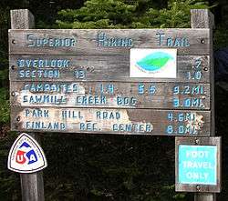
A sign at a Superior Hiking Trail trailhead near Finland, Minnesota | |
| Length | 310 mi (499 km) |
| Location | Cook / Lake / Saint Louis / Carlton counties, Minnesota, United States |
| Trailheads |
Near Jay Cooke State Park; Canada–US border near Lake Superior |
| Use | Hiking |
| Elevation | |
| Highest point | 1,829 ft (557 m) |
| Lowest point | Lake Superior, 602 ft (183 m) |
| Hiking details | |
| Trail difficulty | Moderate |
| Season | Late spring to early fall |
| Sights | Lake Superior, Iron Range, state parks |
| Hazards | Severe weather, black bears, Lyme disease |
The Superior Hiking Trail, also known as the SHT, is a 310-mile (499 km) long footpath in northeastern Minnesota that follows the ridgeline overlooking Lake Superior for most of its length. The path is 18 inches (46 cm) wide and is set in the middle of a 4-foot (1.2 m) clearing. The footpath travels through forests of birch, aspen, pine, fir, and cedar. Hikers enjoy views of boreal forests, the Sawtooth Mountains, babbling brooks, rushing waterfalls, and abundant wildlife. The lowest point in the path is 602 feet (183 m) above sea level and the highest point is 1,829 feet (558 m) above sea level. The footpath is intended for hiking only. Motorized vehicles, mountain bikes, and horses are not allowed on the trail. Many people use the footpath for long-distance hiking. Facilitating this purpose are 93 backcountry, fee-free campsites.[1][2]
History
Construction of the Superior Hiking Trail began in the mid-1980s, and the trail now extends 313 miles (504 km) from Duluth to the Canada–US border, 17 miles (27 km) of which are spur trails to the main trail. Inspiration for building the trail came from the Appalachian Trail, which extends from Georgia to Maine. The Superior Hiking Trail Association (SHTA) was formed in 1986 to manage the construction, planning, and day-to-day care of the trail. The SHTA received several grants from the State of Minnesota, three of which were from the Legislative Commission on Minnesota Resources. This money helped jump start the construction of the trail and funded construction for the first few years. In 1987, the trail had an opening ceremony at Britton Peak to celebrate the beginning of construction. The ceremony included a log-cutting event and many state government officials and SHTA founders attended. Three years later, in August 1990, the trail had reached a half-way mark and another celebration was held. That celebration included a 140-mile (225 km) hike for about a dozen brave hikers who completed it in 12 days.[3] Since 1991, a 100-mile (161 km) ultramarathon known as the "Superior 100", along with several other races, has been hosted annually on the Superior Hiking Trail.[4] In 1995, Paul Hlina, who was paralyzed from the waist down, hiked the entire trail on crutches and is now known as the first hiker to thru-hike the trail. He raised $16,000 in pledges for the Superior Hiking Trail Association, the non-profit organization which maintains the trail.[5] Trail construction and improvements continued, and in 2013 the Superior Hiking Trail became a continuous footpath from Jay Cooke State Park to the 270 Degree Overlook near the Canada–US border.[3]
Sections of the trail

There are two primary sections to the Superior Hiking Trail.
The Duluth section of the trail comprises 41 miles (66 km) and starts southwest of the city of Duluth at a trailhead in Jay Cooke State Park. The trail extends to the northeast through the Spirit Mountain Recreation Area, Brewer Park, Enger Park, the Historic Downtown Area, Canal Park, the Lakewalk, and Hartley Nature Center,[6] before it ends at a trailhead located on Martin Road on the north side of the city. The Duluth section provides opportunities for day hiking.[1]
The North Shore section of the trail is 255 continuous miles (410 km) and begins at the Martin Road Trailhead on the northern boundary of the City of Duluth. From there, the trail extends to the northeast along Lake Superior through seven state parks, including Gooseberry Falls State Park, Split Rock Lighthouse State Park and Tettegouche State Park. This section of the SHT passes near the towns of Lutsen and Grand Marais, and ends just before the Canada–United States border. The North Shore section provides backcountry experiences and is utilized by both day hikers and backpackers. A thru-hike of the Superior Hiking Trail typically spans this 255-mile section. The total elevation gain along the North Shore section is 37,800 feet (11,500 m) and the elevation loss is 37,400 feet (11,400 m) for a northbound hiker.[1][2]
On the northern end the Superior Hiking Trail is connected to the 65-mile (105 km) long Border Route Trail which starts a short distance from the trail head on Otter Lake Road.[7] This then connects to the 41-mile (66 km) long Kekekabic Trail which gives the hiker the ability to hike all the way through the Boundary Waters Canoe Area Wilderness and end near Ely. There are also plans to extend the southern terminus of the Superior Hiking Trail to connect it with the North Country National Scenic Trail.[3][8]
The Superior Hiking Trail Association


The Superior Hiking Trail Association (SHTA) builds, promotes and maintains the trail. It is a Minnesota-based non-profit corporation with more than 3200 members. The association produces a quarterly newsletter called The Ridgeline for its members which contains noteworthy news of the trail, trail volunteer bios, and association financial information. The most visible activities of the SHTA are the popular organized hikes featuring leaders with interpretive skills, such as naturalists, geologists, photographers, and historians and ranging from day hikes to backpacking trips of several days' duration.
The trail was mostly built by crews of people that were hired from local towns or by the Minnesota Conservation Corps. In addition, the SHTA coordinates the efforts of numerous volunteers who assist with trail and campground construction and maintenance. These volunteers include interested individuals, scout troops, and other outdoor organizations. Some groups have chosen to adopt a section of the trail to maintain, while others participate in scheduled maintenance hikes.[1][2]
Accolades
In December, 2000, Backpacker Magazine named the Superior Hiking Trail the trail with the "Best Trail/Camp/Shelter conditions," the trail with the "Best Signage" in the country, and one of the most scenic trails in the nation.[9]
According to Andrew Skurka of National Geographic, Superior Hiking Trail is one of his ten favorite hikes in America [10]
In the May, 2005, Readers Digest listed Superior Hiking Trail as one of the "5 Best Hikes in America".[11]
See also
References
- 1 2 3 4 Superior Hiking Trail Association: Guide to the Superior Hiking Trail, Seventh Edition, Superior Hiking Trail Association, 2013.
- 1 2 3 http://www.shta.org/
- 1 2 3 Superior Hiking Trail Association: Guide to the Superior Hiking Trail, Seventh Edition, Pages 10-11, Superior Hiking Trail Association, 2013.
- ↑ http://www.superiortrailrace.com/
- ↑ Superior Hiking Trail Association: Guide to the Superior Hiking Trail, Fifth Edition, Page 11, Ridgeline Press, 2007.
- ↑ http://www.hartleynature.org/index.html
- ↑ http://www.shta.org/Trail/TrailMaps/s085.php
- ↑ http://www.northcountrytrail.org/explore/ex_mn/mn.htm
- ↑ https://books.google.com/books?id=9uIDAAAAMBAJ&lpg=PP1&lr&rview=1&pg=PA41#v=onepage&q&f=false
- ↑ http://www.nationalgeographic.com/adventure/hiking/best-trails-andrew-skurka-short.html#superior
- ↑ http://www.rd.com/advice-and-know-how/5-best-hikes-in-america/article15045.html
External links
| Wikimedia Commons has media related to Superior Hiking Trail. |
- Superior Hiking Trail Association
- Superior Hiking Trail from Minnesota Department of Tourism
- A Superior Hiking Trail Thru Hiker's Trail Journal and Itinerary
- Walking Guide To The Superior Hiking Trail, Trail Maps, and Trail GPS Paths
- Journals and Photos from The Superior Hiking Trail
Coordinates: 47°34′25″N 90°50′10″W / 47.57361°N 90.83611°W