Sunnymead

Coordinates: 51°47′06″N 1°15′58″W / 51.785°N 1.266°W
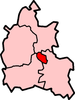
Sunnymead is a suburb in the northern part of Oxford, England, just south of the Oxford Ring Road (A40). Close by are the suburbs of Cutteslowe to the north, Summertown to the south and Upper Wolvercote to the west. To the east is the River Cherwell, which flows south towards central Oxford.
See also
The City of Oxford | ||
|---|---|---|
| Wards, suburbs, neighbourhoods and districts |
|  |
| Civil parishes | ||
| Former district and borough | ||
| Former constituencies | ||
This article is issued from Wikipedia - version of the 1/13/2013. The text is available under the Creative Commons Attribution/Share Alike but additional terms may apply for the media files.