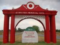
Sundergarh
| Sundergarh ସୁନ୍ଦରଗଡ଼ Sundargarh | |
|---|---|
| City | |
 Sundergarh  Sundergarh Location in Odisha, India | |
| Coordinates: 22°07′N 84°02′E / 22.12°N 84.03°ECoordinates: 22°07′N 84°02′E / 22.12°N 84.03°E | |
| Country | India |
| State | Odisha |
| District | Sundargarh |
| Elevation | 233 m (764 ft) |
| Population (2011) | |
| • Total | 45,036 |
| Languages | |
| • Official | Oriya |
| Time zone | IST (UTC+5:30) |
| Telephone code | 06622 |
| Vehicle registration | OD-16 |
| Website | http://sundergarh.nic.in/ |
Sundergarh is a town in Sundergarh district of the Indian state of Odisha. As of 2011 census, the municipality had a population of 45,036.[1][2]Sundargarh is recognized as an industrial district in the map of Odisha. Steel Plant, Fertilizer Plant, Cement factory, Ferro Vanadium Plant, Machine building factory, Glass and china clay factory and Spinning mills are some of the major industries of this District. Sundargarh occupies a prominent position in the mineral map of Odisha and is rich in iron ore, limestone, manganese, dolomite, and fire clay. Major industries are the Odisha Cements ltd, Hart Fertilizers Ltd, and Odisha Industries Ltd. The industrial town of Rourkela in this District has the first government sector plant built with foreign collaboration and was the first in India to use LD oxygen technology.
Geography
. Geographically, the district is not a compact unit and consists of widely dissimilar tracts of expansive and fairly open, dotted with tree, clad isolated peaks, vast inaccessible forests, extensive river valleys and mountainous terrain. Broadly speaking, it is an undulating tableland of different elevations broken up by rugged hill ranges and cut up by torrential hill streams and the rivers IB and Brahmani. The general slope of the District is from north to south. Because of this undulating, hilly and sloping nature of landscape, the area is subjected to rapid runoff leading not only to soil erosion but also to scarcity of water for both agriculture and drinking purposes. Brahmani, Sankh, Koel and IB are the major rivers flowing though this District. Covering a geographical area of 9,712 sq km, Sundargarh District is the second largest District of the state, accounting for 6.23 percent of its total area. Out of this total area, forests cover 4,232.57 sq km, this being the second largest in the state, accounting for 8.53 percent of the state total. Sundargarh is located at 22°07′N 84°02′E / 22.12°N 84.03°E.[3] It has an average elevation of 243 metres (801 feet). It is divided into three subdivisions named Sundargarh,Panposh and Bonaigarh. Sundargarh District has 3 sub divisions, 16 Tehsils, 17 Blocks and 262 Gram panchayats.
Climate
The climate of this District is characterized by extremely hot summers and cool winters. Climate is hot & moist sub humid. Normal rainfall of the District is approximately 1230 mm, but there is a deviation in receipt of rainfall pattern which is influencing crop production.
History
Sundargarh was the capital of the princely State of Gangpur till 1948 and became the district headquarters of Sundargarh district from 1948. It is understood that, in ancient times, Sundargarh was under the rulers of different dynasties. However, divergent views are available regarding the origin of the ruling family. The present royal family of Gangpur belongs to the Parmar dynasty. This ex-state was under the suzerainty of Sambalpur,known as Hirakhand Desh and later formed part of the dominion of the Maratha Rajas of Nagpur. This was ceded to the British Government in 1803 by the Maratha Chief Raghuji Bhonsla of Nagpur under the treaty of Deogaon(near Rourkela). But this was restored to him by special engagement in 1806. This was finally ceded in 1826. In 1905, this princely state along with Bonai was transferred from the control of the commissioner of Chhotanagur to that of Ofidha Division and a separate Political Agent was appointed.
Demographics
As of 2001 India census,[4] The population of this District is 2,080,664, this being the fifth most populous District of the state. Its rural population exceeds twelve lakhs and the urban population is more than six lakhs. The male literacy rate is 82.13 and female literacy rate in the District is 65.93. Tribal people constitute 50.69% of the population and 65.22% of the entire population lives below the poverty line. Health and sanitation facilities are not adequately developed in this area. There are 45 primary health centres for the entire district and the infant mortality rate is 62 per 1000 live births. As per 2001 census, total literacy rate is 65.22% with the male literacy rate at 75.69% and female literacy rate at 54.25%. The 1991 census found that the tribal literacy rate stood at 37.34%. People are dependent on forest and agriculture for their livelihood. The total area of cultivable land is 3,36,000 hectares with 1.55 hectares as the average size of operational land holding. The district consists of vast inaccessible forests, river valleys and mountainous terrain. Due to the undulating hilly and sloping landscape, the area is often subject to floods and drought.
Politics
Current MLA from Sundargarh Assembly Constituency is Jogesh Singh of [INC], who won the seat in by-elections in 2006 after Sushama Patel who won the seat by election due to death of her husband and seating MLA Sankarsan Naik who won the seat in 2004 General Election. Previous MLAs from this seat were Kishore Chandra Patel who won this seat representing INC in 1995 and in 1977, and also representing INC(I) in 1980, and Bharatendra Shekhar Deo who won this seat representing JD in 1990 and representing JNP in 1985.[5] Sundargarh is part of Sundargarh (Lok Sabha constituency).[6]
Sports
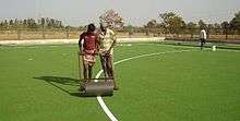
A new synthetic (polygrass) hockey turf has been laid at the SAI Sports Complex in Bhawanipur, Sundargarh. This is the third synthetic hockey turf in the district of Sundargarh. The other turfs are at Panposh (Panposh Hockey Hostel) and Rourkela (Biju Patnaik Hockey Stadium). The Sports Authority of India (SAI) had approved the Rs. 2.25 crores project in 2007. The base work for the turf began in 2007, and was completed by May 2008. Then began the wait for synthetic turf, which arrived only in November 2008, and subsequently laid by February 2009.
See also
- Dilip Tirkey - Hockey star from Sundergarh
References
- ↑ "Census 2011". The Registrar General & Census Commissioner, India. Retrieved 1 August 2014.
- ↑ "Municipality". National Informatics Centre. Retrieved 26 April 2015.
- ↑ Falling Rain Genomics, Inc -Sundargarh
- ↑ "Census of India 2001: Data from the 2001 Census, including cities, villages and towns (Provisional)". Census Commission of India. Archived from the original on 2004-06-16. Retrieved 2008-11-01.
- ↑ "State Elections 2004 - Partywise Comparison for 135-Sundargarh Constituency of Odisha". Election Commission of India. Retrieved 2008-09-18.
- ↑ "Assembly Constituencies - Corresponding Districts and Parliamentary Constituencies of Odisha" (PDF). Election Commission of India. Retrieved 2008-09-18.