Sun Valley, Los Angeles
| Sun Valley | |
|---|---|
| Neighborhood of Los Angeles | |
|
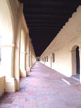
Stonehurst Recreation Center building | |
 Sun Valley. as delineated by the Los Angeles Times | |
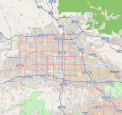 Sun Valley Location within Los Angeles and the San Fernando Valley | |
| Coordinates: 34°13′03″N 118°22′10″W / 34.2175°N 118.36944°W |

Sun Valley is a neighborhood in the San Fernando Valley region of the city of Los Angeles, California. The neighborhood is known for its overall youthful population and moderate racial diversity. There are three recreation centers in Sun Valley, one of which is a historic site. The neighborhood has thirteen public schools — including John H. Francis Polytechnic High School and Sun Valley High School — and four private schools.
Population
The 2000 U.S. census counted 75,848 residents in the 9.42-square-mile Sun Valley neighborhood—or 8,048 people per square mile, about an average population density for the city. In 2008, the city estimated that the population had increased to 81,788. In 2000 the median age for residents was 28, considered young for city and county neighborhoods; the percentage of residents aged 10 or younger was among the county's highest.[1]
The neighborhood was considered "moderately diverse" ethnically within Los Angeles, with a high percentage of Latinos. The breakdown was Latinos, 69.4%; whites, 17.9%; Asians, 8.1%; blacks, 1.9%; and others, 2.7%. Mexico (54.5%) and El Salvador (11.9%) were the most common places of birth for the 51.9% of the residents who were born abroad—a high percentage for Los Angeles.[1]
The median yearly household income in 2008 dollars was $51,290, considered average for the city but low for the county. The percentages of households that earned $20,000 to $60,000 were high for the county. Renters occupied 46.1% of the housing stock, and house or apartment-owners held 53.9%.[1]
Geography
Sun Valley is bordered on the northeast by Shadow Hills, on the southeast by Burbank, on the south by North Hollywood and Valley Glen, on the west by Panorama City and on the northwest by Pacoima, Hansen Dam and Lake View Terrace.[2]
Situated at the base of the Verdugo Mountains, Sun Valley is prone to flash floods, and one such flood on Sunday, February 20, 2005 at 2237 (10:37 PM PST) destroyed a portion of the 8000 block of Tujunga Avenue and killed a Los Angeles City civil engineer when a sinkhole 30 feet deep opened.[3]
Nearby places
Relation of Sun Valley to nearby places, not necessarily contiguous:[2]
 |
Pacoima & Arleta | Hansen Dam & Lake View Terrace, | Shadow Hills & Sunland-Tujunga | |
| Panorama City | |
Verdugo Hills | ||
| ||||
| | ||||
| Van Nuys | North Hollywood & Valley Glen | Burbank |
History
.jpg)
In 1874, California State Senator Charles Maclay (for whom Maclay Street in San Fernando is named) acquired 56,000 acres (230 km2) of land across the San Fernando Valley. The area extended from Sunland Blvd. all the way west to the Chatsworth Hills. East of Sunland was Rancho San Rafael, a large land grant to José María Verdugo by the Spanish Crown.
By 1876, the Southern Pacific Railroad was constructed through the eastern San Fernando Valley, linking Southern and Northern California. The area once had a general store named Roberts. The change to the current name of Sun Valley was made in 1948 by residents.[4]
Foundation
- The Theodore Payne Foundation for Wild Flowers and Native Plants is located in Sun Valley; it is dedicated to helping people discover the beauty of California native plants.
Economy
The Consulate-General of the Dominican Republic in the County of Los Angeles is located in Suite 204 at 9001 Laurel Canyon Boulevard.[5]
Government and infrastructure

Los Angeles Fire Department Fire Station 77[6] is located in the Sun Valley area. The station is in the Battalion 12 district.
The United States Postal Service Sun Valley Post Office is located at 10946 Ratner Street.[7]
Education
One of every ten of Sun Valley residents aged 25 and older had earned a four-year degree by 2000, a low percentage for both the city and the county. The percentage of the same-age residents with less than a high school diploma was high for the county.[1][8]
Schools within the Sun Valley boundaries are:[9]
Public
- John H. Francis Polytechnic High School, 12431 Roscoe Boulevard
- Sun Valley High School, 9171 Telfair Avenue
- Fernangeles Elementary School, 12001 Art Street
- Robert H. Lewis Continuation school, 12508 Wicks Street
- Richard E. Byrd Middle School, 8501 Arleta Avenue
- Arminta Street Elementary School, 11530 Strathern Street
- Strathern Street Elementary School, 7939 St. Clair Avenue
- Saticoy Elementary School, 7850 Ethel Avenue
- Glenwood Elementary School, 8001 Ledge Avenue
- Roscoe Elementary School, 10765 Strathern Street
- Charles Leroy Lowman Special Education Center, 12827 Saticoy Street
- Camelia Avenue Elementary School, 7451 Camelia Avenue
- Sun Valley Magnet School, 7330 Bakman Avenue
- East Valley Skill Center (Adult School), 8601 Arleta Avenue [10]
- Fenton Leadership Academy, 8926 Sunland Boulevard, Sun Valley, California 91352 (K-2)
- Fenton STEM Academy, 8926 Sunland Boulevard, Sun Valley, California 91352 (3-5)
Private
- St. Augustine Academy, 9000 Sunland Boulevard
- Grace Community, 13248 Roscoe Boulevard
- Messiah Lutheran School, elementary, 12020 Cantara Street
- Our Lady of the Holy Rosary, elementary, 7802 Vineland Avenue
- Village Christian School
Public libraries
The Los Angeles Public Library operates the Sun Valley Branch.[11]
Parks and recreation
- The Sun Valley Recreation Center in Sun Valley includes a public swimming pool,[12] lighted baseball diamond, lighted outdoor basketball courts, a children's play area, a football field, picnic tables, a lighted soccer field, lighted tennis courts, and lighted volleyball courts.[13]
- The Fernangeles Recreation Center in Sun Valley includes a public swimming pool,[14] an auditorium, barbecue pits, a lighted baseball diamond, lighted indoor basketball courts, lighted outdoor basketball courts, a children's play area, a lighted football field, an indoor gymnasium with weights, picnic tables, and a lighted soccer field.[15]
- The Stonehurst Recreation Center in Sun Valley is a historic site. The center has an indoor gymnasium and auditorium with a capacity of 400 people, barbecue pits, a lighted baseball diamond, lighted outdoor basketball courts, a children's play area, a community room, a lighted football field, an indoor gymnasium with weights, picnic tables, a lighted soccer field, and volleyball courts.[16]
References
- 1 2 3 4 "Sun Valley," Mapping L.A., Los Angeles Times
- 1 2 Map, Mapping L.A., Los Angeles Times; accessed November 12, 2016.
- ↑ LAFD Blogspot, "City Civil Engineer Fatality in North Hollywood", lafd.blogspot.com; accessed November 12, 2016.
- ↑ Ira Gribin, "Sun Valley Once Known as Roberts Store, Roscoe", May 10, 1981, page VB1.
- ↑ "Dominican Consulates in the United States of America". Embassy of the Dominican Republic in the United States. Retrieved on January 31, 2009.
- ↑ "Los Angeles Fire Department — Fire Station 77".
- ↑ "Post Office Location - SUN VALLEY". United States Postal Service. Retrieved on December 6, 2008.
- ↑ "Less Than High School," Mapping L.A., Los Angeles Times
- ↑ Sun Valley: Schools. Mapping L.A., Los Angeles Times
- ↑ North Valley Service Area- East Valley Skill Center
- ↑ "Sun Valley Branch Library". Los Angeles Public Library.
- ↑ LA Parks - Sun Valley Swimming Pool & Slide http://laparks.org/dos/aquatic/facility/sunValleyPool.htm
- ↑ "Sun Valley Recreation Center." City of Los Angeles. Retrieved on March 19, 2010.
- ↑ LA Parks - Fernangeles Pool
- ↑ "Fernangeles Recreation Center". City of Los Angeles. Retrieved on March 19, 2010.
- ↑ "Stonehurst Recreation Center". City of Los Angeles. Retrieved on March 19, 2010.
External links
| Wikimedia Commons has media related to Sun Valley, Los Angeles. |
- Sun Valley Area Neighborhood Council
- The Theodore Payne Foundation for Wild Flowers and Native Plants — in Sun Valley
- Sun Valley Hills — a community website for CERT, emergency and other information
- Sun Valley crime map and statistics
| Districts and neighborhoods |
|  |
|---|---|---|
| Points of interest | ||
| Neighboring cities and communities | ||
| Topics |  | |
|---|---|---|
| Government | ||
Coordinates: 34°13′03″N 118°22′10″W / 34.2175°N 118.36944°W