Sun River
| Sun River | |
| Medicine River, Pointed Rock River | |
| River | |
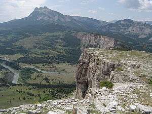 The headwaters of the Sun River in the Rockies, near Gibson Reservoir | |
| Country | United States |
|---|---|
| State | Montana |
| Part of | Missouri River watershed |
| Tributaries | |
| - left | North Fork Sun River, Muddy Creek |
| - right | South Fork Sun River, Willow Creek |
| Cities | Fairfield, Sun River, Vaughn, Great Falls |
| Primary source | North Fork Sun River |
| - location | Confluence of Open Creek and McDonald Creek, Lewis and Clark County |
| - elevation | 5,781 ft (1,762 m) [1] |
| - coordinates | 47°54′43″N 112°58′23″W / 47.91194°N 112.97306°W [2] |
| Secondary source | South Fork Sun River |
| - location | Sun Lake, Lewis and Clark County |
| - elevation | 6,988 ft (2,130 m) [3] |
| - coordinates | 47°20′07″N 112°53′29″W / 47.33528°N 112.89139°W [4] |
| Source confluence | |
| - location | Near Gibson Reservoir, Lewis and Clark County |
| - elevation | 4,728 ft (1,441 m) [2] |
| - coordinates | 47°37′47″N 112°51′25″W / 47.62972°N 112.85694°W [5] |
| Mouth | Missouri River |
| - location | Great Falls, Cascade County |
| - elevation | 3,314 ft (1,010 m) [5] |
| - coordinates | 47°29′42″N 111°18′43″W / 47.49500°N 111.31194°WCoordinates: 47°29′42″N 111°18′43″W / 47.49500°N 111.31194°W [5] |
| Length | 130 mi (209 km) |
| Basin | 1,875 sq mi (4,856 km2) [6] |
| Discharge | for Vaughn |
| - average | 669 cu ft/s (19 m3/s) [7] |
| - max | 53,500 cu ft/s (1,515 m3/s) |
| - min | 20 cu ft/s (1 m3/s) |
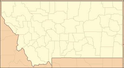 Location of the mouth of the Sun River in Montana | |
The Sun River (also called the Medicine River) is a tributary of the Missouri River in the Great Plains, approximately 130 mi (209 km) long, in Montana in the United States.
It rises in the Rocky Mountains in two forks, the North Fork and South Fork, which join in the Flathead National Forest above Gibson Reservoir along the county line between Teton and Lewis and Clark counties. It flows E, SE, and E away from the mountains, past Simms, Sun River, and Vaughn and joins the Missouri at Great Falls.
The water of the river is used extensively for irrigation, through the Sun River Project of the United States Bureau of Reclamation. The irrigation area covers approximately 92,000 acres (372 km²).
The North Fork of the Sun River begins high up in the Bob Marshall Wilderness and flows generally Southward for about 20 miles (32 km) until it meets up with the South Fork of the Sun River. Almost immediately the two forks flow into Gibson Reservoir, impounded by Gibson Dam. From when the water leaves the reservoir until it meets the Missouri River in Great Falls, the flowage is known as the Sun River.
The Sun is a Class I river from Gibson Dam to its confluence with the Missouri River for public access for recreational purposes.[8]
History
A sign located 3 miles south of Great Falls gives information on the history of the Sun River.
This river was called "The Medicine" by the Indians. On the return trip from the coast Capt. Lewis of the Lewis & Clark Expedition struck this river approximately 50 miles west of here. He followed it down to the Missouri passing near this point July 11, 1806. In his journal under that date he said:"when I arrived in sight of the white-bear Islands the missouri bottoms on both sides of the river were crowded with buffaloe I sincerely beleif (sic) that there were not less than 10 thousand buffaloe within a circle of 2 miles around that place"
The City of Great Falls covers a portion of the plain across which the Expedition made their difficult 18 mile portage around the falls of the Missouri in June 1805
See also

External links
Notes
- ↑ http://geonames.usgs.gov/apex/f?p=gnispq:3:::NO::P3_FID:801259
- 1 2 U.S. Geological Survey Geographic Names Information System: Sun River
- ↑ http://geonames.usgs.gov/apex/f?p=gnispq:3:::NO::P3_FID:801565
- ↑ http://geonames.usgs.gov/apex/f?p=gnispq:3:::NO::P3_FID:801498
- 1 2 3 U.S. Geological Survey Geographic Names Information System: Sun River
- ↑ Derived from USGS statistics for drainage area above Vaughn, MT with about 36 square miles (93 km2) added to represent drainage below this station
- ↑ "USGS Gage #06089000 on the Sun River near Vaughn, Montana: Water-Data Report 2009" (PDF). National Water Information System. U.S. Geological Survey. Retrieved 2010-09-30.
- ↑ Stream Access in Montana
- ↑ Christopherson, Ed (1970). Montana Historic Markers. Missoula, Montana: Earthquake Press. p. 3.