Summit Lake (Paxson, Alaska)
| Summit Lake | |
|---|---|
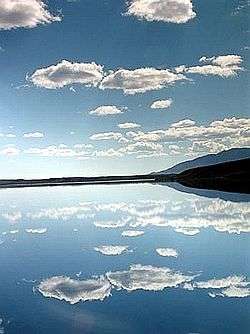 A summer view across Summit Lake | |
 Summit Lake Location of Summit Lake within the State of Alaska | |
| Location |
Paxson, Alaska United States |
| Coordinates | 63°8′20″N 145°33′00″W / 63.13889°N 145.55000°W |
| Type | Natural lake |
| Part of | Copper River Basin |
| Primary inflows | Gunn Greek |
| Primary outflows | Gulkana River |
| Basin countries | United States |
| Max. length | 7.1 miles (11.4 km)[1]:5 & 7 |
| Max. width | 1.1 miles (1.8 km)[1]:5 & 7 |
| Surface area | 6.38 miles (10.27 km)[1]:5 & 7 |
| Average depth | 70 feet (21 m)[1]:5 & 7 |
| Max. depth | 214 feet (65 m)[1]:5 & 7 |
| Water volume | 1,083,344 cubic yards (828,276 m3)[2] |
| Surface elevation | 3,300 feet (1,000 m)[1]:5 |
| Frozen | From early November to mid-June[1]:5 |
| Islands | 1 |
Summit Lake is located above the tree line on the south slope of the Alaska Range[1]:2 & 5 between miles 192 and 196 of the Richardson Highway (AR-4). It is about 200 miles (320 km) north of Valdez, 180 miles (290 km) south of Fairbanks, and just south of Isabel Pass at an elevation of 3,300 feet (1,000 m).[1]:2 & 5 It is also situated within the northeast corner of the census-designated place of Paxson,[3] about 15 miles (24 km) upstream (north) of Paxson Lake.[1]:2
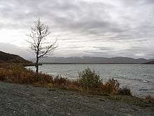
It is glacier-fed by several creeks to the north, including Gunn Creek (which flows from the Gulkana Glacier).[1]:13 There are also additional creeks that feed into the lake from the west and southeast. The lake is up to 300 feet (91 m) deep and is covered with ice up to 5 feet (1.5 m) thick from November until mid-June. It is also the headwaters of the Gulkana River (a main tributary of the Copper River)[1]:2 well known for its "Copper River Reds" salmon, which migrate in late September to spawn in Gunn Creek on the north end of the lake. The lake is 7.1 miles (11.4 km) long, 1.1 miles (1.8 km) wide, and has a surface area of 6.28 square miles (16.3 km2).[1]:5 & 7 [2]
The area is known for the annual Arctic Man Summit Lake Classic ski and snow-machine race, attended by up to 13,000 visitors each April, weather permitting.[4]
See also
- Gulkana River
- Paxson, Alaska
- Richardson Highway
- Summit Lake (Alaska)--disambiguation page
References
- 1 2 3 4 5 6 7 8 9 10 11 12 13 Van Whye, George L; Peck, James W. (1 Jul 1968). A Limnological Survey of Paxson and Summit Lakes (PDF). Alaska Department of Fish and Game. Retrieved 9 Nov 2015.
- 1 2 "Summit Lake (Paxson): Bathymetric Map and Fishing Information". adfg.alaska.gov. Alaska Department of Fish and Game. Retrieved 30 Dec 2015.
- ↑ Google (7 Nov 2015). "Paxson, Alaska" (Map). Google Maps. Google. Retrieved 7 Nov 2015.
- ↑ "About the Race". arcticman.com. Retrieved 9 Nov 2015.
External links
- Summit Lake, AK on Facebook
- Summit Lake (Paxson): Bathymetric Map and Fishing Information (Alaska Department of Fish and Game webpage)
- Arctic Man (official website)