Sumiton, Alabama
| Sumiton | |
|---|---|
| City | |
 Location in Walker County and the state of Alabama | |
| Coordinates: 33°44′50″N 87°2′48″W / 33.74722°N 87.04667°W | |
| Country | United States |
| State | Alabama |
| Counties | Walker, Jefferson |
| Area | |
| • Total | 5.3 sq mi (13.7 km2) |
| • Land | 5.3 sq mi (13.7 km2) |
| • Water | 0 sq mi (0 km2) |
| Elevation | 515 ft (157 m) |
| Population (2013)[1] | |
| • Total | 2,466 |
| • Density | 502.8/sq mi (194.5/km2) |
| Time zone | Central (CST) (UTC-6) |
| • Summer (DST) | CDT (UTC-5) |
| ZIP code | 35148 |
| Area code(s) | 205 |
| FIPS code | 01-73848 |
| GNIS feature ID | 0153607 |
| Website | http://www.thecityofsumiton.com/ |
Sumiton is a city in Jefferson and Walker counties in the State of Alabama. It incorporated in 1952.[2] At the 2010 census the population was 2,520, down from 2,665 in 2000.
A long-track EF3 tornado struck Sumiton on April 24, 2010. The rotation started in Parrish. It later crossed into Cordova on Highway 78 and expired after reaching Interstate 65 near Highway 160, southwest of Hayden.
Geography
Sumiton is located at 33°44′50″N 87°2′48″W / 33.74722°N 87.04667°W (33.747213, -87.046716).[3]
According to the U.S. Census Bureau, the city has a total area of 5.3 square miles (14 km2), all land.
Demographics
| Historical population | |||
|---|---|---|---|
| Census | Pop. | %± | |
| 1950 | 1,334 | — | |
| 1960 | 1,287 | −3.5% | |
| 1970 | 2,374 | 84.5% | |
| 1980 | 2,815 | 18.6% | |
| 1990 | 2,604 | −7.5% | |
| 2000 | 2,665 | 2.3% | |
| 2010 | 2,520 | −5.4% | |
| Est. 2015 | 2,418 | [4] | −4.0% |
| U.S. Decennial Census[5] 2013 Estimate[6] | |||
As of the census of 2000, there were 2,665 people, 1,096 households, and 780 families residing in the city. The population density was 504.9 people per square mile (194.9/km²). There were 1,205 housing units at an average density of 228.3 per square mile (88.1/km²). The racial makeup of the city was 93.21% White, 3.60% Black or African American, 0.34% Native American, 0.15% Asian, 0.04% Pacific Islander, 0.60% from other races, and 2.06% from two or more races. 0.71% of the population were Hispanic or Latino of any race.
There were 1,096 households out of which 28.0% had children under the age of 18 living with them, 54.2% were married couples living together, 13.0% had a female householder with no husband present, and 28.8% were non-families. 27.1% of all households were made up of individuals and 12.2% had someone living alone who was 65 years of age or older. The average household size was 2.39 and the average family size was 2.89.
In the city the population was spread out with 21.4% under the age of 18, 9.3% from 18 to 24, 25.8% from 25 to 44, 27.7% from 45 to 64, and 15.8% who were 65 years of age or older. The median age was 40 years. For every 100 females there were 91.5 males. For every 100 females age 18 and over, there were 90.4 males.
The median income for a household in the city was $42,364, and the median income for a family was $36,086. Males had a median income of $36,979 versus $26,250 for females. The per capita income for the city was $15,032. About 15.5% of families and 17.0% of the population were below the poverty line, including 20.1% of those under age 18 and 16.7% of those age 65 or over.
2010 census
As of the census of 2010, there were 2,520 people, 1,002 households, and 696 families residing in the city. The population density was 475.5 people per square mile (183.9/km²). There were 1,134 housing units at an average density of 214.0 per square mile (82.8/km²). The racial makeup of the city was 93.2% White, 4.0% Black or African American, 0.4% Native American, 0.2% Asian, 0.0% Pacific Islander, 0.6% from other races, and 1.6% from two or more races. 0.8% of the population were Hispanic or Latino of any race.
There were 1,002 households out of which 26.1% had children under the age of 18 living with them, 51.9% were married couples living together, 12.3% had a female householder with no husband present, and 30.5% were non-families. 27.1% of all households were made up of individuals and 12.7% had someone living alone who was 65 years of age or older. The average household size was 2.50 and the average family size was 3.02.
In the city the population was spread out with 22.7% under the age of 18, 9.0% from 18 to 24, 23.2% from 25 to 44, 27.5% from 45 to 64, and 17.6% who were 65 years of age or older. The median age was 41.4 years. For every 100 females there were 88.6 males. For every 100 females age 18 and over, there were 90.3 males.
The median income for a household in the city was $34,036, and the median income for a family was $45,028. Males had a median income of $43,500 versus $27,813 for females. The per capita income for the city was $19,162. About 15.4% of families and 18.4% of the population were below the poverty line, including 19.4% of those under age 18 and 9.6% of those age 65 or over.
History
The city's original name was Summit, named after the community's high elevation. The current mayor of Sumiton is Petey Ellis.
Schools
- Sumiton is home to two public school, Sumiton Middle School and Sumiton Elementary School. Their mascot is the Bulldogs.
- Sumiton has one private school, Sumiton Christian School, which includes K-12th grades. Their mascot is the Eagles.
- Bevill State Community College is also located in Sumiton.
Notable person
- Harlan Mathews, United States Senator from Tennessee during 1993 and 1994
References
- ↑ "Population Estimates". United States Census Bureau. Retrieved 2014-06-07.
- ↑ http://cityonitsknees.com/2014/07/03/praying-for-sumiton-a-city-on-a-hill/
- ↑ "US Gazetteer files: 2010, 2000, and 1990". United States Census Bureau. 2011-02-12. Retrieved 2011-04-23.
- ↑ "Annual Estimates of the Resident Population for Incorporated Places: April 1, 2010 to July 1, 2015". Retrieved July 2, 2016.
- ↑ United States Census Bureau. "Census of Population and Housing". Retrieved August 10, 2013.
- ↑ "Annual Estimates of the Resident Population: April 1, 2010 to July 1, 2013". Retrieved June 7, 2014.
http://blog.al.com/mcolurso/2010/08/birmingham_records_collectors.html
External links
Coordinates: 33°44′50″N 87°02′48″W / 33.747213°N 87.046716°W
Municipalities and communities of Jefferson County, Alabama, United States | ||
|---|---|---|
| Cities | 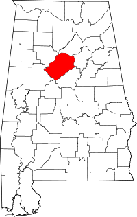 | |
| Towns | ||
| CDPs | ||
| Unincorporated communities | ||
| Former towns | ||
| Footnotes | ‡This populated place also has portions in an adjacent county or counties | |
Municipalities and communities of Walker County, Alabama, United States | ||
|---|---|---|
| Cities |  | |
| Towns | ||
| Unincorporated communities | ||
| Footnotes | ‡This populated place also has portions in an adjacent county or counties | |