Sula Islands
 | |
| Geography | |
|---|---|
| Location | South East Asia |
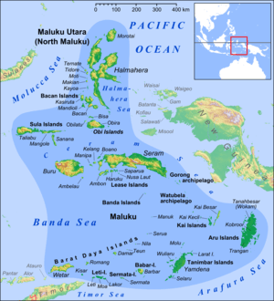
| Archipelago | Maluku Islands |
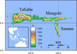
| Major islands | Mangole, Sanana and Taliabu |
| Area | 9,632.92 km2 (3,719.29 sq mi) |
| Administration | |
|
Indonesia | |
| Province | North Maluku |
| Largest settlement | Sanana |
| Demographics | |
| Population | 132,070 (2010 Census) |
| Pop. density | 13.71 /km2 (35.51 /sq mi) |

The Sula Islands (Indonesian: Kepulauan Sula) are a group of islands in North Maluku in Indonesia. Its three main islands are Mangole, Sanana (officially Sula Besi or Xulla Besi) and Taliabu, with smaller islands Lifamatola and Seho. Until 2013 the whole group was administered as Sula Archipelago Regency (Kabupaten Kepulauan Sula), with its administrative capital at Sanana on the island of the same name; its area is 9,632.92 km2 and population 132,070 (at the 2010 census). However, in 2013 Taliabu Island was separated from Kepulauan Sula Regency and formed into a new Regency.
Pre-Indonesian Independence saw the Sula Islands also known as the Xulla Islands, with Taliabo as Xulla Taliabo, Sanana as Xulla Bessi, and Mangola as Xulla Mangola.[1]
Administration
Following the removal of 7 districts to create a separate Taliabu Island Regency (Pulau Taliabu) in 2013, the residual Sula Archipelago Regency was divided into 12 districts (kecamatan), tabulated below with their 2010 Census population.
| Name | English name | Population Census 2010 |
|---|---|---|
| Mangole Barat | West Mangole | 7,084 |
| Mangole Selatan | South Mangole | 4,665 |
| Mangole Tengah | Central Mangole | 6,381 |
| Mangole Timur | East Mangole | 4,301 |
| Mangole Utara | North Mangole | 10,115 |
| Mangole Utara Timur | Northeast Mangole | 3,777 |
| Mangole Island | (total) | 36,323 |
| Sanana | 25,183 | |
| Sanana Utara | North Sanana | 5,675 |
| Sula Besi Barat | West Sula Besi | 4,707 |
| Sula Besi Selatan | South Sula Besi | 4,298 |
| Sula Besi Tengah | Central Sula Besi | 5,929 |
| Sula Besi Timur | East Sula Besi | 3,100 |
| Sula Besi Island | (total) | 48,892 |
| Sulu Archipelago Regency | 85,215 | |
| Lede | 5,977 | |
| Taliabu Barat | West Taliabu | 9,027 |
| Taliabu Barat Laut | Northwest Taliabu | 4,079 |
| Taliabu Selatan | South Taliabu | 8,738 |
| Taliabu Timur | East Taliabu | 3,542 |
| Taliabu Timur Selatan | Southwest Taliabu | 5,066 |
| Taliabu Utara | North Taliabu | 10,880 |
| Taliabu Island Regency | 47,309 |
History
The Dutch built a fort on Sanana in 1652. Wallace visited the islands during an ornithological expedition in 1862.[2]

Economy
According to government data Sula Islands District's food crops include vegetables, groundnuts, cassava, sweet potatoes, durian, mangosteen and mango. As of 2005 the area of agriculturally active land was 24743.56 hectares with production amounting to 33,608.62 tons per year. Taliabu-Sanana District is the main producer of cloves, nutmeg, cocoa, copra and other coconut products. Fishery production is very diverse with and estimated sustainable potential of 40,273.91 tonnes per year of which only 22.8 percent is currently exploited. Forestry is considered a potential industry with the natural forest-based Classification Map TGHK RTRWP suggesting a forest area of 471,951.53 hectares, but much of this is protected or hard to access, due to steep slopes and transportation logistics, and the islands' main plywood company, PT Barito Pacific Timber Group (in Falabisahaya, West Mangole) has closed. Industrial activity is very limited. There is a gold mine in East Mangoli District (at Waitina and Kawata) and coal mines are located in the peninsula of West Sula Besi District, East Taliabu and Sub Sanana (Wai Village Ipa). Reserves of coal are estimated around 10.4 million tonnes.
Fauna
The following species are native to the Sula Islands:
- Babirusa (Babyrousa babyrussa)
- Strigocuscus pelengensis
- Rattus elaphinus
- Acerodon celebensis
- Cynopterus brachyotis
- Dobsonia viridis
- Macroglossus minimus
- Nyctimene cephalotes
- Pteropus caniceps
- Rousettus celebensis
- Thoopterus nigrescens
- Emballonura alecto
- Hipposideros cervinus
- Miniopterus pusillus
- Megapodius bernsteinii (Gosong Sula), status vulnerable[3]
Introduced species include
- Asian house shrew
- Wild boar (Sus scrofa)
- Polynesian rat (Rattus exulans)
References
- ↑ Goodall, George (Editor)(1943) Philips' International Atlas London, George Philip and Son map 'East Indies' pp.91-92
- ↑ Wallace's list of birds spotted in the Sulu Islands, 1862
- ↑ http://www.antaranews.com/en/news/72587/more-indonesian-bird-species-nearing-extinction
External links
- Tourist guide to the Sula Islands
- Investment Coordinating Board (BKPM) Profile of the Sula Islands
- Investment Prospects in Sula (in Indonesian)
Regencies and cities of North Maluku | ||
|---|---|---|
Capital: Sofifi | ||
| Regencies | ||
| Cities | ||
Coordinates: 1°52′S 125°22′E / 1.867°S 125.367°E