Sula, Møre og Romsdal
| Sula kommune | |||
|---|---|---|---|
| Municipality | |||
 | |||
| |||
 Sula within Møre og Romsdal | |||
| Coordinates: 62°25′29″N 06°12′22″E / 62.42472°N 6.20611°ECoordinates: 62°25′29″N 06°12′22″E / 62.42472°N 6.20611°E | |||
| Country | Norway | ||
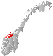
| County | Møre og Romsdal | ||
| District | Sunnmøre | ||
| Administrative centre | Langevåg | ||
| Government | |||
| • Mayor (2011) | Geir Ove Vegsund (H) | ||
| Area | |||
| • Total | 58.72 km2 (22.67 sq mi) | ||
| • Land | 57.27 km2 (22.11 sq mi) | ||
| • Water | 1.45 km2 (0.56 sq mi) | ||
| Area rank | 417 in Norway | ||
| Population (2013) | |||
| • Total | 8,397 | ||
| • Rank | 135 in Norway | ||
| • Density | 146.6/km2 (380/sq mi) | ||
| • Change (10 years) | 15.0 % | ||
| Demonym(s) | Sulalending[1] | ||
| Time zone | CET (UTC+1) | ||
| • Summer (DST) | CEST (UTC+2) | ||
| ISO 3166 code | NO-1531 | ||
| Official language form | Nynorsk | ||
| Website |
www | ||
|
| |||

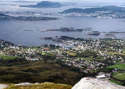
![]() Sula is a municipality in Møre og Romsdal county, Norway. It is part of the Sunnmøre district. The administrative centre is the village of Langevåg. Other villages include Solevåg, Fiskarstrand, Veibust, Leirvågen, and Mauseidvågen. Sula is one of the most densely populated municipalities in Møre og Romsdal county, and it is part of the Ålesund Region since it is just south of the city of Ålesund. The municipality encompasses the island of Sula and the many small surrounding islets.
Sula is a municipality in Møre og Romsdal county, Norway. It is part of the Sunnmøre district. The administrative centre is the village of Langevåg. Other villages include Solevåg, Fiskarstrand, Veibust, Leirvågen, and Mauseidvågen. Sula is one of the most densely populated municipalities in Møre og Romsdal county, and it is part of the Ålesund Region since it is just south of the city of Ålesund. The municipality encompasses the island of Sula and the many small surrounding islets.
General information


Originally, most of the island of Sula was part of the old Borgund Municipality and the small southwestern part of the island was part of Ulstein Municipality (see formannskapsdistrikt). On 1 July 1958, the southwestern part of Sula island was transferred to Borgund Municipality. In 1968, Borgund Municipality (including all of the island of Sula) was merged with the town of Ålesund to form the large Ålesund Municipality. On 1 January 1977, the entire island of Sula and the many small islets around it were separated from Ålesund Municipality to become a separate municipality. The initial population of the new Sula Municipality was 6,302.[2]
Name
The municipality is named after the island of Sula. The name is probably identical with the word sula which means "cleft", probably referring to the cleft between the twin peaks of Rundehornet and Vardane.
Coat-of-arms
The coat-of-arms is from modern times. They were granted on 16 December 1983. The arms show a silver and blue figure which represents the cleft of the island.[3]
Churches
The Church of Norway has one parish (sokn) within the municipality of Sula. It is part of the Nordre Sunnmøre deanery in the Diocese of Møre.
| Parish (Sokn) | Church Name | Location of the Church | Year Built |
|---|---|---|---|
| Sula | Langevåg Church | Langevåg | 1948 |
| Indre Sula Church | Mauseidvåg | 1984 |
Geography
Sula Municipality includes one main island and many small surrounding islets. It is bordered by the Sulafjorden strait to the west, the Storfjorden to the south, the Hessafjorden and Borgundfjorden to the north, and the narrow Vegsundet strait to the east. The only road access to the island is the European route E39 highway bridge over the Vegsundet.
The natural environment is typically coastal with a sparse forest. The landscape is mostly rocky with heather covering the ground. The highest elevation is the 776-metre (2,546 ft) tall mountain Vardane. Its neighbouring municipalities are all separated from it by sea; Hareid Municipality to the west, Ørsta Municipality to the south, Giske Municipality to the northwest, and Ålesund Municipality to the north and east.
Culture
Sula is noted for strong traditions in the field of music. Nils Petter Molvær grew up in Langevåg. Also, the community harbours a strong maritime heritage. The influence of neighbouring city of Ålesund is strong; many live in Sula while working in Ålesund, which is a short ferry ride or a longer car ride away.
Economy
Manufacturing and production is the most important economical sector. Shipyards, fish processing, textile manufacturing, and furniture production are especially vital. The most famous clothing brand from Sula is Devold of Norway, with high quality woolen sweaters and underwear.
Transportation

Transportation in the municipality includes the European route E39 highway and several minor highways. The E39 highway enters Sula from the north (Ålesund Municipality) and it crosses the bridge at Vegsundet and continues west and then south to the Solevågen ferry quay where there are regular ferry routes to Festøya in Ørsta Municipality, across the Storfjorden. Also, there is a ferry connection in southwestern Sula Municipality. This ferry has regular routes across the Sulafjorden from Sulasund to the village of Hareid on the island of Hareidlandet in Hareid Municipality.
References
- ↑ "Navn på steder og personer: Innbyggjarnamn" (in Norwegian). Språkrådet. Retrieved 2015-12-01.
- ↑ Jukvam, Dag (1999). "Historisk oversikt over endringer i kommune- og fylkesinndelingen" (PDF) (in Norwegian). Statistisk sentralbyrå.
- ↑ "Kommunevåpenet". Sula Kommune. Retrieved 2008-10-19.
External links
 Media related to Sula, Norway at Wikimedia Commons
 Møre og Romsdal travel guide from Wikivoyage