Sugarloaf Mountain (Maryland)
| Sugarloaf Mountain | |
|---|---|
 Sugarloaf Mountain, sunset | |
| Highest point | |
| Elevation | 1,282 ft (391 m) |
| Geography | |
| Location | Frederick County, Maryland |
| Parent range | Blue Ridge Mountains (outlier) |
| Geology | |
| Age of rock | approx. 500 million years[1] |
| Mountain type | Monadnock |
| Climbing | |
| Easiest route |
Stairway and trail to summit |
| Designated | June 1969 |
Sugarloaf Mountain is a small (1,282 foot; 391 m) mountain and park about 10 miles (16 km) south of Frederick, Maryland, USA. The closest village is Barnesville, located nearly at the foot of the mountain. The peak of this relatively low mountain is approximately 800 feet (244 m) higher than the surrounding farmland. It is visible from many parts of northern Montgomery County and southern Frederick County, notably from I-270 north of the town of Germantown. Because of its geological and natural history interest, it was designated a National Natural Landmark in 1969. It is a notable example of an admission-free, privately owned scenic park.
History
During the Maryland Campaign of the American Civil War in 1862, Union forces occupying the summit, which was being used as an observation and signal station, first spotted the Army of Northern Virginia on September 5 as it crossed the Potomac River into Maryland. The following morning as the small Union force on the mountain began to retreat in the face of the oncoming Confederate Army, they ran into the unsuspecting 1st North Carolina Infantry and a small skirmish ensued. The Union force was able to escape, but it was later caught by Confederate cavalry at Urbana.[2]
In the early 20th century Chicago businessman Gordon Strong bought substantial land holdings on and around the mountain. In 1925, the architect Frank Lloyd Wright, on commission from Strong, proposed an automobile objective development for the top of the mountain, but that was never carried out.
President Franklin D. Roosevelt, briefly considered using Sugarloaf as his Presidential retreat, but he was persuaded by Strong to choose the nearby Shang-Ri-La site on the Catoctin Mountain, which today is known as Camp David.
| Sugarloaf Mountain, Maryland | |
| National Natural Landmark | |
 Sugarloaf Mountain, Maryland | |
| Country | United States |
|---|---|
| State | Maryland |
| Coordinates | 39°16′9.15″N 77°23′42.89″W / 39.2692083°N 77.3952472°WCoordinates: 39°16′9.15″N 77°23′42.89″W / 39.2692083°N 77.3952472°W |
| Established | June 1969 |
| Owner | Private owner |
| IUCN category | ? |
| Nearest city | Barnesville, Maryland |
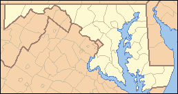 Location of Sugarloaf Mountain in Maryland | |
| Website: Stronghold, Inc. Sugarloaf Mountain | |
Strong set up a trust fund in 1947 that maintains a trail system and other tourist facilities at Sugarloaf Mountain. The mountain and its immediate environs continue to be open to the public, but they are privately owned by Stronghold, Incorporated.
Geology
Sugarloaf Mountain is an example of a monadnock — an isolated hill or small mountain rising abruptly from gently sloping or level surrounding land. It appears to be either an outlier to the east of the main mass of Catoctin Mountain, or a root remnant of the ancient Appalachian land mass.
The bedrock is the Lower Cambrian Sugarloaf Mountain Quartzite, a massive white quartzite interbedded with softer sericitic quartzite, slate, and phyllite. The formation is divided into upper, middle, and lower members.[3]
Tourism
Sugarloaf Mountain is an area tourist attraction, free of an admission charge, and open to the public. Activities include hiking, rock climbing, picnicking, and sightseeing. The mountain is known to locals for its scenic views.
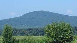
 The scenic overlook at Sugarloaf Mountain
- Seen from 2.5 miles (4 km) to the east
 View at the top during fall
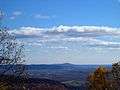 Sugarloaf Mountain as seen from Maryland Heights
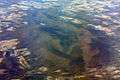 Oblique air photo of Sugarloaf Mountain, facing southwest, January 2009
 The base of the mountain, as seen from the top.
References
- ↑ Choukas-Bradley, Melanie. Sugarloaf: The Mountains History, Geology, and Natural Lore. University of Virginia Press 2003 ISBN 0-8139-2168-6 p. 11
- ↑ Sugarloaf Mountain - A Signalman’s Lot Marker
- ↑ Geologic Map of the Frederick 30' x 60' Quadrangle, Maryland, Virginia, and West Virginia, Scientific Investigations Map 2889, USGS, S. Southworth et al., 2007
External links
- Official website
- Page by the Potomac Appalachian Trail Club
- Trail map
- Brief overview of climbing areas
- "Sugar Loaf Mountain". Geographic Names Information System. United States Geological Survey.
- "Sugarloaf Mountain Natural Area". Geographic Names Information System. United States Geological Survey.
- Scotford, David M. (1951). "Structure of the Sugarloaf Mountain Area, Maryland, As a Key to Piedmont Stratigraphy". Geological Society of America Bulletin. 62 (1): 45–76. doi:10.1130/0016-7606(1951)62[45:SOTSMA]2.0.CO;2.