Sugar Creek, Missouri
| Sugar Creek, Missouri | |
|---|---|
| City | |
 Location of Sugar Creek, Missouri | |
| Coordinates: 39°7′5″N 94°26′8″W / 39.11806°N 94.43556°WCoordinates: 39°7′5″N 94°26′8″W / 39.11806°N 94.43556°W | |
| Country | United States |
| State | Missouri |
| Counties | Jackson, Clay |
| Area[1] | |
| • Total | 11.33 sq mi (29.34 km2) |
| • Land | 10.54 sq mi (27.30 km2) |
| • Water | 0.79 sq mi (2.05 km2) |
| Elevation | 820 ft (250 m) |
| Population (2010)[2] | |
| • Total | 3,345 |
| • Estimate (2012[3]) | 3,341 |
| • Density | 317.4/sq mi (122.5/km2) |
| Time zone | Central (CST) (UTC-6) |
| • Summer (DST) | CDT (UTC-5) |
| ZIP code | 64054 |
| Area code(s) | Area code 816 |
| FIPS code | 29-71368[4] |
| GNIS feature ID | 0727219[5] |
Sugar Creek is a city in Clay and Jackson counties in the U.S. state of Missouri. The population was 3,345 at the 2010 census.
Geography
Sugar Creek is located at 39°07′05″N 94°26′08″W / 39.118014°N 94.435630°W (39.118014, -94.435630).[6]
According to the United States Census Bureau, the city has a total area of 11.33 square miles (29.34 km2), of which, 10.54 square miles (27.30 km2) is land and 0.79 square miles (2.05 km2) is water.[1]
History

Like many cities along the Missouri River, Sugar Creek shows evidence of having once been the home of the Osage people. The city takes its name from nearby Sugar Creek.[7]
On June 25, 1804, the Lewis and Clark Expedition camped on an island[8] in the Missouri River opposite what is modern day Sugar Creek.
In the mid-1800s, the area now known as Sugar Creek served as an important link in America's westward expansion. Known as Upper Independence Landing originally, the territory along the Missouri River served as a port to receive supplies for early pioneers.[9] It was renamed Wayne City Landing after an army lieutenant, Anthony Wayne.[9] Wayne City, which is now on the national historic register, also received travelers who were headed west along the Oregon, California and Santa Fe Trails. In 1850, the first railroad west of the Mississippi River was constructed to join Wayne City and nearby Independence, Missouri.
From the early 1890s to the 1930s, the Sugar Creek area was home to a first-class pleasure resort, Fairmount Park. Among the park's attractions were a hotel, theater, lake, and carnival rides, including a roller coaster that at one time was the world's largest. A streetcar line brought visitors to the park from nearby Kansas City.
In 1903, Standard Oil of Indiana purchased land at the northern edge of the city. A new oil refinery was opened a year later and quickly spurred growth in the townsite of Sugar Creek. A number of immigrants from Eastern Europe came to work in the plant, and by 1918, the town had grown to more than 800 residents.

Shortly after World War I, businessmen and residents founded the Sugar Creek Improvement Association. The Association installed streetlights, set city limits and petitioned for incorporation as a city. On November 15, 1920, the City of Sugar Creek was officially born. The new town consisted of 564 acres (2.28 km2) and had a population of around 1,800 residents. The city continued to grow and prosper in its early years. In 1958, an additional 294 acres (1.19 km2) were annexed on the eastern side of the city, bringing new opportunities for development.
The Liberty Bend Bridge, in northeastern Sugar Creek, carries Route 291 across the Missouri River. The northbound bridge was built in 1949 when a new channel for the river was completed, and replaced the 1927 Liberty Bend Bridge which was about two miles to the north and crossed over the former river channel. Construction began in 1996 on the southbound bridge, which opened in 2001, and the northbound bridge was completely rehabilitated. It was part of an upgrade that changed Route 291 into a four-lane divided highway.
In the 2000s, BP America was involved in over 24 multimillion-dollar lawsuits for extreme polluting and causing unusual cancers in many people caused by its predecessors Amoco and Standard Oil at its Sugar Creek refinery[10] which closed in 1982.[11]
Demographics
| Historical population | |||
|---|---|---|---|
| Census | Pop. | %± | |
| 1930 | 1,657 | — | |
| 1940 | 1,638 | −1.1% | |
| 1950 | 1,858 | 13.4% | |
| 1960 | 2,663 | 43.3% | |
| 1970 | 4,755 | 78.6% | |
| 1980 | 4,305 | −9.5% | |
| 1990 | 3,982 | −7.5% | |
| 2000 | 3,839 | −3.6% | |
| 2010 | 3,345 | −12.9% | |
| Est. 2015 | 3,320 | [12] | −0.7% |
2010 census
As of the census[2] of 2010, there were 3,345 people, 1,420 households, and 852 families residing in the city. The population density was 317.4 inhabitants per square mile (122.5/km2). There were 1,627 housing units at an average density of 154.4 per square mile (59.6/km2). The racial makeup of the city was 90.9% White, 2.5% African American, 0.5% Native American, 0.6% Asian, 0.6% Pacific Islander, 2.4% from other races, and 2.5% from two or more races. Hispanic or Latino of any race were 7.1% of the population.
There were 1,420 households of which 27.5% had children under the age of 18 living with them, 39.0% were married couples living together, 14.9% had a female householder with no husband present, 6.1% had a male householder with no wife present, and 40.0% were non-families. 31.8% of all households were made up of individuals and 11.2% had someone living alone who was 65 years of age or older. The average household size was 2.36 and the average family size was 2.96.
The median age in the city was 41.2 years. 21.4% of residents were under the age of 18; 8.8% were between the ages of 18 and 24; 24.1% were from 25 to 44; 30.4% were from 45 to 64; and 15.4% were 65 years of age or older. The gender makeup of the city was 50.3% male and 49.7% female.
2000 census
As of the census[4] of 2000, there were 3,839 people, 1,633 households, and 1,048 families residing in the city. The population density was 465.0 people per square mile (179.4/km2). There were 1,753 housing units at an average density of 212.4 per square mile (81.9/km2). The racial makeup of the city was 93.83% White, 0.81% African American, 0.78% Native American, 0.52% Asian, 0.44% Pacific Islander, 1.67% from other races, and 1.95% from two or more races. Hispanic or Latino of any race were 4.06% of the population.
There were 1,633 households out of which 24.8% had children under the age of 18 living with them, 46.2% were married couples living together, 12.1% had a female householder with no husband present, and 35.8% were non-families. 30.0% of all households were made up of individuals and 10.4% had someone living alone who was 65 years of age or older. The average household size was 2.35 and the average family size was 2.87.
In the city the population was spread out with 22.1% under the age of 18, 8.5% from 18 to 24, 29.9% from 25 to 44, 24.7% from 45 to 64, and 14.8% who were 65 years of age or older. The median age was 39 years. For every 100 females there were 99.2 males. For every 100 females age 18 and over, there were 98.5 males.
The median income for a household in the city was $39,967, and the median income for a family was $46,208. Males had a median income of $35,341 versus $23,686 for females. The per capita income for the city was $20,784. About 10.3% of families and 10.8% of the population were below the poverty line, including 15.2% of those under age 18.
Education
The majority of the city is within the Independence Public School District. The far eastern portions of Sugar Creek are in the Fort Osage School District. Schools serving Sugar Creek residents include: Elm Grove, Sugar Creek and Mill Creek Elementary Schools; Bingham Middle School, Nowlin Middle School and Osage Trail Middle School; and Fort Osage High School, Van Horn High School and William Chrisman High School. Prior to Fall 2008, some of Sugar Creek and its schools were within the Kansas City, Missouri School District.[14]
Kansas City Public Library operates the Sugar Creek Library.
See also
- Big Sugar Creek which is also in Missouri.
References
- 1 2 "US Gazetteer files 2010". United States Census Bureau. Retrieved 2012-07-08.
- 1 2 "American FactFinder". United States Census Bureau. Retrieved 2012-07-08.
- ↑ "Population Estimates". United States Census Bureau. Retrieved 2013-05-30.
- 1 2 "American FactFinder". United States Census Bureau. Retrieved 2008-01-31.
- ↑ "US Board on Geographic Names". United States Geological Survey. 2007-10-25. Retrieved 2008-01-31.
- ↑ "US Gazetteer files: 2010, 2000, and 1990". United States Census Bureau. 2011-02-12. Retrieved 2011-04-23.
- ↑ "Jackson County Place Names, 1928–1945 (archived)". The State Historical Society of Missouri. Retrieved 16 October 2016.
- ↑ The Journals of the Lewis and Clark Expedition, University of Nebraska, Lincoln
- 1 2 Piland, Richard Newton (2010). "Introduction". Sugar Creek. Arcadia Publishing. p. 7. ISBN 9780738584126.
- ↑ "BP to Settle Sugar Creek Refinery Lawsuits". Convenience Store News. Sugar Creek, Missouri. 30 March 2008. Retrieved 22 April 2014.
- ↑ Grenz, Chris (26 October 2006). "BP settles case on pollution at Sugar Creek". Kansas City Business Journal. Retrieved 22 April 2014.
- ↑ "Annual Estimates of the Resident Population for Incorporated Places: April 1, 2010 to July 1, 2015". Retrieved July 2, 2016.
- ↑ "Census of Population and Housing". Census.gov. Retrieved June 4, 2015.
- ↑ Forum explores potential transfer of seven KC schools to Independence district. | Kansas City Star (Kansas City, MO) (September, 2007)
External links
Municipalities and communities of Clay County, Missouri, United States | ||
|---|---|---|
| Cities | 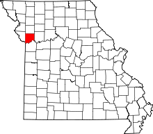 | |
| Villages | ||
| Townships |
| |
| Unincorporated communities | ||
| Footnotes | ‡This populated place also has portions in an adjacent county or counties | |
Municipalities and communities of Jackson County, Missouri, United States | ||
|---|---|---|
| Cities | 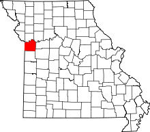 | |
| Villages | ||
| Townships | ||
| Unincorporated communities | ||
| Footnotes | ‡This populated place also has portions in an adjacent county or counties | |
Kansas City metropolitan area's cities and counties | ||
|---|---|---|
| Central city |  | |
| Largest cities (over 100,000 in 2000) | ||
| Medium-sized cities (10,000 to 100,000 in 2000) | ||
| Smaller Cities (between 5,000 and 9,900 in 2010) | ||
| Counties | ||