Sucre (state)
This article is about the state in Venezuela. For the location in Barinas, see Antonio José de Sucre, Venezuela. For other uses, see Sucre (disambiguation).
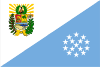
| Sucre | |||
|---|---|---|---|
| State of Venezuela | |||
| |||
| Anthem: Himno del Estado Sucre | |||
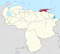 Location within Venezuela | |||
| Country | Venezuela | ||
| Created | 1909 | ||
| Capital | Cumaná | ||
| Government | |||
| • Governor | Luis Acuña (2012–present) | ||
| Area | |||
| • Total | 11,800 km2 (4,600 sq mi) | ||
| Area rank | 14th | ||
| 1.29% of Venezuela | |||
| Population (2011 census) | |||
| • Total | 896,921 | ||
| • Rank | 10th | ||
| 3.34% of Venezuela | |||
| Time zone | UTC-04:30 | ||
| ISO 3166 code | VE-R | ||
| Emblematic tree | Roble (Oak) (Platymiscium diadelphum) | ||
| Website |
www | ||

Sucre State (Spanish: Estado Sucre, IPA: [esˈtaðo ˈsukɾe]) is one of the 23 states of Venezuela. The state capital is Cumaná. Sucre State covers a total surface area of 11,800 km² and, as of the 2011 census, had a population of 896,921. The most important river in the state is the Manzanares River.
Municipalities
- Andrés Eloy Blanco (Casanay)
- Andrés Mata (San José de Aerocuar)
- Arismendi (Río Caribe)
- Benítez (El Pilar)
- Bermúdez (Carúpano)
- Bolívar (Marigüitar)
- Cajigal (Yaguaraparo)
- Cruz Salmerón Acosta (Araya)
- Libertador (Tunapuy)
- Mariño (Irapa)
- Mejía (San Antonio del Golfo)
- Montes (Cumanacoa)
- Ribero (Cariaco)
- Sucre (Cumaná)
- Valdez (Güiria)
Population
Race and ethnicity
According to the 2011 Census, the racial composition of the population was:[1]
| Racial composition | Population | % |
|---|---|---|
| Mestizo | N/A | 54.7 |
| White | 375,688 | 38.5 |
| Black | 47,815 | 4.9 |
| Other race | N/A | 1.9 |
Notable People
- Antonio José de Sucre "Gran Mariscal de Ayacucho"
- Cruz Salmerón Acosta, poet.
- Andrés Eloy Blanco, poet.
- Juana Dolores Valdéz, poet.
- Edilio Navarro, sculptor.
- Francisco del Valle Álvarez Agreda, singer.
- Pastora Salazar Suniaga, singer.
- Bernardo Bermúdez.
- Atanasio Antonio Tineo, musician.
- General Francisco Mejía.
- Doctor Diego Carbonell.
- Gualberto Ibarreto, singer.
- Eladio Lárez, TV host
- José Antonio Ramos Sucre, poet.
- Maria Rodríguez, singer-songwriter.
- Francisco Sánchez, swimmer.
- Irene Esser, Miss Universe 2012 2nd runner up.
- Wolfgang Larrazábal, rear admiral president of Venezuela (1958)
Gallery
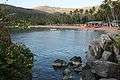 View of Playa Colorada
 Beach of Cumaná
 Castle of Araya
See also
References
- ↑ "Resultado Básico del XIV Censo Nacional de Población y Vivienda 2011 (Mayo 2014)" (PDF). Ine.gov.ve. p. 29. Retrieved 8 September 2015.
External links
Coordinates: 10°38′44″N 63°02′20″W / 10.64556°N 63.03889°W
This article is issued from Wikipedia - version of the 8/7/2016. The text is available under the Creative Commons Attribution/Share Alike but additional terms may apply for the media files.