Subdivisions of Nigeria

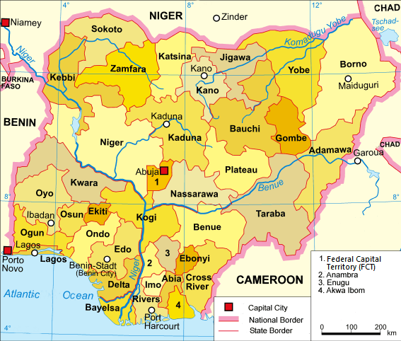
Nigeria is divided into thirty-six states and one Federal Capital Territory, which are further sub-divided into 774 Local Government Areas (LGAs). The plethora of states, of which there were only three at independence, reflect the country's tumultuous history and the difficulties of managing such a heterogeneous national entity at all levels of government.


A clickable map of Nigeria exhibiting its 36 states and the federal capital territory.
Niger Zinder Niamey Burkina Faso Benin Atlantic Ocean Cameroon Porto Novo Garoua Chad Chad Lake Chad Abuja Sokoto State Kebbi State Zamfara State Katsina State Jigawa State Yobe State Borno State Kano State Bauchi State Gombe State Adamawa State Plateau State Taraba State Kaduna State Nassarawa State Benue State Niger State Kwara State Oyo State Ogun State Lagos State Kogi State Osun State Ekiti State Ondo State Edo State Ebonyi State Delta State Bayelsa State Rivers State Imo State Abia State Cross River State Federal Capital Territory (Nigeria) Federal Capital Territory (Nigeria) Anambra State Anambra State Enugu State Enugu State Akwa Ibom State Akwa Ibom State Port Harcourt Benin City Lagos Ibadan Kaduna Kano MaiduguriA clickable map of Nigeria exhibiting its 36 states and the federal capital territory.
About this image
States
  1. Abia
  2. Adamawa
  3. Anambra
  4. Akwa Ibom
  5. Bauchi
  6. Bayelsa
  7. Benue
  8. Borno
  9. Cross River
  10. Delta
  11. Ebonyi
  12. Enugu
  1. Edo
  2. Ekiti
  3. Gombe
  4. Imo
  5. Jigawa
  6. Kaduna
  7. Kano
  8. Katsina
  9. Kebbi
  10. Kogi
  11. Kwara
  12. Lagos
  1. Nasarawa
  2. Niger
  3. Ogun
  4. Ondo
  5. Osun
  6. Oyo
  7. Plateau
  8. Rivers
  9. Sokoto
  10. Taraba
  11. Yobe
  12. Zamfara
Territory
Federal Capital Territory (FCT)

References

    This article is issued from Wikipedia - version of the 2/23/2015. The text is available under the Creative Commons Attribution/Share Alike but additional terms may apply for the media files.