Stronsay
| Norse name | Strjónsey |
|---|---|
| Meaning of name | Old Norse for "good fishing and farming island"[1][2] |
 An aerial view of Whitehall, with Grice Ness at the end of Stronsay's north-eastern peninsula | |
| Location | |
 Stronsay Stronsay shown within Orkney | |
| OS grid reference | HY669239 |
| Physical geography | |
| Island group | Orkney |
| Area | 3,275 hectares (13 sq mi) |
| Area rank | 27 [3] |
| Highest elevation | Burgh Hill 44 metres (144 ft) |
| Administration | |
| Sovereign state | United Kingdom |
| Country | Scotland |
| Council area | Orkney Islands |
| Demographics | |
| Population | 349[4] |
| Population rank | 26 [3] |
| Pop. density | 10.7 people/km2[1][4] |
| Largest settlement | Whitehall |
| References | [6][7] |
Stronsay is an island in Orkney, off the north coast of Scotland. It is 3,275 hectares (13 sq mi) in size, and 44 metres (144 feet) at its highest point and has a usually resident population of 349. The main village is Whitehall, home to a heritage centre.
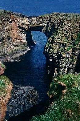
Sights on the island include the Vat of Kirbister, a natural arch described as the "finest in Orkney"[1] and various seabirds amongst which are Arctic terns.
Geography and geology
As with most of Orkney, Stronsay is made up of Old Red Sandstone which has produced a fine soil in many places.[1] It is generally low lying.
With an area of 33 square kilometres (13 sq mi) it is the seventh largest of the Orkney Islands. Surrounding small islands include Linga Holm, Papa Stronsay, the Holm of Huip (named after a district in north west Stronsay) and the Holms of Spurness. To the north is Sanday, to the north west Eday, Shapinsay and Mainland Orkney to the south west, and Auskerry due south.
History
Prehistory
Two flint arrowheads discovered at a site investigated by Orkney College in April 2007 are believed to date from the late Paleolithic or early Mesolithic periods some 10-12,000 years ago. They were found amongst a scattered collection of other tools on a farm. If confirmed, they could be the earliest human artifacts found in Scotland.[8]
18th and 19th centuries
The island is now agricultural, but during the 18th and 19th centuries, kelp collection and herring curing employed up to five thousand people. The population, which is high for a Scottish island, was over a thousand for the entire 19th century through the mid-20th century, with the 1891 census recording a population of 1275 people, excluding seasonal itinerants involved in the herring industry.[1]
The kelp burning industry was started by James Fea of Whitehall in 1727,[1] and thrived during the remainder of the 18th century, lasting into the early 19th century; some of the kiln ruins can still be seen.
The Stronsay beast was a mysterious, decomposing corpse of a sea-creature that was stranded in 1808. The carcass measured 55 feet (16.8 m) in length, with the "neck" 15 feet and the circumference of the body 10 feet.[9] The corpse created a great stir, with some proclaiming it a sea serpent, but others have claimed it was a decayed basking shark.
Present day
The usual resident population of the island in 2011 was 349,[4] compared to 342 in 2001.[10] Orkney Ferries sail from Whitehall to Kirkwall on the Orkney Mainland, and planes fly there from the island's airstrip. There is one school on the island which is for both primary and secondary pupils.
Moncur Memorial Church is the Church of Scotland centre of worship on Stronsay and there is a Catholic chapel in Whitehall, which is part of the Diocese of Aberdeen.[11]
Wildlife
While the landscape has very few trees, the fertile soil supports a wide variety of wild flowers including oysterplant, frog orchids, adder's tongue, and also a naturalised population of Patagonian ragwort.[1]
There are a wide variety of birds on the island, and birdwatchers have recorded many rarities. Common species include whooper swan, various ducks and geese including the greater white-fronted goose, as well as common redshank, common snipe, common quail, great skua, corn bunting and corncrake, the last of which is rare in Scotland.
The more unusual occasional visitors which have been recorded include:
- American golden plover
- Arctic redpoll
- Pied wheatear
- Rustic bunting
- Scarlet rosefinch
- Tawny pipit
- Various warblers including: Radde's warbler, marsh warbler and subalpine warbler.[1]
See also
- Papa Stronsay - a nearby islet which belongs to the Transalpine Redemptorists, a traditionalist Catholic organisation.
Notes
- 1 2 3 4 5 6 7 8 Haswell-Smith (2004) p. 370-72
- ↑ Orkney Placenames Orkneyjar. Retrieved 28. May 2012.
- 1 2 Area and population ranks: there are c. 300 islands over 20 ha in extent and 93 permanently inhabited islands were listed in the 2011 census.
- 1 2 3 National Records of Scotland (15 August 2013) (pdf) Statistical Bulletin: 2011 Census: First Results on Population and Household Estimates for Scotland - Release 1C (Part Two). "Appendix 2: Population and households on Scotland’s inhabited islands". Retrieved 17 August 2013.
- ↑ Ordnance Survey: Landranger map sheet 5 Orkney (Northern Isles) (Map). Ordnance Survey. 2008. ISBN 9780319228111.
- ↑ Anderson, Joseph (Ed.) (1893) Orkneyinga Saga. Translated by Jón A. Hjaltalin & Gilbert Goudie. Edinburgh. James Thin and Mercat Press (1990 reprint). ISBN 0-901824-25-9
- ↑ Pedersen, Roy (January 1992) Orkneyjar ok Katanes (map, Inverness, Nevis Print)
- ↑ Ross, John (5 October 2007) "Orkney arrowheads find points to Scotland's earliest settlement". Edinburgh. The Scotsman.
- ↑ Newton, Michael (2005). "Stronsay Beast". Encyclopedia of Cryptozoology: A Global Guide. McFarland & Company, Inc. pp. 442–443. ISBN 0-7864-2036-7.
- ↑ General Register Office for Scotland (28 November 2003) Scotland's Census 2001 – Occasional Paper No 10: Statistics for Inhabited Islands. Retrieved 26 February 2012.
- ↑ "Stronsay" Visitorkney.com. Retrieved 25 August 2013.
References
- Haswell-Smith, Hamish (2004). The Scottish Islands. Edinburgh: Canongate. ISBN 978-1-84195-454-7.
External links
| Wikimedia Commons has media related to Stronsay. |
|  | ||||||||||||||||||||||||||||
|
| |||||||||||||||||||||||||||||
| |||||||||||||||||||||||||||||
| |||||||||||||||||||||||||||||
| |||||||||||||||||||||||||||||
| |||||||||||||||||||||||||||||
| |||||||||||||||||||||||||||||
| |||||||||||||||||||||||||||||
Coordinates: 59°07′N 2°36′W / 59.117°N 2.600°W