Strip District, Pittsburgh
| Strip District | |
|---|---|
| Neighborhood of Pittsburgh | |
|
Bustling Penn Avenue on a Saturday afternoon in summer. | |
 | |
| Coordinates: 40°27′00″N 79°59′06″W / 40.450°N 79.985°W | |
| Country | United States |
| State | Pennsylvania |
| County | Allegheny County |
| City | Pittsburgh |
| Area[1] | |
| • Total | 0.609 sq mi (1.58 km2) |
| Population (2010)[1] | |
| • Total | 616 |
| • Density | 1,000/sq mi (390/km2) |

The Strip District is a neighborhood in Pittsburgh, Pennsylvania in the United States. It is a one-half square mile area of land northeast of the central business district bordered to the north by the Allegheny River and to the south by portions of the Hill District. The Strip District runs between 13th and 33rd Streets and includes three main thoroughfares — Smallman St., Penn Ave., and Liberty Ave. — as well as various side streets.
History
In the early 19th century, the Strip District was home to many mills and factories as its location along the Allegheny River made for easy transportation of goods and shipping of raw materials. It was the home of the Fort Pitt Foundry, source of large cannon before and during the American Civil War, including a 20-inch (510 mm) bore Rodman Gun.[2] Early industrial tenants of the Strip District included U.S. Steel, Westinghouse, The Pittsburgh Reduction Company (ALCOA), and later The H.J. Heinz Company, famous ketchup and condiment manufacturer.
The shipping infrastructure built around the manufacturing companies attracted other types of merchants to set up shop in the Strip. By the early 20th century, the Strip District became a vibrant network of wholesalers—mostly fresh produce, meat, and poultry dealers. Soon, auction houses rose around the wholesale warehouses. Many restaurants and grocery stores opened to feed hungry shift workers at any hour of the day. By the 1920s, the Strip District was the economic center of Pittsburgh.
Today
By the mid-to-late 20th century, fewer of the Strip's products were being shipped by rail and boat, causing many produce sellers and wholesalers to leave the area for other space with easier access to highways, or where there was more land available for expansion. In the early 21st century, there are still several wholesalers and produce dealers in the Strip District, but some estimates say more than 80% of the produce industry left the area, preceded by the manufacturing plants and mills in the mid to late 20th century restructuring of industry. Today, many of the abandoned warehouses have been renovated as small specialty shops, restaurants, nightclubs, and bars. The historic St. Stanislaus Kostka Church, an 1891 landmark built in the ornate Polish Cathedral style, lies in the heart of the Strip District and served early generations of Polish immigrants.
Since the late 20th century, the area has developed into a historic market district with many ethnic food purveyors, some art studios, antique dealers, unique boutiques, and other businesses setting up shop where trains once delivered produce by the ton. The lack of weekday activity is in someways compensated by retail and leisure facilities which are used primarily on weekends. Particularly in the summer months, there are open-air farmers' markets, a range of street vendors and facilities to enjoy open air drinks. Residential developers have begun to convert old factory and warehouse buildings into apartments and lofts. Examples include the Armstrong Cork Factory, Brake House Lofts, and the Otto Milk Building. A mixed-use tower is planned for the Ayoob Fruit Warehouse site.
Uber has established an 'Advanced Technology Center' in the district. They maintain a fleet of Ford Fusion cars each equipped with 20 cameras, seven lasers and GPS and radar equipment. These enable the car to create a three-dimensional map utilising landmarks and other contextual information to keep track of its position. These constitute a fleet of driverless cars which are being tested in Pittsburgh. [3]
Surrounding and adjacent Pittsburgh neighborhoods
Downtown, Lower Lawrenceville, North Shore (via 16th Street Bridge across the Allegheny River), Polish Hill to the south, Troy Hill (via 16th Street Bridge across the Allegheny River)
Gallery
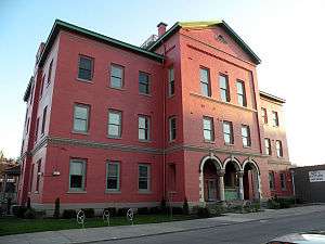 Springfield Public School, built in 1871, now the 31st Street Lofts.
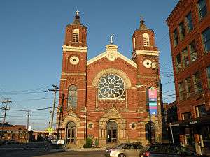 St. Stanislaus Kostka Church, built in 1891.
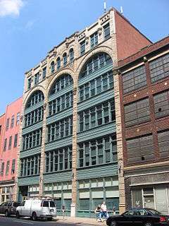 Byrnes & Kiefer Building, built in 1892.
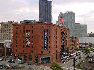 Chautauqua Lake Ice Company Warehouse, built in 1898, now the Heinz History Center.
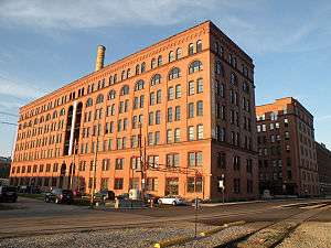 Armstrong Cork Company, built in 1901, now The Cork Factory Lofts.
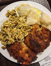 A plate of Polish Food from a deli in the Strip District
 A store selling Pittsburgh sports apparel.
 The original Primanti Brothers restaurant in the Strip District.
.jpg) Mural
Mural
See also
- Wholey's
- Pittsburgh Public Market
- Enrico Biscotti Company
- Simcoach Games
- Heinz History Center
- Primanti Brothers
References
- 1 2 "PGHSNAP 2010 Raw Census Data by Neighborhood". PGHSNAP Utility. Pittsburgh Department of City Planning. 2012. Retrieved 28 June 2013.
- ↑ "The Strip District: Rodman's Great Guns". Archived from the original on July 4, 2008. Retrieved 2008-07-05.
- ↑ Hook, leslie. "Uber's Pittsburgh pitch at a driverless future". Financial Times. Financial Times. Retrieved 17 September 2016.
Further reading
- Washington Post article
- Toker, Franklin (1994) [1986]. Pittsburgh: An Urban Portrait. Pittsburgh: University of Pittsburgh Press. ISBN 0-8229-5434-6.
- Kadushin, Raphael (August 2003). "15222: Come Hungry". National Geographic. pp. 114–122. Retrieved 2007-08-26.
External links
| Wikivoyage has a travel guide for Strip District & Lawrenceville. |
| Wikimedia Commons has media related to Strip District (Pittsburgh). |