Straight-line diagram

This straight line diagram illustrates the stops on the Piccadilly Line, part of London's Underground.
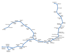
This is a more accurately rendered map of the Piccadilly Line, showing curvature and the relative distance between stops. It illustrates why straight-line maps are more useful when only the sequence of stops is relevant.
A straight-line diagram (abbreviated SLD) is a diagram of a road where the road is shown as a straight line. Such diagrams are usually produced by a highway department, and display features along the road, including bridges and intersecting roads. Rows below the diagram show data about the road, usually including speed limit, number of lanes, bridge numbers, and historical data, among other data. Subway lines also frequently employ straight-line diagrams.
An internal SLD viewing system may also include links to other internal data, including photos or plans. Public SLDs are distributed in formats including PDF and TIFF.
In Australia, "strip maps", which serve a similar function, are distributed by state automobile associations.
See also
References
External links
- Colorado Department of Transportation SLDs
- Florida Department of Transportation SLDs
- New Jersey Department of Transportation SLDs
- North Carolina Department of Transportation SLDs
- Ohio Department of Transportation SLDs
- Pennsylvania Department of Transportation SLDs
- Index of Australian strip maps at the South Australian Royal Automobile Association website
- Sample South Australian RAA strip map from Adelaide to Clare
This article is issued from Wikipedia - version of the 7/8/2015. The text is available under the Creative Commons Attribution/Share Alike but additional terms may apply for the media files.