Stoughton, Massachusetts
| Stoughton, Massachusetts | ||
|---|---|---|
| Town | ||
|
Town center | ||
| ||
| Nickname(s): "Birthplace of American Liberty" | ||
 Stoughton Location in Massachusetts | ||
| Coordinates: 42°07′30″N 71°06′10″W / 42.12500°N 71.10278°WCoordinates: 42°07′30″N 71°06′10″W / 42.12500°N 71.10278°W | ||
| Country | United States | |
| State | Massachusetts | |
| County | Norfolk | |
| Settled | 1713 | |
| Incorporated | 1726 | |
| Government | ||
| • Type | Representative town meeting | |
| Area | ||
| • Total | 16.3 sq mi (42.1 km2) | |
| • Land | 16.0 sq mi (41.5 km2) | |
| • Water | 0.2 sq mi (0.6 km2) | |
| Elevation | 236 ft (72 m) | |
| Population (2010)[1] | ||
| • Total | 26,962 | |
| • Density | 1,685.1/sq mi (649.7/km2) | |
| Time zone | Eastern (UTC-5) | |
| • Summer (DST) | Eastern (UTC-4) | |
| ZIP code | 02072 | |
| Area code(s) | 781 | |
| FIPS code | 25-67945 | |
| GNIS feature ID | 0618330 | |
| Website | http://www.stoughton-ma.gov/ | |


Stoughton /ˈstoʊtᵊn/ (official name: Town of Stoughton) is a town in Norfolk County, Massachusetts, United States. The population was 26,962 at the 2010 census. The town is located approximately 17 miles (27 km) from Boston, 25 miles (40 km) from Providence, and 35 miles (56 km) from Cape Cod.
History
Stoughton was settled in 1713 and officially incorporated in 1726, from the southwestern portion of the large town of Dorchester. At its founding, it included the current towns of Sharon (which separated in 1765), Canton (which separated in 1797) and Avon (which separated in 1888). It was named after William Stoughton, who was the first chief justice of Colonial Courts and the notorious chief justice of the Salem Witch Trials.
The Suffolk Resolves were written in Old Stoughton (current day Milton, Massachusetts) at Doty's Tavern.[2] They are thought to be the basis for the Declaration of Independence. The meeting included the Rev. Samuel Dunbar and Paul Revere; the site was chosen by Samuel Adams and Dr. Joseph Warren.
Originally an agricultural community, Stoughton developed into an important shoemaking center. In 1874, the Stoughton Public Library was established.[3]
The oldest choral society in the United States is located in Stoughton. Founded in 1786 as The Stoughton Musical Society, it is now known as the Old Stoughton Musical Society. It has the oldest constitution of any musical society in the United States, written in 1787, only a few weeks after the United States Constititution. In 1893, this musical society distinguished itself by performing several concerts at the World's Columbian Exposition in Chicago, heard by an audience of several thousand people. In 1986, the musical society celebrated its bicentennial with a series of concerts and special events.[4]
In 1940 artist Jean Watson painted the mural, A Massachusetts Countryside as a project of the WPA. The artwork is currently on display in the attic at the Stoughton Historic Society.
The Save Our Stoughton campaign attracted national attention in the 1980s for their work picketing a local adult book store.[5] Most recently, Stoughton became the first municipality in Massachusetts to declare itself a "No Place for Hate" town.
Stoughton's train station was built in 1888, and is the only one in Massachusetts to house a clock tower. The station is unique in many ways as it was built out of stones from a West Street quarry that belonged to Stoughton resident Myron Gilbert. In 1974 it was listed on the National Register of Historic Places. Over a million dollars was raised to restore the station to its original luster in time for the 100th anniversary. In 2009, however, the MBTA permanently closed the station, which stood at the terminus of the Stoughton Branch of the MBTA's Providence/Stoughton Line. The building still stood but remained closed to the public as of 2015. In 2015, members of Town Meeting voted to purchase the train station from the state. Plans for use of the property are being developed by the Community Preservation Committee.[6]
On August 15, 1908, Stoughton was hit by a moderate earthquake. Although the Blue Hill Meteorological Observatory was affected, the shockwaves did not reach to Boston. On May 9, 2013, a weak, brief, and unexpected tornado touched down in Stoughton, with minor damage occurring. The tornado was ranked as an EF-0 on the Enhanced Fujita scale after the National Weather Service office in Taunton, Massachusetts confirmed this tornado in a damage survey on May 10.[7]
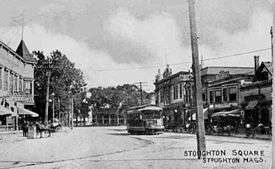
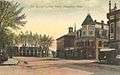 Stoughton Square in 1908
 Public library in 1908
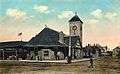 Railway Station c. 1918
 Chicataubut Club in 1911
Geography
According to the United States Census Bureau, the town has a total area of 16.3 square miles (42 km2), of which 16.0 square miles (41 km2) is land and 0.2 square miles (0.52 km2) (2.41%) is water. Stoughton borders Canton to the north, Randolph to the northeast, Avon to the east, Brockton to the southeast, Easton to the south, and Sharon to the west.
Demographics
| Historical population | ||
|---|---|---|
| Year | Pop. | ±% |
| 1850 | 3,494 | — |
| 1860 | 4,830 | +38.2% |
| 1870 | 4,914 | +1.7% |
| 1880 | 4,875 | −0.8% |
| 1890 | 4,852 | −0.5% |
| 1900 | 5,442 | +12.2% |
| 1910 | 6,316 | +16.1% |
| 1920 | 6,865 | +8.7% |
| 1930 | 8,204 | +19.5% |
| 1940 | 8,632 | +5.2% |
| 1950 | 11,146 | +29.1% |
| 1960 | 16,328 | +46.5% |
| 1970 | 23,459 | +43.7% |
| 1980 | 26,710 | +13.9% |
| 1990 | 26,777 | +0.3% |
| 2000 | 27,149 | +1.4% |
| 2010 | 26,962 | −0.7% |
| * = population estimate. Source: United States Census records and Population Estimates Program data.[8][9][10][11][12][13][14][15][16][17] | ||
As of the 2010 Census,[18][19] there were 26,962 people, 10,295 households, and 7,099 families residing in the town. The population density was 1,654.1 inhabitants per square mile (638.7/km2). There were 10,818 housing units at an average density of 663.7 per square mile (256.3/km2). The racial makeup of the town was 80.2% White, 11.1% African American, 0.2% Native American, 2.3% Asian, 1.3% from other races, and 2.6% from two or more races. Hispanic or Latino of any race were 3.2% of the population.
There were 10,295 households out of which 27.9% had children under the age of 18 living with them, 51.5% were married couples living together, 13.1% had a female householder with no husband present, and 31.0% were non-families. 25.6% of all households were made up of individuals and 2.9% had someone living alone who was 65 years of age or older. The average household size was 2.59 and the average family size was 3.13.
In the town the population was spread out with 81.5% of age 16 years and over, 78.7% of age 18 years and over, 75.7% of age 21 years and over, 20.1% of age 62 years and over, and 16.4% of age 65 years and over. The median age was 42.9 years. For every 100 females there were 92.1 males. For every 100 females age 18 and over, there were 88.3 males.
Stoughton has a history of manufacturing and an emerging cluster of regional retail, as well as a substantial base of land zoned for commercial and industrial purposes. The major commercial and industrial areas in town are located adjacent to Route 24 and along routes 138, 139 and 27, but smaller areas are interspersed with residential zones due to the community’s industrial past. The town has significant protected open space resources, including the Bird Street Sanctuary, water department lands, recreational fields and a municipal golf course. Additional privately owned, but not protected, undeveloped lands are an important factor in the character of the community. Stoughton has good access to the regional roadway network, being served by several state routes and 3 interchanges on Route 24. Stoughton also has access to regional transit, being served by bus from Brockton and MBTA Commuter rail at the station in downtown Stoughton.
Government
The Town is governed by a Selectmen-Manager plan with a representative Town meeting. The Board of Selectmen of the town consists of five members, all of whom are elected at large for a term of three years. The Selectmen appoint a Town Manager, who is the chief administrative officer in the executive branch of governmant, and he carries out the policies and plans set forth by the Selectmen. Joe Mokrisky is the current Chairman of the Board of Selectmen.[20] The other Selectmen are David Sousa, TJ Recupero, Robert O'Regan and Robert Cohn.[21] The Town Manager is Michael Hartman.[22] The Stoughton Fire Department provides fire suppression, rescue and EMS services to Stoughton. The Stoughton Fire Department operates out of two stations. Station #1 is located at 30 Freeman Street and Station #2 is located at 1550 Central Street.[23] The Freeman Street Fire Station was opened on June 13, 1927 and has received updates throughout the years and is still open today.[24]
Education
There is one public high school in Stoughton, one public middle school, five elementary schools and several parochial and private schools in nearby towns. Stoughton High School has an award-winning music program, as well as an award-winning newspaper, The SHS Knight, and well-known jazz and marching bands. The town is currently in the planning stages for construction of a new high school.
At the joint meeting of the Board of Selectman, the Stoughton School Committee and the SHS Building Committee on Tuesday November 17, 2015, there was a unanimous vote to endorse the building project by both the Board of Selectman and the Stoughton School Committee.
The Stoughton High School Building Committee voted on Thursday, November 12, 2015 to recommend to the Massachusetts School Building Authority (MSBA) that the Town construct option C2A, to build a new Stoughton High School. The preliminary cost analysis for the total project is estimated to be $126,137,847. The projected state reimbursement is estimated at $54,598,291. The Town’s protected share of the cost is estimated to be $71,539,557.[25]
| School | URL |
|---|---|
| Stoughton High School | http://shs.stoughtonschools.org/ |
| O'Donnell Middle School | http://oms.stoughtonschools.org/ |
| Dawe Elementary | http://dawe.stoughtonschools.org/ |
| Gibbons Elementary | http://gibbons.stoughtonschools.org/ |
| Hansen Elementary | http://hansen.stoughtonschools.org/ |
| Jones Pre-School | http://jones.stoughtonschools.org/ |
| South Elementary | http://south.stoughtonschools.org/ |
| West Elementary | http://west.stoughtonschools.org/ |
Recreation
Several organizations exist in the town for recreation and sports.
The Recreation Department offers a variety of activities throughout the year for both children and adults. The Director is John Denison.[26]
The Stoughton Youth Athletic Club (STOYAC) offers girls softball, boys and girls basketball, football and cheering.[27]
Stoughton Youth Soccer League (SYSL) offers both in-town and travel soccer programs for spring and fall season in divisions ranging from u5 and u6 (co-ed) to u16 and even u18, when there is sufficient participation. The league is based at the Kolz Soccer Complex on West Street, where the league maintains three fields, a concession stand and bathroom facilities. All in-town and home travel games are played at the Kolz Complex. Practices are held there and at other locations around town. SYSL participates in the South Shore Soccer League for travel soccer programs.[28]
Stoughton Youth Baseball is affiliated with Cal Ripken Baseball and Babe Ruth Baseball. It offers skills programs for 5-year old kids; t-ball and instructional leagues for ages 6 and 7; and divisions for 8 and 9 year olds and 10, 11 and 12 year olds.
Stoughton Lacrosse offers programs and leagues for both boys and girls in four divisions, u9, u11, u13 and u15.
Transportation
Stoughton is on an MBTA commuter rail line that runs to South Station in Boston via the Providence/Stoughton Line.The Brockton Area Transit Authority (BAT) provides local bus service.
Annual events
An annual 4th of July fireworks display takes place at the high school. Other Stoughton attractions include local drama groups, summer-time outdoor concerts, and annual parades to honor veterans. Every year on the 4th of July, Stoughton has a parade. Stoughton also has annual parade on Veterans Day. Stoughton has held a Christmas parade on December 18, which started in 1986. The town of Stoughton organizes swimming programs at the Ames Long Pond and provides basketball courts and horseshoe pits at the local parks. The town of Stoughton also offers barbecue spots and picnic areas.
Notable people
- Joe Allen - author, Vietnam: The Last war the U.S. Lost, People wasn't Made to Burn: A True Story of Race, Murder and Justice in Chicago, and The Package King: A Rank and File History of United Parcel Service.
- John Bailey - congressman
- Supply Belcher - composer
- Forrest Bird - aviator, inventor and biomedical engineer
- Doris Holmes Blake - entomologist[29]
- Elmer Hewitt Capen - college president
- Fannie Bishop Capen - missionary
- Bill Chamberlain - Major League Baseball player.
- Thomas H. Collins, U.S. Coast Guard Commandant
- Mo Cowan - U.S. Senator for Massachusetts
- Mary Baker Eddy - religious leader
- Jacob French - composer
- Ed Gill - Major League Baseball player.
- Richard Gridley - soldier and army engineer
- Roger Lee Hall - musicologist and composer
- Jonathan Hausman - Rabbi of Ahavath Torah Congregation and political activist.
- Edwin Arthur Jones - composer
- Kerry Keating - basketball coach
- Ryan LaCasse - football player
- Robert Lanza - Medical Doctor & Researcher
- Ed McGuinness - comic book artist
- Lori McKenna - singer/songwriter
- Shawn Phelan - actor
- Henry L. Pierce - mayor of Boston
- Bertha Reynolds - social worker
- Niccola Sacco - of Sacco & Vanzetti
- Deborah Sampson - female soldier of the Revolution
- Roger Sherman - statesman
- Kenny Wormald - dancer, actor, television personality
References
- ↑ "Population and Housing Occupancy Status: 2010 - State -- County Subdivision, 2010 Census Redistricting Data (Public Law 94-171) Summary File". U.S. Census Bureau. Retrieved 2011-06-26.
- ↑ The Doty Tavern
- ↑ The Trustees of the Stoughton Public Library, stoughtonhistory.com; accessed June 24, 2015.
- ↑ Singing Stoughton, americanmusicpreservation.com; accessed June 24, 2015.
- ↑ Hatch, Richard (June 12, 1983). "FOLLOW-UP ON THE NEWS; Smiting Smut". The New York Times. Retrieved September 7, 2014.
- ↑ Shepard, Cody. "Stoughton voters OK money to buy train station". The Enterprise, Brockton, MA. Retrieved 2016-03-04.
- ↑ "Iowa Environmental Mesonet - National Weather Service Raw Text Product". U.S. National Weather Service. Retrieved May 17, 2013.
- ↑ "TOTAL POPULATION (P1), 2010 Census Summary File 1". American FactFinder, All County Subdivisions within Massachusetts. United States Census Bureau. 2010.
- ↑ "Massachusetts by Place and County Subdivision - GCT-T1. Population Estimates". United States Census Bureau. Retrieved July 12, 2011.
- ↑ "1990 Census of Population, General Population Characteristics: Massachusetts" (PDF). US Census Bureau. December 1990. Table 76: General Characteristics of Persons, Households, and Families: 1990. 1990 CP-1-23. Retrieved July 12, 2011.
- ↑ "1980 Census of the Population, Number of Inhabitants: Massachusetts" (PDF). US Census Bureau. December 1981. Table 4. Populations of County Subdivisions: 1960 to 1980. PC80-1-A23. Retrieved July 12, 2011.
- ↑ "1950 Census of Population" (PDF). Bureau of the Census. 1952. Section 6, Pages 21-10 and 21-11, Massachusetts Table 6. Population of Counties by Minor Civil Divisions: 1930 to 1950. Retrieved July 12, 2011.
- ↑ "1920 Census of Population" (PDF). Bureau of the Census. Number of Inhabitants, by Counties and Minor Civil Divisions. Pages 21-5 through 21-7. Massachusetts Table 2. Population of Counties by Minor Civil Divisions: 1920, 1910, and 1920. Retrieved July 12, 2011.
- ↑ "1890 Census of the Population" (PDF). Department of the Interior, Census Office. Pages 179 through 182. Massachusetts Table 5. Population of States and Territories by Minor Civil Divisions: 1880 and 1890. Retrieved July 12, 2011.
- ↑ "1870 Census of the Population" (PDF). Department of the Interior, Census Office. 1872. Pages 217 through 220. Table IX. Population of Minor Civil Divisions, &c. Massachusetts. Retrieved July 12, 2011.
- ↑ "1860 Census" (PDF). Department of the Interior, Census Office. 1864. Pages 220 through 226. State of Massachusetts Table No. 3. Populations of Cities, Towns, &c. Retrieved July 12, 2011.
- ↑ "1850 Census" (PDF). Department of the Interior, Census Office. 1854. Pages 338 through 393. Populations of Cities, Towns, &c. Retrieved July 12, 2011.
- ↑ "American FactFinder". United States Census Bureau. Retrieved 2008-01-31.
- ↑ http://factfinder2.census.gov/bkmk/table/1.0/en/DEC/10_PL/P1/0600000US2502167945
- ↑ http://stoughton.patch.com/articles/anzivino-elected-chair-of-the-stoughton-board-of-selectmen
- ↑ "Board of Selectmen | Town of Stoughton MA". www.stoughton.org. Retrieved 2016-03-04.
- ↑ "Town Manager | Town of Stoughton MA". www.stoughton.org. Retrieved 2016-03-04.
- ↑ http://www.stoughton-ma.gov/Fire/
- ↑ Stoughton Fire Department First Organized in 1852
- ↑ "High School Building Project | Stoughton Public Schools". www.stoughtonschools.org. Retrieved 2016-03-04.
- ↑ "Recreation Department | Town of Stoughton MA". www.stoughton.org. Retrieved 2016-03-04.
- ↑ "STOYAC". www.stoyac.org. Retrieved 2016-03-04.
- ↑ "Stoughton Youth Soccer League - Powered by LeagueToolbox". stoughtonsoccer.org. Retrieved 2016-03-04.
- ↑ "Record Unit 7310, Blake, Doris Holmes, 1892-1978, Doris Holmes Blake Papers". Smithsonian Archives. Retrieved 29 March 2012.
External links
| Wikimedia Commons has media related to Stoughton, Massachusetts. |
| Wikivoyage has a travel guide for Stoughton, Massachusetts. |
- Town of Stoughton
- Stoughton Public Library
- Stoughton Historical Society - History & Genealogy
- Stoughton Chamber of Commerce
- Singing Stoughton
- Stoughton Public Schools
- Answer Book/Stoughton: Everything you need to know
- Hall, Roger Lee, "World's Columbian Exposition Concerts in 1893", americanmusicpreservation.com
Municipalities and communities of Norfolk County, Massachusetts, United States | ||
|---|---|---|
| Cities | 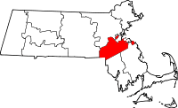 | |
| Towns | ||
| CDPs | ||
| Other village | ||