Stordal
| Stordal kommune | |||
|---|---|---|---|
| Municipality | |||
 | |||
| |||
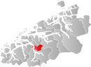 Stordal within Møre og Romsdal | |||
| Coordinates: 62°23′24″N 07°06′38″E / 62.39000°N 7.11056°ECoordinates: 62°23′24″N 07°06′38″E / 62.39000°N 7.11056°E | |||
| Country | Norway | ||
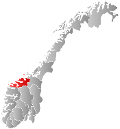
| County | Møre og Romsdal | ||
| District | Sunnmøre | ||
| Administrative centre | Stordal | ||
| Government | |||
| • Mayor (2003) | Charles Tøsse (H) | ||
| Area | |||
| • Total | 247.06 km2 (95.39 sq mi) | ||
| • Land | 243.62 km2 (94.06 sq mi) | ||
| • Water | 3.44 km2 (1.33 sq mi) | ||
| Area rank | 305 in Norway | ||
| Population (2013) | |||
| • Total | 1,052 | ||
| • Rank | 404 in Norway | ||
| • Density | 4.3/km2 (11/sq mi) | ||
| • Change (10 years) | 5.8 % | ||
| Demonym(s) | Stordaling[1] | ||
| Time zone | CET (UTC+1) | ||
| • Summer (DST) | CEST (UTC+2) | ||
| ISO 3166 code | NO-1526 | ||
| Official language form | Nynorsk | ||
| Website |
www | ||
|
| |||

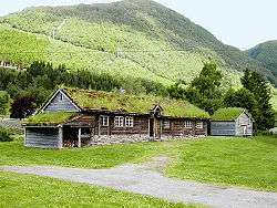
Stordal is a municipality in Møre og Romsdal county, Norway. It is part of the Sunnmøre region. The administrative centre of the municipality is the village of Stordal. The historic farm and museum of Ytste Skotet lies along the Storfjorden in the western part of the municipality. Most of the municipality lies on the eastern side of the fjord.
Stordal has relatively good agricultural land, and the main source of income is livestock. Stordal has also been home to furniture production and continues with the industry today.[2]
General information
Stordal was established as a municipality on 1 January 1892 when it was separated from Stranda Municipality (to the south). The initial population of the municipality was 850. On 1 January 1965, the three municipalities of Ørskog, Skodje, and Stordal were merged into one large Ørskog Municipality. Prior to the merger, there were 1,052 inhabitants in Stordal. The merger, however, was short-lived, and on 1 January 1977 it was reversed and the three municipalities were once again separated.[3]
Name
The Old Norse form of the name was Stóladalr. The first element is the plural genitive case of stóll which means "chair" and the last element is dalr which means "valley" or "dale". Two mountains around the valley have the name Stolen ("the chair"). Before 1918, the name was written Stordalen.[4]
Coat-of-arms
The coat-of-arms is from modern times. They were granted on 30 August 1991. The arms show a gold pale on a blue background. The pale symbolises the forestry and furniture manufacturing in the municipality, which traditionally uses a dove-tail system to join two pieces of wood. The same symbol also indicates the strong community feeling in the villages.[5]
Churches
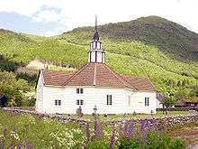
The Church of Norway has one parish with one church, within the municipality of Stordal. There is also the old church, Rosekyrkja, which is now a museum. It is part of the Austre Sunnmøre deanery in the Diocese of Møre.
| Parish (Sokn) | Church Name | Location of the Church | Year Built |
|---|---|---|---|
| Stordal | Stordal Church | Stordal | 1907 |
| Old Stordal Church (Rosekyrkja)* | Stordal | 1789 | |
| *The Rosekyrkja has been a museum church since 1908. | |||
Geography
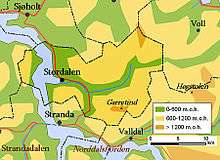
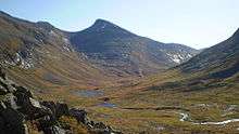
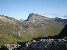
Stordal municipality is located along the inner Storfjorden in Sunnmøre. The majority of the municipality lies east of the fjord, while a small uninhabited mountainous area on the west side of the fjord is also part of Stordal. Ytste Skotet is a preserved historic farm/museum that is located on the steep mountainsides on the west side of the fjord. Most of the municipality surrounds the Stordalen valley on the east side of the fjord.[2]
Ørskog Municipality and Vestnes Municipality lie to the north of Stordal, Rauma Municipality lies to the east, Norddal Municipality and Stranda Municipality lie to the south, and Sykkylven Municipality lies to the west. The municipality is fairly isolated, with only two road connections to the outside world. Norwegian County Road 650 runs through the municipality from north to south, connecting it to Ørskog Municipality to the north and to Stranda Municipality to the south. Due to the mountainous landscape, the highway goes through the Dyrkorn Tunnel and Stordal Tunnel in the northern part of the municipality. The two tunnels are separated by the small village of Dyrkorn.[2]
Settlers in Iceland
Some people from Stordal settled in Iceland and used Stordal as their last name. The Stordal family is quite known in Iceland but the siblings Sigurður Kristinn Stórdal and Lovísa Stórdal are the most known well-known Stordals currently alive. They are descendants of Egill "Sterki" Stórdal and Ásgerður "Fagra" Stórdal. Egill and his wife became farmers in Stordal which is now known as Skorradalur in Borgarfjörður, Iceland.
References
- ↑ "Navn på steder og personer: Innbyggjarnamn" (in Norwegian). Språkrådet. Retrieved 2015-12-01.
- 1 2 3 Store norske leksikon. "Stordal" (in Norwegian). Retrieved 2013-06-21.
- ↑ Jukvam, Dag (1999). "Historisk oversikt over endringer i kommune- og fylkesinndelingen" (PDF) (in Norwegian). Statistisk sentralbyrå.
- ↑ Rygh, Oluf (1908). Norske gaardnavne: Romsdals amt (in Norwegian) (13 ed.). Kristiania, Norge: W. C. Fabritius & sønners bogtrikkeri. p. 134.
- ↑ Norske Kommunevåpen (1990). "Nye kommunevåbener i Norden". Retrieved 25 October 2008.
External links
 Media related to Stordal at Wikimedia Commons
 Møre og Romsdal travel guide from Wikivoyage