Stony Brook (Boston)
Stony Brook was formerly a major watercourse in the city of Boston, USA. It originates at Turtle Pond in the Stony Brook Reservation; it flows through Hyde Park, Roslindale, Jamaica Plain, and Roxbury. It formerly emptied into the Back Bay, a tidal part of the Charles River.
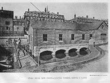
In the 18th century, water-powered industry grew up along it (including Pierpoint('s) Mill[1]) and it served as the sewer (excluding human waste) for the neighborhoods it ran through.
The Boston and Providence Railroad (now the Providence/Stoughton Line) was built along the valley of Stony Brook in 1834.
In the 19th century, many breweries and other industries grew up along Stony Brook.[2]
In the late 19th century, various parts of Stony Brook were converted into underground culverts or sewers. In around 1882, the Back Bay Fens were dredged to convert them into a holding basin for storm overflow from Stony Brook, following Olmsted's plan, and at around the same time its waters were diverted into an intercepting sewer near the current Ruggles Station.
Notes
- ↑ "Boston, its environs and harbour, with the rebels works raised against that town in 1775, from the observations of Lieut. Page of His Majesty's Corps of Engineers, and from those of other gentlemen"
- ↑ "Stony Brook", Heart of the City Project, Center for Urban and Regional Policy, Northeastern University, a database of greenspaces in Boston: http://ksgaccman.harvard.edu/hotc/DisplayPlace.asp?id=11378
References
- "Annual Report of the Street Department", February 1, 1892 in Documents of the City of Boston for the Year 1892, 2:110 at Google Books
- Alex Krieger, David A. Cobb, and Amy Turner, Mapping Boston, p. 131ff
- "A Sewer Runs Through It", The City Record and Boston News-Letter, blog page
- "The Stony Brook During a Flood, c. 1890", The City Record and Boston News-Letter, blog page
- Edwin Munroe Bacon, Walks and rides in the country round about Boston full text
External links
- W.H. Marx, "The Saga of Stony Brook", Jamaica Plain Historical Society http://www.jphs.org/locales/2004/1/5/the-saga-of-stony-brook.html
- A blog devoted to Stony Brook: http://stonybrookinboston.blogspot.com/
Coordinates: 42°20′20″N 71°05′10″W / 42.339°N 71.086°W