Stonington Island
Stonington Island is a rocky island lying 1.8 km (1.1 mi) north-east of Neny Island in the eastern part of Marguerite Bay, off the west coast of Graham Land, Antarctica. Stonington Island is 0.75 km (0.47 mi) long from north-west to south-east and 0.37 km (0.23 mi) wide and was formerly connected by a drifted snow slope to Northeast Glacier on the mainland.
History
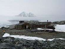
Stonington Island was chosen as the site for the East Base of the United States Antarctic Service (USAS) Expedition (1939–1941) and named after Stonington, Connecticut, home port of the sloop Hero in which Captain Nathaniel Palmer sighted the Antarctic continent in 1820.[1] The base was also home to the British Antarctic Survey (BAS)'s Base E, the Ronne Antarctic Research Expedition, and was the base of operations for many historic Antarctic Peninsula surveying missions in the 1940s. Base E was occupied until February 1975, and was cleaned up and repaired in 1992.[2] The huts are protected under the Antarctic Treaty.[3]
Historic sites
A protected area on the island comprises the buildings and artefacts at East Base (with their immediate environs) that were erected and used during the two US wintering expeditions. The size of the area is about 1000 m north-south (from the beach to Northeast Glacier adjacent to Back Bay) and 500 m east-west. It has been designated a Historic Site or Monument (HSM 55), following a proposal by the USA to the Antarctic Treaty Consultative Meeting (ATCM). The British Base E research station is also considered to be of historical importance in relating to both the early period of exploration and the later BAS history of the 1960s and 1970s, and has been similarly designated a Historic Site or Monument (HSM 64), following a proposal by the United Kingdom to the ATCM.[4]
Environment
Climate
| Climate data for Stonington Islands | |||||||||||||
|---|---|---|---|---|---|---|---|---|---|---|---|---|---|
| Month | Jan | Feb | Mar | Apr | May | Jun | Jul | Aug | Sep | Oct | Nov | Dec | Year |
| Record high °C (°F) | 6 (43) |
7 (45) |
8 (46) |
7 (45) |
4 (39) |
7 (45) |
4 (39) |
4 (39) |
5 (41) |
6 (43) |
8 (46) |
7 (45) |
8 (46) |
| Average high °C (°F) | 3 (37) |
1 (34) |
−2 (28) |
−4 (25) |
−6 (21) |
−8 (18) |
−8 (18) |
−9 (16) |
−8 (18) |
−4 (25) |
−3 (27) |
2 (36) |
−3.8 (25.3) |
| Average low °C (°F) | −3 (27) |
−4 (25) |
−8 (18) |
−10 (14) |
−14 (7) |
−17 (1) |
−18 (0) |
−19 (−2) |
−16 (3) |
−13 (9) |
−9 (16) |
−3 (27) |
−11.2 (12.1) |
| Record low °C (°F) | −12 (10) |
−11 (12) |
−35 (−31) |
−27 (−17) |
−36 (−33) |
−37 (−35) |
−36 (−33) |
−37 (−35) |
−39 (−38) |
−29 (−20) |
−20 (−4) |
−13 (9) |
−39 (−38) |
| Average precipitation mm (inches) | 10 (0.39) |
15 (0.59) |
25 (0.98) |
25 (0.98) |
43 (1.69) |
28 (1.1) |
33 (1.3) |
25 (0.98) |
41 (1.61) |
43 (1.69) |
23 (0.91) |
5 (0.2) |
316 (12.42) |
| Average precipitation days | 3 | 4 | 7 | 7 | 9 | 6 | 7 | 7 | 7 | 8 | 5 | 1 | 71 |
| Source: | |||||||||||||
Important Bird Area
A circular, 500 ha site on the island has been designated an Important Bird Area (IBA) by BirdLife International because it supports a breeding colony of about 135 pairs of imperial shags. Other birds breeding at the site include south polar skuas and Antarctic terns.[5]
See also
References
- ↑ Parfit, Michael; Robb Kendrick (March 1993). "Reclaiming a Lost Antarctic Base". National Geographic. 183 (3): 110–126.
- ↑ "Stonington Island - Antarctic Historic Site and Monument". British Antarctic Survey, Natural Environmental Research Council. Retrieved 2009-05-31.
- ↑ Stonehouse, Bernard (2002). Encyclopedia of Antarctica and the Southern Oceans. John Wiley and Sons. ISBN 0-471-98665-8.
- ↑ "List of Historic Sites and Monuments approved by the ATCM (2012)" (PDF). Antarctic Treaty Secretariat. 2012. Retrieved 2014-01-03.
- ↑ "Stonington Island". BirdLife data zone: Important Bird Areas. BirdLife International. 2013. Retrieved 2013-01-20.
External links
Coordinates: 68°11′S 67°00′W / 68.183°S 67.000°W