Stoke Poges
| Stoke Poges | |
 St. Giles' parish church |
|
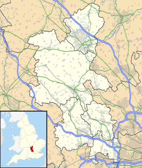 Stoke Poges |
|
| Area | 10.09 km2 (3.90 sq mi) |
|---|---|
| Population | 4,752 (2011 census)[1] |
| – density | 471/km2 (1,220/sq mi) |
| OS grid reference | SU9884 |
| Civil parish | Stoke Poges |
| District | South Bucks |
| Shire county | Buckinghamshire |
| Region | South East |
| Country | England |
| Sovereign state | United Kingdom |
| Post town | Slough |
| Postcode district | SL2 |
| Dialling code | 01753 |
| Police | Thames Valley |
| Fire | Buckinghamshire |
| Ambulance | South Central |
| EU Parliament | South East England |
| UK Parliament | Beaconsfield |
| Website | Stoke Poges Buckinghamshire |
|
|
Coordinates: 51°32′46″N 0°35′02″W / 51.546°N 0.584°W
Stoke Poges is a green-buffered scattered village and civil parish in the South Bucks district of Buckinghamshire, England. It is centred approximately three miles north of Slough (historically Upton-cum-Chalvey), its post town, and a mile east of Farnham Common.
Origin of the name
In the name Stoke Poges, stoke means "stockaded (place)" that is staked with more than just boundary-marking stakes. In the Domesday Book of 1086, the village was recorded as Stoche. William Fitz-Ansculf, who held the manor in 1086 (in the grounds of which the Norman parish church was built), later became known as William Stoches or William of Stoke. Two hundred years after William, Amicia of Stoke, heiress to the manor, married Robert Pogeys, Knight of the Shire, and the village eventually became known as Stoke Poges. The spelling appearing as "Stoke Pocheys", if applicable to this village, may suggest the pronunciation of the second part to have a slightly more open "o" sound compared with the word "Stoke".[2]
Stoke Poges manor house
A manor house at Stoke Poges was built before the Norman Conquest and was mentioned in the 1086 Domesday Book. In 1555 the then-owner, Francis Hastings, 2nd Earl of Huntingdon, pulled down much of the existing fortified house. He replaced it with a large Tudor brick-built house, with numerous chimneys and gables. In 1599 it was acquired by Sir Edward Coke, who is said to have entertained Queen Elizabeth I there in 1601.
A few decades later, the married lady of the manor, Lady Purbeck, had a love affair with Robert Howard, a member of parliament. The affair's discovery was received as a scandal upon the three people involved, and in 1635 Lady Purbeck was imprisoned for adultery. She escaped from prison to France, but later returned to Stoke Poges, where she died in 1645.
King Charles I was imprisoned at the manor house in 1647 before his execution.
Later the manor came into the possession of Thomas Penn, a son of William Penn who founded Pennsylvania and was its first proprietor. Thomas Penn held three-fourths of the proprietorship. The manor property remained in his family for at least two generations, as his son John Penn "of Stoke" also lived there.
Thomas Gray's 1750 poem, "A Long Story," describes the house and its occupants.[3] Sir Edwin Henry Landseer was a frequent visitor to the house and rented it as a studio for some time. His most famous painting, The Monarch of the Glen (1851), is said to have been created at Stoke Poges, with the deer in the park used as models.
Education
The village has a primary school, The Stoke Poges School, which admits children residing in the catchment area aged 5–11.[4]
St Giles' church
Gray's "Elegy Written in a Country Churchyard" is believed to have been written in the churchyard of the Church of England parish church of Saint Giles in Stoke Poges, also known as the Stoke Poges Church. Other churches have claimed the honour, including St Laurence's in Upton and St. Mary's in Everdon, Northamptonshire.

Gray is buried at St Giles'. John Penn "of Stoke" had a large monument built, displaying verses from the Elegy, nearby.
The Georgian rectory was built by Thomas Penn of Stoke Park in 1765. It is now a private residence called Elegy House.
In film, fiction and the media
- Stoke Poges is mentioned in the book Brave New World by Aldous Huxley, where it is the location of a frequently-visited golf course.
- 1990 'Inspector Lynley' crime novel Well-Schooled in Murder by Elizabeth George, and its television adaptation, are set in Stoke Poges.
- The golf course at Stoke Park was the setting of a golf match in the James Bond film Goldfinger (1964), played between the principal characters.[5]
- Stoke Park is also featured in the films Layer Cake, Wimbledon, Bride and Prejudice, and Bridget Jones' Diary.
- In the film I Could Go on Singing (1963), Judy Garland's character visits St. Giles' parish church with her son.
- The 1981 James Bond film For Your Eyes Only filmed its opening sequence, when Bond visits his wife's grave, in the graveyard at St Giles Church.[6]
- Part of the 2007 series Jekyll was filmed on the boardwalk and surrounding area.
- In Nick Hancock's Football Nightmares Nick Hancock is trying to hitchhike to the Victoria Ground in Stoke-on-Trent, but keeps getting dropped off in, or just outside, Stoke Poges.
Notable natives and residents
- Thomas Penn, son of William Penn and proprietor of Pennsylvania, with three-fourths holding.
- Jacques Laffite, the French Formula One racing driver who won six Grands Prix for Ligier during the late 1970s and early 1980s, lived in Stoke Poges during some of his racing career.
- Sir Henry Martin (Marten) (c.1562–1641), DCL, Fellow of New College, King's Advocate for James I, 1609, and Judge of Admiralty Court (1617–1641) is reported to have been born at Stokes Poges.[7]
Demography
| Stoke Poges compared | |||
|---|---|---|---|
| 2001 UK Census | Stoke Poges ward | South Bucks borough | England |
| Population | 4,839 | 61,945 | 49,138,831 |
| Foreign born | 11.9% | 12.2% | 9.2% |
| White | 93.3% | 93.4% | 90.9% |
| Asian | 4.8% | 4.5% | 4.6% |
| Black | 0.3% | 0.4% | 2.3% |
| Christian | 76.5% | 75.6% | 71.7% |
| Muslim | 1.1% | 1.1% | 3.1% |
| Hindu | 0.7% | 1.2% | 1.1% |
| No religion | 10.6% | 12.5% | 14.6% |
| Unemployed | 1.8% | 1.9% | 3.3% |
| Retired | 16.8% | 14.8% | 13.5% |
At the 2001 UK census, the Stoke Poges electoral ward had a population of 4,839. The ethnicity was 93.3% white, 1.3% mixed race, 4.8% Asian, 0.3% black and 0.3% other. The place of birth of residents was 88.1% United Kingdom, 1.6% Republic of Ireland, 2.5% other Western European countries, and 7.8% elsewhere. Religion was recorded as 76.5% Christian, 0.2% Buddhist, 0.7% Hindu, 2.7% Sikh, 0.5% Jewish, and 1.1% Muslim. 10.6% were recorded as having no religion, 0.2% had an alternative religion and 7.6% did not state their religion.[8]
The economic activity of residents aged 16–74 was 40.8% in full-time employment, 11.6% in part-time employment, 12.6% self-employed, 1.8% unemployed, 1.5% students with jobs, 3.1% students without jobs, 16.8% retired, 6.7% looking after home or family, 2.5% permanently sick or disabled and 2.5% economically inactive for other reasons. The industry of employment of residents was 15.4% retail, 13.4% manufacturing, 6.9% construction, 21.1% real estate, 9.2% health and social work, 7.3% education, 8.8% transport and communications, 3.5% public administration, 3.4% hotels and restaurants, 2.8% finance, 0.8% agriculture and 7.4% other. Compared with national figures, the ward had a relatively high proportion of workers in real estate, transport and communications. According to Office for National Statistics estimates, during the period of April 2001 to March 2002 the average gross weekly income of households was £870, compared with an average of £660 in South East England. Of the ward's residents aged 16–74, 28.4% had a higher education qualification or the equivalent, compared with 19.9% nationwide.[8]
In 2011, The Daily Telegraph deemed Stoke Poges as Britain's eighth richest village and the third richest village in Buckinghamshire.[9]
| Output area | Homes owned outright | Owned with a loan | Socially rented | Privately rented | Other | km² roads | km² water | km² domestic gardens | km² domestic buildings | km² non-domestic buildings | Usual residents | km² |
|---|---|---|---|---|---|---|---|---|---|---|---|---|
| Civil parish | 727 | 717 | 183 | 159 | 28 | 0.397 | 0.076 | 1.422 | 0.176 | 0.057 | 4752 | 10.09 |
Geography
Hamlets within Stoke Poges parish include:
- Hollybush Hill
- Stoke Green
References
- 1 2 Key Statistics: Dwellings; Quick Statistics: Population Density; Physical Environment: Land Use Survey 2005
- ↑ Plea Rolls of the Court of Common Pleas; National Archives; CP40/647; http://aalt.law.uh.edu/AALT1/H6/CP40no647/aCP40no647fronts/IMG_0029.htm; second entry, with "London" in the margin, & with defendants Thomas Clerk, William Adam, John Lambard & John Spykernell of Stoke Pocheys.
- ↑ "A Long Story". Thomas Gray Archive. December 2012. Retrieved 1 March 2013.
- ↑ "The School". The Stoke Poges School. Retrieved 17 March 2015.
- ↑ "Goldfinger film locations (1964)".
- ↑ "For Your Eyes Only film locations".
- ↑ Brief Lives John Aubrey Clarendon Press, 1898 – Great Britain
- 1 2 "Neighbourhood Statistics". Statistics.gov.uk. Retrieved 20 April 2008.
- ↑ "Britain's richest villages". The Daily Telegraph. Retrieved 3 April 2011.
External links
| Wikimedia Commons has media related to Stoke Poges. |
 "Stoke Poges". Encyclopædia Britannica. 25 (11th ed.). 1911.
- Stoke Poges Parish Council
- Stoke Poges Village Centre
- Stoke Park Club Official Website
- Stoke Poges Parish Church of St Andrew and St Giles
South Bucks District | ||
|---|---|---|
| Towns (component areas and hamlets) | 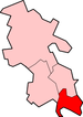 | |
| Other civil parishes (component villages and hamlets) | ||
| Former districts and boroughs | ||
| Former constituencies | ||