Stocking Pelham
| Stocking Pelham | |
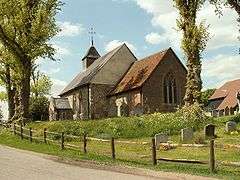 St. Mary's Church, Stocking Pelham |
|
 Stocking Pelham |
|
| Population | 163 (2011 Census)[1] |
|---|---|
| OS grid reference | TL4529 |
| District | East Hertfordshire |
| Shire county | Hertfordshire |
| Region | East |
| Country | England |
| Sovereign state | United Kingdom |
| Post town | BUNTINGFORD |
| Postcode district | SG9 |
| Dialling code | 01279 |
| Police | Hertfordshire |
| Fire | Hertfordshire |
| Ambulance | East of England |
| EU Parliament | East of England |
|
|
Coordinates: 51°56′31″N 0°06′43″E / 51.942°N 0.112°E


Stocking Pelham is a village and civil parish in the East Hertfordshire district of Hertfordshire, England. It is located on the border with Essex, around 6 miles (10 km) east of Buntingford.The village is one of the three Pelhams, along with the nearby Brent Pelham and Furneux Pelham. Stocking Pelham was described to have had a population of 163 according to the 2001 census,[2] remaining at 163 in the 2011 Census. [1] Stocking Pelham is home to St. Mary's Church (pictured right) practicing Christianity in the Church of England Diocese of St Albans.[3] The aerial view of Stocking Pelham shows that the settlements are sparsely positioned from one another.
Close by the village is a major electrical substation of the National Grid.
Population
Stocking Pelham had a population of 163 according to the 2001 census[2] and the total population was also 163 in 2011 according to the 2011 census.[4] This is illustrated in the graph entitled 'The Population of Stocking Pelham from 2001 to 2011' on the bottom right panel of this page, the straight horizontal line shows that the population was the same after ten years. Historically speaking, much of Stoking Pelham was rather heavily dependent on agriculture for income and in some cases this is still apparent, considering the nature of the environment this may explain why there are now many retired citizens residing there.[5]
History
St. Mary's Church has a tiled chancel roof and a nave which date back to around 1360. Either late 14th or early 15th century a narrow isle was added which required a widened nave. The eastern wall and southern wall of the chancel were re-built in brick in the 19th century.[6]
In the 1870s the location of Stocking Pelham was described as
"a parish in Bishops-Stortford district, Herts; adjacent to Essex, 5¼ miles N W of Stanstead r. station, and 6 E of Buntingford."[7]
The 1881 Occupational Structure of Stoking Pelham is illustrated in a pie chart below. The chart shows that 46% of the residents at the time were employed in the agricultural sector, hence there was a clear reliance on agricultural labour. In fact, Stocking Pelham almost completely dependent on primary sector labour with a small fraction of 5% working in 'Professional Labour'.[8] Although, the 2011 Occupational Structure of Stocking Pelham also depicted in a pie chart below in accordance to Neighbourhood Statistics shows that since the 19th century Stocking Pelham has since broke from its dependence on primary sector labour. In comparison to the 1881 Occupational Structure citizens are no longer heavily dependent on agricultural labour as a means of income and are now habouring a more diversely skilled workforce, 26% were employed in professional occupations and 19.5% were employed as managers, directors and senior officials. The remaining 54.5% of the workforce were reported to be working within the tertiary and secondary sectors also.[9]
See also
.jpg)

References
- 1 2 "Civil Parish population 2011". Neighbourhood Statistics. Office for National Statistics. Retrieved 2 November 2016.
- 1 2 "Stocking Pelham: Key Figures for 2001 Census: Key Statistics". Neighbourhood Statistics. Office for National Statistics. Retrieved 4 February 2016.
- ↑ "A Church Near You: St. Mary, Stocking Pelham". achurchnearyou. Archbishop's Council. Retrieved 18 April 2016.
- ↑ "Stocking Pelham: Key Figures for 2011 Census: Key Statistics". Neighbourhood Statistics. Office for National Statistics. Retrieved 11 April 2016.
- ↑ "St Mary The Virgin, Stocking Pelham". St Andrews Much Hadham. St Andrew's Much Hadham. Retrieved 23 April 2016.
- ↑ "An Inventory of the Historical Monuments in Hertforshire". British History Online. His Majesty's Stationery Office. 1910. Retrieved 22 April 2016.
- ↑ Wilson, John Marius (1870–72). Imperial Gazetter of England and Wales. Edinburgh: A. Fullerton & Co.
- ↑ "1881 Census of England and Wales, Tables: Ages, Condition as to Marriage, Occupations and Birthplaces of people, Table 10: " Occupations of Males and Females in the Division and its Registration Counties". Vision of Britain. Retrieved 21 April 2016.
- ↑ "Stocking Pelham: Occupation, 2011". Neighbourhood Statistics. Neighbourhood Statistics. 2011. Retrieved 23 April 2016.
External links
- Photograph of the Cock, 1996
 Media related to Stocking Pelham at Wikimedia Commons