Stickney Township, Cook County, Illinois
| Stickney Township | |
|---|---|
| Township | |
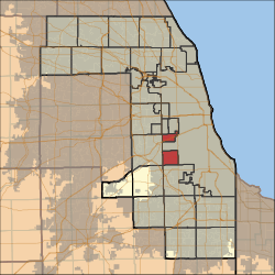 Location in Cook County | |
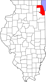 Cook County's location in Illinois | |
| Coordinates: 41°46′24″N 87°46′07″W / 41.77333°N 87.76861°WCoordinates: 41°46′24″N 87°46′07″W / 41.77333°N 87.76861°W | |
| Country | United States |
| State | Illinois |
| County | Cook |
| Established | 1901 |
| Area | |
| • Total | 12.69 sq mi (32.87 km2) |
| • Land | 12.5 sq mi (32.4 km2) |
| • Water | 0.18 sq mi (0.47 km2) 1.43% |
| Elevation | 614 ft (187 m) |
| Population (2010) | |
| • Total | 40,772 |
| • Density | 3,259/sq mi (1,258.4/km2) |
| Time zone | CST (UTC-6) |
| • Summer (DST) | CDT (UTC-5) |
| ZIP codes | 60402, 60455, 60459 60629, 60638 60804 |
| GNIS feature ID | 0429798 |
| Website |
www |
Stickney Township is one of 29 townships in Cook County, Illinois, USA. As of the 2010 census, its population was 40,772,[1] with approximately 71% of that total living in the city of Burbank (pop. 28,925).
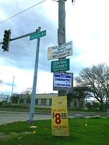
Township offices are located at 5635 W. State Road in Burbank. Other municipalities in the township include Stickney (pop. 6,786) and Forest View (pop. 698), and the largely industrial eastern half of Bedford Park, as well as some small portions of Bridgeview. The unincorporated communities of Central Stickney and Nottingham Park are also within the township. Stickney Township's approximate borders are Pershing Road (39th Street) on the north, Cicero Avenue on the east, 87th Street on the south, and Harlem Avenue on the west, excepting those areas in the Chicago communities of Garfield Ridge and Clearing (which include Chicago Midway International Airport), but also including the area between Laramie and Cicero Avenues as far north as 35th Street.
Geography
According to the United States Census Bureau, Stickney Township covers an area of 12.69 square miles (32.9 km2); of this, 12.51 square miles (32.4 km2) (98.57 percent) is land and 0.18 square miles (0.47 km2) (1.43 percent) is water.
Borders
Stickney Township is bordered on the north by Berwyn and Cicero townships, on the west by Lyons Township, and on the south by Worth Township. On the east, it is bordered by the Chicago communities of West Lawn and Ashburn. Stickney Township was originally part of Lake Township, until much of its area was annexed by the city of Chicago in 1889; afterward, the remaining area became part of Lyons Township until 1901.
Cities, towns, villages
- Bedford Park (east three-quarters)
- Bridgeview
- Burbank
- Forest View (vast majority)
- Stickney
The southwest edge of the city of Chicago is within this township geographically but is a separate entity.
Adjacent townships
- Berwyn Township (north)
- Cicero Township (north)
- Worth Township (south)
- Palos Township (southwest)
- Lyons Township (west)
- Riverside Township (northwest)
Cemeteries
The township contains Mount Auburn Memorial Cemetery.
Major highways
Airports and landing strips
- Rose Packing Company Heliport
Politics
Since 1973, the township supervisor has been Louis Viverito of Burbank; he has also served as the township's Cook County Democratic committeeman from 1969 to February 2007, and as an Illinois state senator from 1995 to 2011.
Political districts
- Illinois' 3rd congressional district
- State House District 21
- State House District 22
- State House District 23
- State House District 31
- State Senate District 11
- State Senate District 12
- State Senate District 16
References
- "Stickney Township, Cook County, Illinois". Geographic Names Information System. United States Geological Survey. Retrieved 2010-01-10.
- United States Census Bureau 2007 TIGER/Line Shapefiles
- United States National Atlas
- ↑ "Geographic Identifiers: 2010 Demographic Profile Data (DP-1): Stickney township, Cook County, Illinois". U.S. Census Bureau, American Factfinder. Retrieved March 21, 2013.
External links
- Stickney Township official website
- City-Data.com
- Illinois State Archives
- Township Officials of Illinois
- "2000 U.S. Census: Profile of General Demographic Characteristics" (PDF). (39.1 KiB)
- South Stickney Sanitary District - township history
- Stickney Public Health District
- Cook County official site