Steynsburg
| Steynsburg | |
|---|---|
|
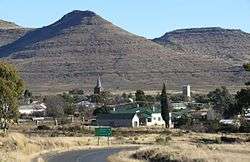
View of Steynsburg | |
 Steynsburg  Steynsburg  Steynsburg
| |
| Coordinates: 31°17′47″S 25°49′22″E / 31.29639°S 25.82278°ECoordinates: 31°17′47″S 25°49′22″E / 31.29639°S 25.82278°E | |
| Country | South Africa |
| Province | Eastern Cape |
| District | Joe Gqabi |
| Municipality | Gariep |
| Established | 1872 |
| Government | |
| • Type | Local Municipality |
| • Councillor | (ANC) |
| Area[1] | |
| • Total | 17.4 km2 (6.7 sq mi) |
| Elevation | 1,450 m (4,760 ft) |
| Population (2011)[1] | |
| • Total | 7,212 |
| • Density | 410/km2 (1,100/sq mi) |
| Racial makeup (2011)[1] | |
| • Black African | 80.5% |
| • Coloured | 14.7% |
| • Indian/Asian | 0.2% |
| • White | 3.9% |
| • Other | 0.6% |
| First languages (2011)[1] | |
| • Xhosa | 74.4% |
| • Afrikaans | 20.5% |
| • English | 1.8% |
| • Sotho | 1.0% |
| • Other | 2.4% |
| Postal code (street) | 5920 |
| PO box | 5920 |
| Area code | 048 |
Steynsburg is a town of the Gariep Local Municipality in Joe Gqabi District Municipality of the Eastern Cape province of South Africa. Steynsburg is located on the intersection of the R56 and R390.
The town lies 64 km south-west of Burgersdorp and 48 km north of Hofmeyr. It developed around the Reformed Church established in 1872 and has been administered by a village management board since 1874. Steynsburg is named after Douwe Gerbrandt Steyn, grandfather of President Paul Kruger.[2]
Steynsburg has a well-established provincial hospital.[3]
Notable Citizens
References
- 1 2 3 4 Sum of the Main Places Khayamnandi and Steynsburg from Census 2011.
- ↑ "Dictionary of Southern African Place Names (Public Domain)". Human Science Research Council. p. 417.
- ↑ Eastern Cape Department of Health website
External links
![]() Media related to Steynsburg at Wikimedia Commons
Media related to Steynsburg at Wikimedia Commons
 |
Norvalspont Colesberg |
Gariep Dam Venterstad 64 km |
Aliwal North Burgersdorp 64 km |
|
| Middelburg 90 km | |
Molteno 53 km | ||
| ||||
| | ||||
| Cradock | Hofmeyr 48 km | Queenstown |
Municipalities and communities of Joe Gqabi District Municipality, Eastern Cape | ||
|---|---|---|
District seat: Barkly East | ||
| Elundini | .svg.png) | |
| Senqu | ||
| Maletswai | ||
| Gariep | ||
This article is issued from Wikipedia - version of the 8/18/2016. The text is available under the Creative Commons Attribution/Share Alike but additional terms may apply for the media files.