Steven's Eyot

Steven's Eyot (or Steven's Ait) is a narrow ait (island) in the River Thames in the Royal Borough of Kingston upon Thames, London, England, on the non-tidal reach above Teddington Lock.
Geography
Steven's Eyot is 660 m (720 yd) below Kingston Railway Bridge and its southern tip is opposite the north of the boating area of Kingston Rowing Club shared by Tiffin School Boat Club on the east, Surrey, bank in Canbury Gardens.[1] On the west, Middlesex, bank are the houses, meadows, apartments and three boathouses of Broom Park, Teddington. A very much smaller eyot to its north leads the Ordnance Survey to record the island as a pair, "Steven's Eyots".[2]
History
The Ordnance Survey map of 1875 shows that the eyot previously comprised four islets and on the map of 1896 it is marked as Tathim's island.[3] The present name derives from a boatman who lived in a nearby cottage situated in what became Canbury Gardens.[4] The present name was in use on the 1913 Ordnance Survey map. The island now forms part of a conservation area.[5]
Management
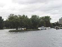
River traffic is directed to the Middlesex side because of posts and mooring on the Surrey side (east here).[6] The island is the base of the Small Boat Club (SBC), a not-for-profit motorboats club formed in 1953 run by the members for the members, using its carved out basin in the north and reinforced moorings on all sides.[2] The SBC has leased the island from the Thames Conservancy (now the Environment Agency) since 1960, giving only Small Boat Club members the right to permanent mooring on the island. Kingston Council granted the SBC permission to erect and have exclusive rights a jetty on the Surrey bank towpath, operational since May 1984.[7]
See also
Notes and References
- ↑ "Grid reference Finder measurement tools". Retrieved 21 November 2012.
- 1 2 The National Heritage List for England - Map Search (Map). Ordnance Survey. Retrieved 21 November 2012. courtesy of English Heritage
- ↑ London (Map). 1 : 10,560. Ordnance Survey. 1896. Retrieved 22 July 2013.
- ↑ Samson, June (11 June 2013). "Bringing a panoramic treasure of River Thames back to life". This is Local London. Retrieved 22 July 2013.
- ↑ CAP Studios (22 November 2002). "Conservation Area Appraisal - Canbury Gardens - for Kingston Upon Thames Borough Council" (PDF). Royal Borough of Kingston upon Thames.
- ↑ "Environment Agency". Retrieved 21 November 2012.
- ↑ "Celebrating its Diamond Jubilee 60th Year!". The Small Boats Club. Retrieved 22 July 2013.
| Next island upstream | River Thames | Next island downstream |
| Raven's Ait | Steven's Eyot | Trowlock Island |
Coordinates: 51°25′12″N 00°18′22″W / 51.42000°N 0.30611°W