Steinkjer (town)
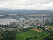

Steinkjer is a town in and the municipal center of Steinkjer, Norway. As of 2014, it has a population of 12,224 and covers an area of 8.76 square kilometers (3.38 sq mi).[1] Steinkjer is also the administrative center of the county of Nord-Trøndelag. The town is located at the end of Trondheimsfjord at the mouth of the river of Steinkjerelva. In the eastern part of the town, the river of Figgja also flows into the fjord. The town is split in two by Steinkjerelva, creating the two traditional neighborhoods of Nordsia and Sørsia.
From the creation of municipalities in 1837, Steinkjer was part of Stod. Township was awarded in 1857, and from 23 January 1858, it was separated from Stod to form a municipality of its own. The initial population of Steinkjer was 1,150. On 1 January 1964, a major municipal merger took place, as the municipalities of Beitstad, Egge, Kvam, Ogndal, Sparbu, and Stod were all merged with the town of Steinkjer (population: 4,325) to form a new, larger municipality of Steinkjer.[2] Both the European Road E6 and the Nordland Line run through the town, the latter serving the city at Steinkjer Station.
References
| Wikimedia Commons has media related to Steinkjer (town). |
- ↑ "Tettsteder. Folkemengde og areal, etter kommune. 1.januar 2011." (in Norwegian). Statistics Norway. Retrieved 4 February 2012.
- ↑ Jukvam, Dag (1999). "Historisk oversikt over endringer i kommune- og fylkesinndelingen" (PDF) (in Norwegian). Statistics Norway.
As of 1 January 2014, according to Statistics Norway | ||||||||||||||||||||||||||||||||||||||||||||||||||||||||
|  | |||||||||||||||||||||||||||||||||||||||||||||||||||||||
Coordinates: 64°00′53″N 11°29′39″E / 64.01472°N 11.49417°E