Steinfort
| Steinfort Stengefort | ||
|---|---|---|
| Commune | ||
 | ||
| ||
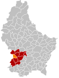 Map of Luxembourg with Steinfort highlighted in orange, and the canton in dark red | ||
| Coordinates: 49°39′36″N 5°54′56″E / 49.66°N 5.9156°ECoordinates: 49°39′36″N 5°54′56″E / 49.66°N 5.9156°E | ||
| Country |
| |
| Canton | Capellen | |
| Government | ||
| • Mayor | Jean-Marie Wirth | |
| Area | ||
| • Total | 12.16 km2 (4.70 sq mi) | |
| Area rank | 93rd of 105 | |
| Highest elevation | 349 m (1,145 ft) | |
| • Rank | 89th of 105 | |
| Lowest elevation | 288 m (945 ft) | |
| • Rank | 92nd of 105 | |
| Population (2014) | ||
| • Total | 4,700 | |
| • Rank | 29th of 105 | |
| • Density | 390/km2 (1,000/sq mi) | |
| • Density rank | 19th of 105 | |
| Time zone | CET (UTC+1) | |
| • Summer (DST) | CEST (UTC+2) | |
| LAU 2 | LU00009011 | |
| Website | steinfort.lu | |

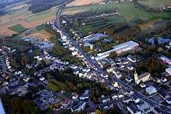
Steinfort (Luxembourgish: Stengefort) is a commune and town in western Luxembourg. It is part of the canton of Capellen, which is part of the district of Luxembourg.
As of 2005, the town of Steinfort, which lies in the north of the commune, has a population of 2,184. Other towns within the commune include Hagen, Kleinbettingen and Grass.
Transport
Road
Steinfort lies at the Belgian/Luxembourg border on the Route d'Arlon, the original road linking Luxembourg City to Arlon.
Rail
Steinfort[1] was served by a railway that stretched from Pétange to Ettelbruck in the north of the country. Despite the line's closure in 1967, the rails were never lifted and old rail infrastructure is still visible through Steinfort, where it crosses Route D'Arlon at a level crossing.
Nearest railway stations:
Notable Inhabitants
- Jean Asselborn (* 27. April 1949), Luxemburgish politician
References
External links
-
 Media related to Steinfort at Wikimedia Commons
 |
Hobscheid | | ||
| Arlon (BE-WLX) | |
Koerich | ||
| ||||
| | ||||
| Garnich | Mamer |
| |
Arlon (BE-WLX) | | ||
| Arlon (BE-WLX) | |
Garnich | ||
| ||||
| | ||||
| Käerjeng |
 | ||