Steimbke
| Steimbke | ||
|---|---|---|
| ||
 Steimbke | ||
Location of Steimbke within Nienburg/Weser district 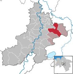
 | ||
| Coordinates: 52°39′44″N 9°24′15″E / 52.66222°N 9.40417°ECoordinates: 52°39′44″N 9°24′15″E / 52.66222°N 9.40417°E | ||
| Country | Germany | |
| State | Lower Saxony | |
| District | Nienburg/Weser | |
| Municipal assoc. | Steimbke | |
| Government | ||
| • Mayor | Friedrich Andermann (CDU) | |
| Area | ||
| • Total | 63.06 km2 (24.35 sq mi) | |
| Population (2015-12-31)[1] | ||
| • Total | 2,466 | |
| • Density | 39/km2 (100/sq mi) | |
| Time zone | CET/CEST (UTC+1/+2) | |
| Postal codes | 31634 | |
| Dialling codes | 05026 | |
| Vehicle registration | NI | |
| Website | www.steimbke.de | |

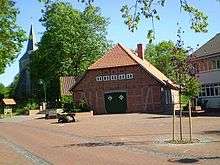
town hall square and church
Steimbke is a municipality in the district Nienburg, in Lower Saxony, Germany. It is situated approximately 12 km east of Nienburg, and 40 km northwest of Hanover, in a swamp and heathland, whereas the Blindesee takes centre stage.
Policy
Municipality of Steimbke
The villages Steimbke, Wendenborstel, Glashof, Eckelshof, Lichtenhorst, Lichtenmoor, and Sonnenborstel comprise the municipality of Steimbke. Steimbke is also the seat of the ("collective municipality") Steimbke.
Municipal council
The municipal council Steimbke has 12 members elected and a mayor elected directly. Since the local election on September 10, 2006, two parties and one Wählergemeinschaft represent it.
History
- First Steimbke document is from 1175.
- During the Thirty Years' War Steimbke was taken by catholic Tilly temporarily.
In development of the village, the industrial union "Gewerkschaft Brigitta" had the greatest share in 1934 by beginning oil production. "Brigitta" established an estate for industrial workers with bounteous sports facilities, a stadion with flood light and an indoor- as well as an outdoor swimming pool. In the meantime, the reduction of oil production has resulted to the abolishment of the pumpjacks that in former times have been Steimbke's landmark. By the date of June 30, 2005, Steimbke had a population of 2.739.
References
External links
- Official Web site (German)
- Sports club Steimbke (German)
- Steimbke auxiliary firefighters (German)