Steep Hill Brook (New Jersey)
| Steep Hill Brook | |
|---|---|
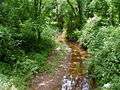 Steep Hill Brook viewed from Blackwells Mills Road | |
| Country | United States |
| Basin | |
| Main source | 40°29′43″N 74°32′41″W / 40.49528°N 74.54472°W |
| River mouth |
56 ft (17 m) 40°28′24″N 74°33′32″W / 40.47333°N 74.55889°WCoordinates: 40°28′24″N 74°33′32″W / 40.47333°N 74.55889°W |
| Progression | Six Mile Run, Millstone River, Raritan River, Atlantic Ocean |
| River system | Raritan River system |
Steep Hill Brook is a tributary of Six Mile Run in central and north central Franklin Park, Somerset County, New Jersey in the United States.
Course
Steep Hill Brook's source is at 40°29′43″N 74°32′41″W / 40.49528°N 74.54472°W,[1] in a pond near the intersection of Amwell Road and Van Cleef Road. It starts in Scott Farm, a local farm bordering Van Cleef Road and Amwell Road. It flows south into the Six Mile Run Reservoir Site, a preserved area around Six Mile Run. It crosses Blackwells Mills Road and drains into Six Mile Run at 40°28′24″N 74°33′32″W / 40.47333°N 74.55889°W.[1]
Accessibility
Steep Hill Brook is a rather short stream. It only crosses one road, Blackwells Mills Road, where it is easily accessible on one side. It can be accessed by some trails in the woods too.
Animal life
Steep Hill Brook has many fish, as they prefer the oxygenated environment. There are several frogs in the slow moving places, although the fine gravel is less hospitable to them than mud.
Terrain
The streambed of Steep Hill Brook is composed of fine reddish gravel in most places. Some shale cliffs may be found along its banks. This stream is generally medium-fast flowing and shallow. "Sandbars" formed by accumulation of gravel are common. Short stalactites may be found growing at the bridge at Blackwells Mills Road.
Sister tributaries
Gallery
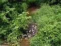 Steep Hill Brook Crossing Blackwells Mills Road
- Steep Hill Brook Crossing Blackwells Mills Road
 Stalactites at Steep Hill Brook
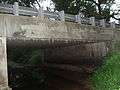 Zoomed out version of stalactites to get a perspective on the size
See also
References
- 1 2 "GNIS Detail - Steep Hill Brook". USGS. Retrieved 1 August 2010.