Stede Broec
| Stede Broec | |||
|---|---|---|---|
| Municipality | |||
|
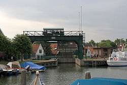
Broekerhaven waterway | |||
| |||
.svg.png) Location in North Holland | |||
| Coordinates: 52°42′N 5°14′E / 52.700°N 5.233°ECoordinates: 52°42′N 5°14′E / 52.700°N 5.233°E | |||
| Country | Netherlands | ||
| Province | North Holland | ||
| Established | 1 January 1979 | ||
| Government[1] | |||
| • Body | Municipal council | ||
| • Mayor | Marian Goldschmeding (PvdA) | ||
| Area[2] | |||
| • Total | 16.37 km2 (6.32 sq mi) | ||
| • Land | 14.63 km2 (5.65 sq mi) | ||
| • Water | 1.74 km2 (0.67 sq mi) | ||
| Elevation[3] | −1 m (−3 ft) | ||
| Population (May 2014)[4] | |||
| • Total | 21,478 | ||
| • Density | 1,468/km2 (3,800/sq mi) | ||
| Time zone | CET (UTC+1) | ||
| • Summer (DST) | CEST (UTC+2) | ||
| Postcode | 1610–1614 | ||
| Area code | 0228 | ||
| Website |
www | ||

Stede Broec (![]() pronunciation )(West Frisian: Stee Broek) is a municipality in the Netherlands, in the province of North Holland and the region of West-Frisia. The name Stede Broec derives from "stede" (meaning city) and "broec" (meaning swamp).
pronunciation )(West Frisian: Stee Broek) is a municipality in the Netherlands, in the province of North Holland and the region of West-Frisia. The name Stede Broec derives from "stede" (meaning city) and "broec" (meaning swamp).
Population centres
The municipality of Stede Broec consists of the following cities, towns, villages and/or districts: Bovenkarspel, Grootebroek, [ and Lutjebroek.
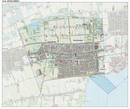
Dutch topographic map of the municipality of Stede Broec, June 2015
History
Grootebroek and Bovenkarspel together received city rights in 1364, under the name of Broek. In 1402 Lutjebroek shared in the city rights and Hoogkarspel joined in 1403. Andijk was the fifth to join in 1786. In 1825 the city was dissociated.
Stede Broec is located in the region of West Friesland consisting of all the land surrounded by the Westfriese Omringdijk, a dike which then protected the land against the dangers of the tides of the Zuider Zee.
Local government
The municipal council of Stede Broec consists of 19 seats, which are divided as follows (as of March 3rd 2010):
- CDA - 5 seats
- Open en Duidelijk Stede Broec - 4 seats
- PvdA/GroenLinks - 3 seats
- Gemeentebelangen - 2 seats
- Onafhankelijke Partij - 2 seats
- VVD - 2 seats
References
- ↑ "Portefeuilleverdeling College" [Tasks division of the board] (in Dutch). Gemeente Stede Broec. Retrieved 7 March 2014.
- ↑ "Kerncijfers wijken en buurten" [Key figures for neighbourhoods]. CBS Statline (in Dutch). CBS. 2 July 2013. Retrieved 12 March 2014.
- ↑ "Postcodetool for 1611KW". Actueel Hoogtebestand Nederland (in Dutch). Het Waterschapshuis. Retrieved 7 March 2014.
- ↑ "Bevolkingsontwikkeling; regio per maand" [Population growth; regions per month]. CBS Statline (in Dutch). CBS. 26 June 2014. Retrieved 24 July 2014.
External links
 Media related to Stede Broec at Wikimedia Commons
- Official website
 |
Medemblik | | ||
| Drechterland | |
Enkhuizen | ||
| ||||
| | ||||
| Drechterland | Markermeer |
