Stannington, Sheffield
| Stannington | |
 Stannington Cross |
|
 Stannington |
|
| Population | 10,747 [1] |
|---|---|
| Metropolitan borough | Sheffield |
| Metropolitan county | South Yorkshire |
| Region | Yorkshire and the Humber |
| Country | England |
| Sovereign state | United Kingdom |
| Post town | SHEFFIELD |
| Postcode district | S6 |
| Dialling code | 0114 |
| Police | South Yorkshire |
| Fire | South Yorkshire |
| Ambulance | Yorkshire |
| EU Parliament | Yorkshire and the Humber |
| UK Parliament | Sheffield Hallam |
Coordinates: 53°23′46″N 1°32′10″W / 53.396°N 1.536°W
Stannington is a suburb in the City of Sheffield. The area is located in the civil parish of Bradfield, and is in the electoral ward of Stannington. Stannington is situated right on the western edge of the Sheffield urban area
History and description
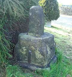
Stannington is a suburb of Sheffield to the west of the city centre, located on the hill between the River Rivelin and River Loxley. There is evidence of Roman occupation of the area which comes from tablets found on the Stannington side of the Rivelin Valley which record the granting of land to retiring Roman auxiliaries of the Sunuci tribe. Other evidence of nearby Roman occupation comes from finds on Walkley Bank Road, which leads onto the ridge facing Stannington.[2][3][4] The village has grown from the two settlements of Upper Gate and Nethergate. The settlement was mentioned in medieval times when a charter was granted to all men of Stannington and Morewood giving them the right to gather green and dry wood and turn out their cattle throughout the whole forest in Rivelin for a payment of four pounds in silver yearly. Stannington cross dates from the same period, Harrison's survey of 1637 describes it as a "stump cross of medieval origin". The date of erection has been estimated as 13th or 14th century, it stands at the junction of Oldfield Road and Stannington Road.[5] Stannington officially became part of Sheffield in 1974 under the Local Government Act 1972. Previous to that it had been part of Wortley Rural District and was on the boundary of the West Riding of Yorkshire. The village of Stannington, which is part of the original Wortley district and marked by the "Rural District of Wortley" sign at the junction of Oldfield Road and Stannington Road; and the newer conurbations of Deer Park and Roscoe Bank primarily grew out from Malin Bridge from the 1960s onwards.
Significant buildings in the area include the Christ Church parish church on Church Street; the Unitarian chapel, Underbank Chapel; and the country house, Revell Grange; all of which are Grade II listed structures. Stannington is served by Sheffield Supertram Bus route SL2 which links it with Malin Bridge.
Industry
During the 1800s the Stannington area together with the nearby Loxley Valley became an important producer of refractory bricks for the expanding Sheffield steel industry. The bricks were used to line the furnaces and were made from ganister, a sort of sandstone and from fireclay from the Stannington pot clay seam which was prevalent in the area. Many ganister and fireclay mines and quarries existed in the area with the major ones being owned by the local firms of Siddons Brothers. (High Matlock Road ganister quarry) and J & J Dyson (firebrick works, Griff's Works, Stopes Road) which sprang up in the district. Refractory production ceased in 2012. Dyson's along with Wragg's and Marshall's (both in the Loxley Valley) specialised in manufacturing fireclay-based casting pit refractory hollowware for the steel industry worldwide. All three refractory plants (Dyson's, Marshall's and Wragg's) closed following a collapse in demand for casting pit refractories of the type made locally mainly because of the introduction of continuous casting of steel worldwide and the general demise of the British steel industry.
References
- ↑ Stannington is made up of 37 output areas in the Stannington ward and in 2011 had a population of 10,747. http://www.ukcensusdata.com/stannington-e05001062#sthash.4VwBR7MQ.YnpxUgX7.dpbs
- ↑ Hunter, Joseph (1819). Hallamshire. The History and Topography of the Parish of Sheffield in the County of York. London: Lackington, Hughes, Harding, Mayor & Jones. (wikisource)
- ↑ Waddington, Clive (2012). "Discovery and Excavation of a Roman Estate Centre at Whirlow, South-west Sheffield" (PDF). Council for British Archaeology. Retrieved 28 March 2014.
- ↑ Taylor, M. V.; Collingwood, R. G. (1929). "Roman Britain in 1929: I. Sites Explored: II. Inscriptions". Journal of Roman Studies. Society for the Promotion of Roman Studies. 19: 180–218. doi:10.2307/297347. JSTOR 297347.
- ↑ Stannington, Stannington Local History Group, p. 2
6. Battye, Ray, The Forgotten Mines Of Sheffield, ISBN 1-901587-40-1
External links
| Wikimedia Commons has media related to Stannington, South Yorkshire. |
- Stannington grid reference SK309889
| About Sheffield | |||||||
|---|---|---|---|---|---|---|---|
| Electoral wards |
| ||||||
| Suburbs and estates |
| ||||||
| Towns and villages |
| ||||||
| Other areas | |||||||
| |||||||